The seafloor mapping pioneered by Marie Tharp, an American geologist and cartographer, though originally underappreciated, ended up playing a key role in the acceptance of the theory of plate tectonics. This week the EGU is highlighting Tharp’s groundbreaking contributions by hosting both a press conference and a session in her honour at the Union’s virtual annual meeting, Sharing Geoscience Online.
“Marie Tharp is quite the hero for many!” says Susanne Buiter, one of the conveners of session TS14.1/GD6, which will be devoted to celebrating Tharp’s legacy by examining how her life’s work altered our understanding of the Earth’s oceans. In particular, Tharp’s seafloor maps, which were co-published with Bruce Heezen, revealed the submarine landscape in unprecedented detail. Her meticulous cartography showed that rather than being flat, as often had been presumed, the seafloor includes major features such as seamounts and volcanic chains, trenches, mid-ocean ridges, and transform faults.
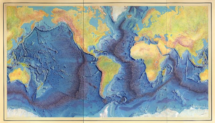
During the press conference held on Tuesday, Vicki Ferrini, a research scientist at Lamont-Doherty Earth Observatory at Columbia University, which was also Tharp’s home institution, provided an overview of the historical importance of this research. “Marie Tharp’s work revolutionised our understanding of the shape, texture and fabric of the global seafloor,” said Ferrini, as she highlighted the famous 1977 World Ocean Floor map. Tharp and Heezen produced this amazing map with the help of Heinrich Berann, an Austrian painter who was famous for creating panoramic maps using a combination of traditional map-making techniques and classical painting. “By doing this work together,” says Ferrini, “they were able to really make it much more understandable, both to scientists and the general public.”
Mathilde Cannat, a marine geoscientist at the Institut de Physique du Globe de Paris, who also spoke at the press conference, noted that Tharp co-authored the first articles describing the Central Atlantic Ocean’s major fracture zones, and highlighted how her research contributed directly to the recognition of the role of mid-ocean ridges in plate tectonics. “She had very scarce data, but she managed to produce … what she called physiographic diagrams that represented the topography in amazingly accurate ways,” said Cannat. “It is absolutely certain that without these incredible documents, plate tectonics wouldn’t have taken the shape it has taken,” she said.
The other press conference participants, Paul Wessel, a professor at SOEST at the University of Hawai’i at Manoa and the EGU ESSI Division Ian McHarg Medal winner for 2020, and Florian Schmid, a postdoctoral researcher at the Helmholtz Centre for Ocean Research, presented results from recent projects that underscore the importance of seafloor mapping studies that continue today. Wessel, who is known for his community work in developing free, open-source map-plotting software, showed journalists the latest results from his project, which is influenced by Tharp’s earlier work, of mapping the fabric of Cretaceous-age seafloor in the equatorial Ellice Basin.
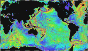
Ocean gravity map (Produced by NOAA)
“Seafloor bathymetry and tectonic fabric is fundamental information that informs models for plate tectonic evolution,” said Wessel during a pre-recorded presentation. “However, the Earth is very unevenly mapped by surface ships, leaving large areas with limited high-resolution data.”
Schmid then told members of the media about his ongoing research project in the Lau Basin in the southwestern Pacific Ocean, which he considers to be another example of research that is part of Tharp’s legacy. “The interesting thing about the Lau Basin,” said Schmid, “is that nowhere else on Earth there is processes of crustal destruction and creation in such proximity as fast as is happening here.”
Schmid, who called the region “a geologist’s paradise,” is using various geophysical techniques to better understand what processes formed the crust in the northern Lau Basin, where two spreading centers are found in close proximity to each other in a situation that Schmid describes as “pretty unique.”
The researchers emphasised how the results of these and other ongoing seafloor studies all build upon Tharp’s pioneering results and point to the importance of collaboration and cooperation between researchers and across disciplines when studying the seafloor. “Her work is one of the best early examples of what comes from sharing data and integrating data from multiple sources,” Ferrini said.
[Marie Tharp’s] work is one of the best early examples of what comes from sharing data and integrating data from multiple sources.
– Vicki Ferrini
Thursday’s session TS14.1/GD6, scheduled for Thursday 07 May from 14:00-15:45 CEST, will address plate tectonics based primarily on information from seafloor mapping using a variety of techniques and at regional to global scales, like Tharp’s groundbreaking work.