Fieldwork can take geoscientists to some of the most remote corners of the Earth in some of the harshest conditions imaginable, but stories from the field hardly make it into a published paper. In this blog post, Raffaele Bonadio, a PhD student in seismology at the Dublin Institute for Advanced Studies in Ireland, shares a particularly formidable experience in the field while aboard a research vessel in the North Atlantic Ocean.
We knew it would be stormy that night. At the previous evening’s briefing, the captain of the ship, composed and collected, notified us that we needed to make a diversion from the planned route to avoid getting too close to the eye of the storm, “We’ll slow down the vessel…” “kind of five metres swell expected”. He was calm and comfortable. The crew members were calm and comfortable. We, the guest scientists, were not.
Why were we in the middle of the ocean?
I was part of a team of researchers from the Dublin Institute for Advanced Studies working on the project SEA-SEIS (Structure, Evolution and Seismicity of the Irish offshore). Our task was to deploy a suite of seismometers on the bottom of the North Atlantic Ocean from our research vessel, the RV Celtic Explorer, to investigate the geological evolution of the Irish offshore.
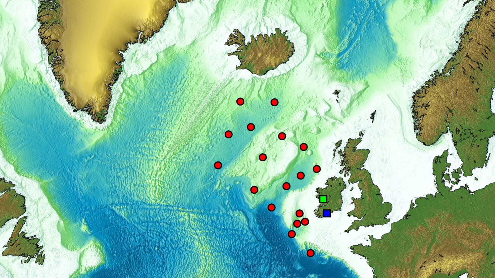
A map of the North Atlantic Ocean, showing the locations of seismometers deployed by the team’s research vessel, the RV Celtic Explorer. Credit: Raffaele Bonadio
Why study the Irish offshore?
The tectonic plate that Ireland sits on was deformed and stretched to form the deep basins offshore. The plate then broke, and its parts drifted away from each other, as the northern Atlantic Ocean opened. Hot currents in the convecting mantle of the Earth caused volcanic eruptions and rocks to melt 50-100 km below the Earth’s surface. These hot currents may have come from a spectacular hot plume rising all the way from the Earth’s core-mantle boundary (at 2891 km depth) to just beneath Iceland.
What do ocean bottom seismometers do?
Ocean bottom seismometers record the tiny vibrations of the Earth caused by seismic waves, generated by earthquakes and ocean waves. As the waves propagate through the Earth’s interior on their way to the seismic stations, they accumulate information on the structure of the Earth that they encounter. Seismologists know how to decode the wiggles on the seismograms to obtain this information. With this data, they can do a 3D scan (tomography) of what’s inside the Earth.

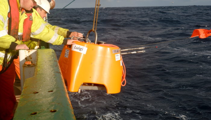
One of the research team’s seismometers being dropped into the North Atlantic Ocean. The instruments sink to the bottom of the ocean, where they measure the Earth’s movement. Credit: SEA-SEIS Team
In this project, we want to better understand how the structure of the tectonic plate varies from across the North Atlantic and what happens beneath the plates. And is there an enormous hot plume beneath Iceland, responsible for the country’s volcanoes today and the formation of Giant’s Causeway in Ireland? This is what we hope we will find out!
Experiencing an ocean storm
We were aboard the ship about 9 days and had just deployed “Ligea”, the 14th seismometer before the captain had notified us that a storm was heading our way.
While we were told in advance of the approaching storm, there was no way we could have imagined what it would be like to be in the middle of a stormy ocean. I had only heard some stories and I didn’t fully believe them…
I was awakened by the sound of my table lamp smashing on the ground, even the 15 cm protection edge around the table couldn’t help. The closet door opened and hit the wall. I managed not to fall off the bed, pointing my legs and make a crack with my back. I heard one of my colleagues laughing in the next cabin after a loud thud. “Did he just fall off the bed?” I thought to myself – his laugh did sound a bit of hysterical.
I realized a big wave had crashed on the side of the ship. I couldn’t believe that water and metal crashing together could make such a harsh bang. The previous evening was a continuation of bangs, splashes, sprinkles, bloops, clangs, and creaks … but even with all these noises and disturbances, I managed to sleep, exhausted from dizziness and sea-sickness.
I checked the clock on the wall: it was 3:20 in the morning. I looked at the porthole, due to the vertical movement my cabin was underwater half of the time. I walked through the cabin, trying to reach the toilet. “Oh, I wish they made the cabin smaller! I can’t reach both walls with my arms,” I said to myself. I opened the tap to refresh my face, the flowing water danced right and left across the basin. I then climbed up to the deck, I had to literally climb up the stairs. Up there I couldn’t see anything but darkness; I couldn’t see the boundary between the sky and the sea.
More than a week had passed since our departure, yet my body had still not adapted to this incessant movement. My eyes could not follow my body and my stomach did not react well, I couldn’t see anymore what was horizontal and what wasn’t. However, I wasn’t even scared, I believed nobody on the ship was (or is it only that I wanted to believe this?). It wasn’t fear, but rather an unceasing uncomfortable feeling: I knew I was more than 900 km from any dry land, in the middle of the North Atlantic Ocean, on a 66 m long vessel; I knew the captain and the crew were working hard to take us far from the storm. I was not scared…
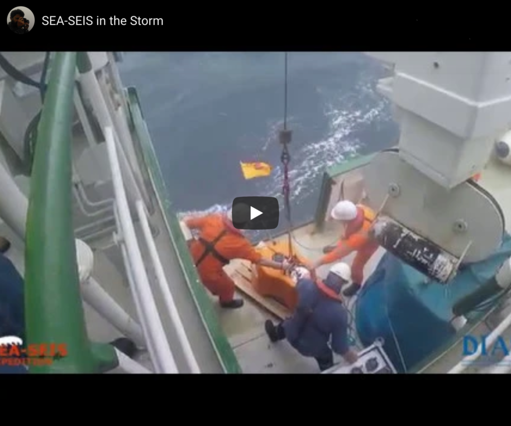
In a few hours we were planning to deploy an ocean bottom seismometer, a very sophisticated device that is able to operate at huge pressures at the bottom of the ocean; released from the ship it would sink and install itself on the seafloor 4 km under the surface of the waves. In other words, a 200 kg ‘little orange elephant’, as the students who supported us from land every day liked to call it! “Will we be able to deploy? Will we be able not to crash the instrument on the sides? Will we instead be able to keep our balance and walk up to the deck?”
“Yes, we will.”
How did this look like? Find out more in this video:
So, what did we accomplish?
As part of the SEA-SEIS project, led by Dr. Sergei Lebedev, our research team successfully deployed 18 seismometers at the bottom of the North Atlantic Ocean. The network covers the entire Irish offshore, with a few sensors also in the UK and Iceland’s waters. The ocean-bottom seismometers were deployed between 17 September and 5 October, 2018, and will be retrieved in April of 2020.
To find out more about the SEA-SEIS Projects, have a look at SEA-SEIS or check out our introductory video.
By Raffaele Bonadio, Dublin Institute for Advanced Studies, Ireland