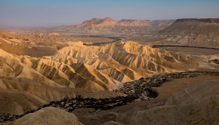
This is a photograph of Zin (or Tzin) Valley, taken from Midreshet Ben Gurion at Sede Boker, Negev Desert in Israel. The Zin Valley takes its name from the River Zin, which is now a dry river except for a few days of the year when heavy rainfall can form dangerous flash floods. The River Zin originates from the Makhtesh Ramon (Crater Ramon), the biggest erosion crater in the world. It is located at the peak of Mount Negev, approximately 85 km south of the city of Beersheva, and reaches its final destination when it enters the Dead Sea.
The valley plateau was originally located at the bottom of the Thetis ocean and is formed by hard chalk layers. When the ocean retreated, it left behind a hump-shaped hill which was soon flattened by erosion. The entire area of the Negev, including the Zin valley and the nearby Ein Avdat canyon, is formed by alternated terraces and slopes that are shaped through erosion.
It is believed that the shapes seen in this photograph formed through late Miocene and Pleistocene tectonic processes. These processes include tectonic uplift on the plateau and complex water and wind erosion processes which continue to shape the valleys, riverbeds and rocks. When the Rift Valley depression started to form and then widen, the rivers changed the direction of their flow from the Mediterranean to the Dead Sea.
Apart from their amazing and unique geological features, the Zin valley and the Negev also have a significant historical and cultural value. The river represents the border of the biblical Israel and it served as part of the Silk Road which linked the Mediterranean Sea to Petra. Furthermore, there is still a semi-nomadic culture in the region which has roots as far back as 5,000 BC.
This photograph not only shows beautiful geological and naturalistic features but also historical and cultural elements which make the Zin Valley and Negev Desert both unique and interesting.
By Mariasilvia Giamberini and Antonello Provenzale, Institute of Geoscience and Earth Resources, National Research Council of Italy
If you pre-register for the 2018 General Assembly (Vienna, 08–13 April), you can take part in our annual photo competition! From 15 January until 15 February, every participant pre-registered for the General Assembly can submit up three original photos and one moving image related to the Earth, planetary, and space sciences in competition for free registration to next year’s General Assembly! These can include fantastic field photos, a stunning shot of your favourite thin section, what you’ve captured out on holiday or under the electron microscope – if it’s geoscientific, it fits the bill. Find out more about how to take part at http://imaggeo.egu.eu/photo-contest/information/.
Imaggeo is the EGU’s online open access geosciences image repository. All geoscientists (and others) can submittheir photographs and videos to this repository and, since it is open access, these images can be used for free by scientists for their presentations or publications, by educators and the general public, and some images can even be used freely for commercial purposes. Photographers also retain full rights of use, as Imaggeo images are licensed and distributed by the EGU under a Creative Commons licence. Submit your photos at http://imaggeo.egu.eu/upload/.


