Despite being a natural hazard which requires careful management, there is no doubt that there is something awe inspiring about volcanic eruptions. To see an erupting volcano up close, even fly through the plume, is the thing of dreams. That’s exactly what Jamie Farquharson, a researcher at Université de Strasbourg (France) managed to do during the eruption of the Icelandic volcano Bárðarbunga. Read about his incredible experience in today’s Imaggeo on Monday’s post.
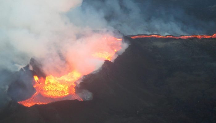
The picture shows the Holuhraun eruption and was taken by my wife, Hannah Derbyshire. It was taken from a light aircraft on the 11th of November of 2014, when the eruption was still in full swing, looking down into the roiling fissure. Lava was occasionally hurled tens of metres into the air in spectacular curtains of molten rock, with more exiting the fissure in steady rivers to cover the surrounding landscape.
Iceland is part of the mid-Atlantic ridge: the convergent boundary of the Eurasian and North American continental plates and one of the only places where a mid-ocean ridge rears above the surface of the sea. It’s situation means that it is geologically dynamic, boasting hundreds of volcanoes of which around thirty volcanic systems are currently active. Holuhraun is located in east-central Iceland to the north of the Vatnajökull ice cap, sitting in the saddle between the Bárðarbunga and Askja fissure systems which run NE-SW across the Icelandic highlands.
Monitored seismic activity in the vicinity of Bárðarbunga volcano had been increasing more-or-less steadily between 2007 and 2014. In mid-August 2014, swarms of earthquakes were detected migrating northwards from Bárðarbunga, interpreted as a dyke intruding to the east and north of the source. Under the ice, eruptions were detected from the 23rd of August, finally culminating in a sustained fissure eruption which continued from late-August 2014 to late-February of the next year.
My wife and I were lucky enough to have booked a trip to Iceland a month or so before the eruption commenced and, unlike its (in)famous Icelandic compatriot Eyjafjallajökull, prevailing wind conditions and the surprising lack of significant amounts of ash from Holuhraun meant that air traffic was largely unaffected.
At the time the photo was taken, the flowfield consisted of around 1000 million cubic metres of lava, covering over 75 square kilometres. After the eruption died down in February 2015, the flowfield was estimated to cover an expanse of 85 square kilometres, with the overall volume of lava exceeding 1400 million cubic metres, making it the largest effusive eruption in Iceland for over two hundred years (the 1783 eruption of Laki spewed out an estimated 14 thousand million cubic metres of lava).
Numerous “breakouts” could be observed on the margins of the flowfield as the emplacing lava flowfield increased in both size and complexity. Breakouts form when relatively hot lava, insulated by the cooled outer carapace of the flow, inflates this chilled carapace until it fractures and allows the relatively less-viscous (runnier) interior lava to spill through and form a lava delta. Gas-rich, low-viscosity magma often results in the emission of high-porosity (bubbly) lava. My current area of research examines how gases and liquids can travel through volcanic rock, a factor that is greatly influenced by the evolution of porosity during and after lava emplacement.
Flying through the turbulent plume one is aware of a strong smell of fireworks or a just-struck match: a testament to the emission of huge volumes of sulphur dioxide from the fissure. Indeed, the Icelandic Met Office have since estimated that 11 million tons of SO2 were emitted over the course of the six-month eruption, along with almost 7 million tons of CO2 and vast quantities of other gases such as HCl. These gases hydrate and oxidise in the atmosphere to form acids, in turn leading to acid rain. The environmental impact of Holuhraun as a gas-rich point source is an area of active research.
By Jamie Farquharson, PhD researcher at Université de Strasbourg (France)
Imaggeo is the EGU’s online open access geosciences image repository. All geoscientists (and others) can submit their photographs and videos to this repository and, since it is open access, these images can be used for free by scientists for their presentations or publications, by educators and the general public, and some images can even be used freely for commercial purposes. Photographers also retain full rights of use, as Imaggeo images are licensed and distributed by the EGU under a Creative Commons licence. Submit your photos at http://imaggeo.egu.eu/upload/.