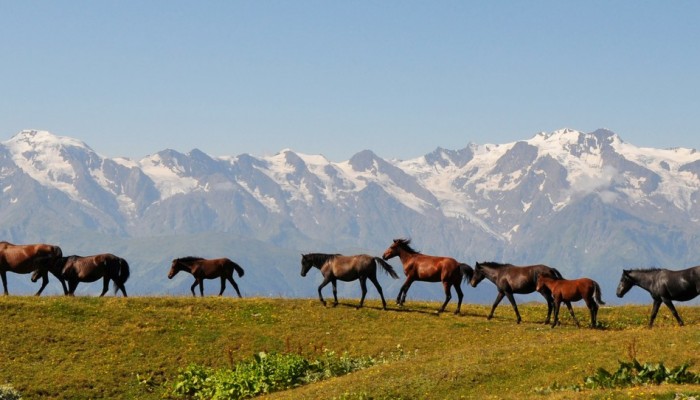
Today’s Imaggeo on Mondays picture shows the central section of the Svaneti Range, located in the Svaneti Region – a historic province of northwestern Georgia. The range is the second biggest range formed by the modern glaciation on the southern slopes of the Georgian Caucasus Mountains. In today’s post, Levan Tielidze, a researcher at Ivane Javakhishvili Tbilisi State University, writes about the ice capped peaks of these high mountains and highlights the precarious balance of this cryospheric system.
Svaneti range is approximately 100 km long and is distinguished by the height of its relief, as well as by the fact that the area covered by glaciers in the region exceeds that covered elsewhere in the southern slopes of the Georgian Caucasus.These features define the range and lead it to be divided into three sections: eastern, central (shown in this picture) and western. The eastern and western sections are lower in altitude than the central region and modern ice cover cannot be found there, with the exception of Mount Dadiashi which stands at 3535 m asl.
However, glaciers do cap the peaks in the central areas of the range, and can be found between the sections of Lasili and Leshnuri. Here is where you’ll find the highest peak of the mountain range: Laila (Laila-Lehli) -4009 m asl.
The glaciers in this region are retreating and losing volume. Data from the 1960s indicated that glaciers in the range numbered up to 48 and covered an area of approximately 27.76 km2 , equivalent to the size of just over 2500 football pitches. By 2014 the area covered by the glaciers in the region had shrunk by 27.5% and now only covers approximately 20.13 km2.
Some of the largest glaciers of the northern slopes of the range are formed on Laila peak, which itself is covered by a glacier cap. Among these glaciers the largest is Eastern Laila, located in the Khumpreri River basin. The glacier is formed of two ice streams which flow from separate valleys. In 1960 the glacier area was close to 5.96 km2; its terminus ended at a height of 2300 meters asl. By 2014 the eastern Laila’s area decreased to 3.55 km2 and has retreated to an altitude of 2640 m asl. The total glacier length is now approximately 4.52 kilometers.
The glaciers are an important source of water for agricultural production in Georgia, and runoff in large glacially-fed rivers (Kodori, Enguri, Rioni, Tskhenistskali, Nenskra) supplies several hydroelectric power stations. In addition, glacier outburst floods and related debris flows are a significant hazard in Georgia and in the Caucasus. Future trends in glacier change are thus a topic of considerable interest to the region.
By Levan Tielidze, Institute of Geography, Tbilisi State University, Georgia
If you pre-register for the 2016 General Assembly (Vienna, 17 – 22 April), you can take part in our annual photo competition! From 1 February up until 1 March, every participant pre-registered for the General Assembly can submit up three original photos and one moving image related to the Earth, planetary, and space sciences in competition for free registration to next year’s General Assembly! These can include fantastic field photos, a stunning shot of your favourite thin section, what you’ve captured out on holiday or under the electron microscope – if it’s geoscientific, it fits the bill. Find out more about how to take part at http://imaggeo.egu.eu/photo-contest/information/.


