Today in GeoTalk, we’re talking to Veerle Vanacker, and eminent geomorphologist and winner of the EGU Division Outstanding Young Scientist Award last year. She tells us about her breakthroughs in modelling land use change and erosional processes…
First, could you introduce yourself and tell us a little about what you are currently working on?
I currently work as a lecturer in geomorphology at the University of Louvain (UCL, Belgium). My research focuses on the interactions between human activities and earth surface processes. After graduating from university (KULeuven, Belgium) in 1998, I started to conduct fieldwork in the Ecuadorian Andes in the scope of an inter-university cooperation project. My PhD research aimed to improve our understanding of the impact of land use change on geomorphic processes in tropical mountain environments. Remote sensing was then increasingly used to extract physical land properties. In 2002, I started as a post-doc with Eric Lambin, who chaired the IGBP Land Use Land Cover Change project at the time. Later, I relocated to the University of Hannover (Germany) to learn about new geochemical tracers to track erosion and sedimentation rates.

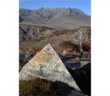
Veerle Vanaker out in the field (literally!). (Credit: Veerle Vanaker)
Last year, you received a Division Outstanding Young Scientists Awardfor your work on how land use change can influence erosion rates in mountainous regions. Could you tell us a bit more about your research in this area?
In mountainous regions, we commonly observe high erosion rates and elevated sediment fluxes. They are not directly a sign of increased human disturbances, as natural erosion rates in mountainous sites can be high due to steep slopes, tectonic activity, and the erosive climate. How to separate these processes from the impact of land use on sediment flux was a question that urgently needed answering. By combining spatial information (from remote sensing) with sediment flux data and geochemical tracers, we were able to quantify the changes in erosion rates due to anthropogenic disturbance.
The relationship between land use and erosion has been a subject of much debate, something your methods have helped resolve. Could you describe their key points?
Previous studies mostly used a time series of river sediment fluxes to analyse how erosion and sediment yield varied over time and space, but modern sediment fluxes don’t provide a good baseline for assessing human impacts on sediment flux as they are biased by both short records and long-term human occupation. Instead, we need natural benchmarks that we can compare disturbed areas to. In our studies, we established natural rates of sediment flux by looking at the concentration of terrestrial cosmogenic nuclides in river sediments. The beryllium isotope, 10Be, allows long-term catchment-wide denudational flux to be quantified. Modern sediment fluxes can then be compared to these rates to assess the impact of anthropogenic disturbance.

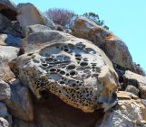
Vegetation on a degrated slope. Vegetation is a major control of runoff, erosion and sediment mobilization in highly degraded catchments. (Credit: Veerle Vanaker)
What activities have the greatest influence on sediment production and how can we reduce their impact?
Our studies showed that the conversion from native forests to agricultural land causes soil erosion to accelerate by up to two orders of magnitude. The main driver for this is the decrease in the protective ground vegetation cover. Such a loss of land cover can trigger shallow landslides, which present a major threat to human life, property and infrastructure.
Through our work in experimental catchments in the Andes, we were able to show that revegetation programs coupled with bioengineering significantly reduces sediment production and mobilisation. Revegetating active gully channels is a particularly efficient way of enhancing sediment trapping and infiltration of runoff water in gully channels, rather than transporting it downslope.
Lastly, what are your research plans for the future?
Human pressure on the land is globally increasing, which poses a serious threat to environmental sustainability. I’m highly interested in the interactions between soil systems and water, and what will happen to sediment and nutrient fluxes under changing human pressure. We observe that soil processes play a major role in the resilience of an ecosystem to human disturbance. To understand these interactions, we need new data on the rates of soil formation, chemical weathering and erosion fluxes for both undisturbed and anthropogenically disturbed sites. By combining data from different geochemical techniques, such as terrestrial and meteoric cosmogenic nuclides, with remote sensing data from very high resolution images, we should be able to make major advances in these research topics.
If you’d like to suggest a scientist for an interview, please contact Sara Mynott.
Pingback: Geotalk: Veerle Vanacker on land use, degredati...