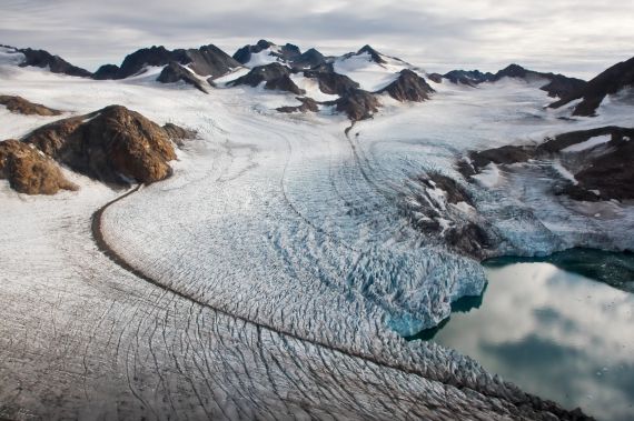
The picture below shows several small glaciers surrounding the Greenland ice sheet, in Tassilaq, near Kulusuk, East Greenland. The dark lines are glacial moraines, responsible for the transport of rock material from mountains towards sea.
The photographer, Romain Schläppy, highlights that “an important scientific topic consists to place the recent and ongoing Greenland warming in the broader context of past changes in south Greenland land climate, vegetation, sedimentation and ice history”. Indeed, with the recent report produced by the Ice2Sea programme, there is a lot of work being done to investigate glacial mass balance, with one particularly cool model looking at the how the edges of the Greenland ice sheet are changing in the greatest detail.

“The power of ice” by Romain Schläppy, distributed by the EGU under a Creative Commons licence.
Most models separate large regions into squares, for surface modelling, or cubes, for something a little more 3D. This makes all the data that goes into a model easier to handle as you simplify the variation in, say, runoff rate, over a large area into a single value for runoff. While this makes information easier to handle, you also lose a lot of resolution, not something you want when big changes are happening on small scales.
This is the case in the Greenland ice sheet. The edges are advancing and retreating year in and year out, as they are influenced by the climate and conditions of the ocean around them, but the centre of the ice sheet remains relatively stable. This means that parameters such as meltwater runoff will be changing lots at the glacier front and relatively little in the middle.
To combat this, climate modellers have produced a new model using triangular blocks rather than square ones, so instead of having many equally large simplifications, you can have large, simple triangles where there’s not much going on and tiny ones to capture all the detail where the excitement is happening!
Reference:
Vaughan, D.G., Aðalgeirsdóttir, G., Agosta, C. et al. From Ice to High Seas, The ice2sea Consortium: 2013.
Imaggeo is the EGU’s online open access geosciences image repository. All geoscientists (and others) can submit their images to this repository and since it is open access, these photos can be used by scientists for their presentations or publications as well as by the press and public for educational purposes and otherwise. If you submit your images to Imaggeo, you retain full rights of use, since they are licensed and distributed by the EGU under a Creative Commons licence.


