We introduce you to our new blog series Bits & Bites of Geodesy. In this blog post series, we aim to communicate small chunks of geodetic fun facts that are easy to digest. In short, posts meant for everyone, facts about geodetic measurement techniques, challenges, and concepts are presented. These bite-sized articles will unravel the often-overlooked details and intricate aspects of geodetic science. Let’s embark on a journey exploring the world of geodesy. Let’s answer questions you were always curious about and trigger questions you haven’t thought of yet. Please send us questions or suggestions if you want a topic to be featured in this series so we can unravel the world of geodesy together. These short reads aim to demystify the terminology, offering insights into how geodetic concepts shape our understanding of the world and facilitate diverse applications. Stay tuned for the upcoming instalments in our “Bits and Bites of Geodesy” series as we navigate the intriguing world of geodesy, starting with the centre of our planet.
Where is the centre of the Earth? Why do we care?
Embarking on a journey to the centre of our planet unveils crucial concepts to understanding the Earth’s physical characteristics. But before we start our little adventure to Earth’s centre, we must understand which centre we are interested in. Yes, Earth has more than one centre, depending on what we look at. On the one hand, there is the centre of the figure (CF), which is the geometric centre of the shape of the Earth, also known as the centroid. On the other hand, as Earth is a dynamic physical body, it has a centre of mass (CM), also called the geocenter (Fig. 1).
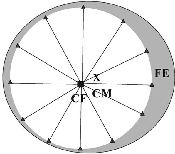
Fig.1: Modified from Tregoning, P., and van Dam, T. (2005) (Fig.1c): in the theoretical situation of having geodetic sites evenly spaced over the entire surface of the Earth (including in the oceans), the center of figure (CF, solid square) approximates the center of the solid Earth. The cross represents the position of the geocenter (CM) of the whole Earth system. FE illustrates the fluid envelope of ocean and atmosphere mass distribution.
The definition of the centre of the Earth plays a vital role in defining the origins of reference systems. For the International Terrestrial Reference System (ITRS) (realised in the ITRF), the origin of the coordinate system is defined as the geocenter of the whole Earth system, including oceans and atmosphere. The geocenter is defined as the long-term average centre of mass, which can be measured, for example, with satellite laser ranging (SLR). The distance between an SLR measurement station on the Earth and a satellite equipped with retroreflectors is derived from the two-way runtime of a laser pulse. While the ground stations are fixed to the solid Earth, the satellites’ trajectories respond to the centre of mass. However, the planetary body is not static but consists of dynamic systems. These cause the centre of mass to change over time on the scale of millimetres, an effect called “geocenter motion”.
Since applications of geodetic measurements have their origin in the geocenter and require millimetre accuracy today, the geocenter motion must be accounted for. A prominent example is the process of thermal expansion of the ocean, which contributes to the rise in total sea level and is an important measure to quantify climate change. Thermal expansion of the ocean can be estimated by measuring mean sea level rise and subtracting the mass component of the sea level rise.
The geometrical component of sea level rise can be observed with satellite radar altimeters, while the mass change component can be observed with satellite gravimetry missions like the current GRACE-FO. Both types of satellite observations are sensitive to geocenter motion but are not able to measure it independently. Geocenter motion can be observed with geodetic techniques such as GNSS and SLR but comes with high uncertainties. For satellite gravimetry and altimetry observations, the instantaneous geocenter motion must be corrected as it is one of the most significant uncertainty contributors to the global water budget observed by GRACE. An improved observation of geocenter motion is especially needed because different corrections divert up to 0.42 mm/yr. For comparison, thermal expansion accounts for about 1 mm/yr sea level rise, which makes geocenter motion corrections a large uncertainty source for these satellite measurements.
Overall, this shows that we care about where the centre of Earth is precisely. In order to study global geophysical processes on a millimetre level, we first need knowledge about the position of the geocenter over time with high accuracy.
References:
Blazquez, A., Meyssignac, B., Lemoine, J. M., Berthier, E., Ribes, A., & Cazenave, A. (2018). Exploring the uncertainty in GRACE estimates of the mass redistributions at the Earth surface: implications for the global water and sea level budgets. Geophysical Journal International, 215(1), 415-430.
Tregoning, P., and van Dam, T. (2005), Effects of atmospheric pressure loading and seven-parameter transformations on estimates of geocenter motion and station heights from space geodetic observations, J. Geophys. Res., 110, B03408, doi:10.1029/2004JB003334
Petit, G., Luzum, B. (Eds.), 2010. IERS Conventions (2010), IERS Technical Note 36. Verlag des Bundesamts für Kartographie und Geodäsie, Frankfurt am Main, 179 pp.
Wu, X., Ray, J., & van Dam, T. (2012). Geocenter motion and its geodetic and geophysical implications. Journal of Geodynamics, 58, 44-61.