Stories from the field – how exactly are those GPS data collected?
The geodesy community at large benefits from the many science projects with open data policies. A user simply has to navigate to a data portal, download the data, and within a matter of moments a world of possibilities opens up for potential research. But where exactly do these data come from? While scientific results get published, the complicated aspects of field work and the immense challenges associated with collecting geodetic data often get overlooked.
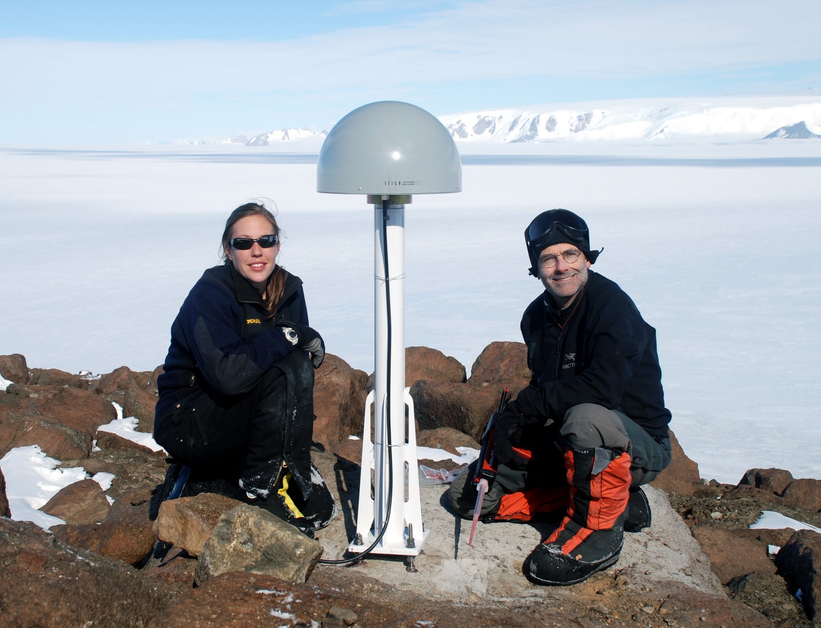
Stephanie Konfal (left) and Eric Kendrick (right) installing a GPS antenna and monument in bedrock on Deverall Island, the southern-most island in the world. Photo credit: www.polenet.org
My name is Stephanie Konfal and I am part of the Antarctic network (ANET) component of the Polar Earth Observing Network (POLENET) project, funded by the U.S. National Science Foundation. The goal of the project is to utilize GPS and seismic data to improve our understanding of how the solid earth and ice sheets interact. By measuring earth deformation and mapping the interior structure of the Earth, we aim to better understand Glacial Isostatic Adjustment (GIA), ice mass change, and sea level contribution from the Antarctic Ice Sheet. My research focuses on the GPS side of the project, and I have spent many months deploying and maintaining GPS stations in Antarctica.
While science field work in Antarctica primarily takes place during the austral summer from roughly November to February, logistical planning starts many months in advance, typically as soon as the previous field season ends. Even after the immense task of designing and planning the initial network has been accomplished, yearly requirements such as monitoring the state of health of existing instruments, designing and implementing station improvements, ordering and shipping equipment, specifying field gear requirements, analyzing satellite imagery to determine landing conditions, forming a field team and organizing training, assisting with the medical/physical qualification and travel process, and perhaps most significantly, negotiating field site visits by balancing a myriad of variables from station status to equipment/passenger weight loads to aircraft capabilities and fuel limitations – these tasks all require a small army of individuals dedicating countless hours of time to make the pieces fit together into a functional field season, with the division of labor extending beyond the immediate ANET-POLENET research team to include partnerships with UNAVCO (geodetic facility) and IRIS/PASSCAL (seismic facility), as well as ASC (Antarctic Support Contract) personnel.
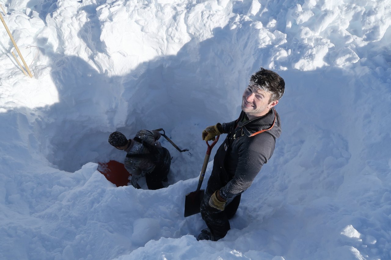
While POLENET-ANET GPS sites are installed on bedrock that typically remains snow-free, seismic systems are often installed in locations where snow drift accumulation can be significant. In these scenarios it’s “all hands on deck”, with all field team members helping to resurrect equipment burried many feet below the surface. In this photo, Peter Matheny (left, GPS field team) and Austin White-Gaynor (right, seismic field team) dig up a buried POLENET-ANET seismic station in West Antarctica. Photo credit: www.polenet.org
When the field season finally begins, so does a whole new set of tasks. From big physical jobs like pulling sleds full of heavy equipment up mountains, to small hurdles like successfully urinating into a bottle in -40C and strong winds, field work in Antarctica is full of unique challenges! For the ANET-POLENET project, we primarily work out of remote field camps, fly by small fixed-wing airplane to a site, and complete site installation or maintenance visits in one day, so ground time at each site is typically limited to a handful of hours. A new station installation means all equipment, including solar panels, wind generators, a dozen or more 70 lb batteries, a metal structural frame, and the GPS equipment itself, must get from the aircraft landing site to the station location. And since we install on bedrock nunataks sticking up out of the ice sheet, this almost always means the journey is uphill. Once we have all gear on site, we drill into bedrock to install the monument while the frame is assembled, power systems set up, GPS receiver and antenna connected, and the entire system programmed and tested. With an experienced field team, the best weather, and a bit of luck, this entire process may happen in a single site visit. Sometimes the weather is bliss with temperatures hovering around freezing, calm winds, and sunny skies. At other times visibility from blowing snow is near zero, temperatures dip to extreme levels where no skin can be exposed, and winds are so strong that you can barely stand never mind assemble a nut/bolt the size of a peanut while wearing bulky gloves.
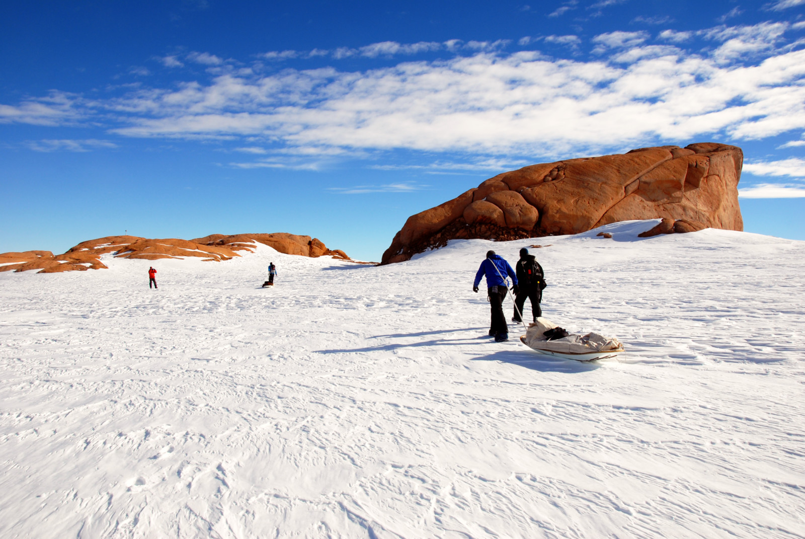
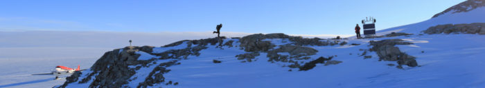
Hauling equipment to install a GPS station on Mount Carbone in the Marie Byrd Land region of West Antarctica. Photo credit: Joel Main
This is the effort that goes into collecting the GPS data from each site in Antarctica, which then becomes open to the public with a simple click of a button from a comfy seat in front of a computer.
I’ve focused on some of the challenges associated with Antarctic field work to provide a glimpse into the effort associated with collecting these data, but make no mistake – the joys are endless. I consider myself exceptionally lucky to have been given the opportunity to deploy and maintain GPS stations in Antarctica. I’ve stepped foot in remote locations throughout the Transantarctic Mountains and West Antarctica, slept in a tent on an ice sheet, held perfectly manicured ice crystals the size of my hand, looked out over breathtaking landscapes and known that I am the only living creature as far as I can see, met and worked with incredible people from all over the world, all while collecting data that will be used to answer critical questions about ice sheets in a warming world. I know I am fortunate to be a part of this project, and I hope the geodetic community feels fortunate to have data from ANET-POLENET, and other projects like it, at their fingertips.
The next time you navigate to a data portal and click the download button, I encourage you take a moment to recognize the efforts of the individuals working behind the scenes to make the data available. For those of you interested in using ANET-POLENET data, head to https://www.unavco.org/data/doi/search/search.html and search for Antarctica-POLENET. If you use ANET POLENET GPS data, please cite it using the DOIs assigned for each Station, following UNAVCO Guidelines (Attribution of Community Data Sets – Link to Guidelines (https://www.unavco.org/community/policies_forms/attribution/attribution.html ). For those interested in seismic data, navigate to the IRIS Metadata Aggregator at http://ds.iris.edu/mda/YT/?timewindow=2007-2018 for access. Finally, examples of the many science results from the ANET-POLENET project may be found here: http://polenet.org/publications
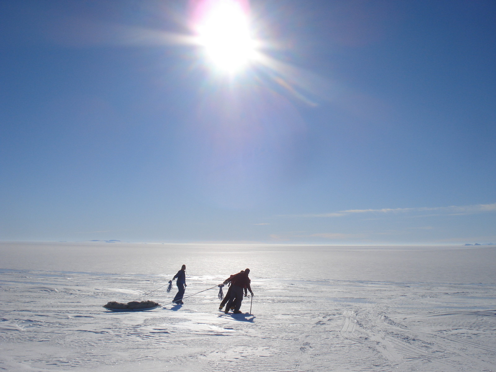
Hauling equipment to install a GPS station in West Antarctica. Photo credit: www.polenet.org