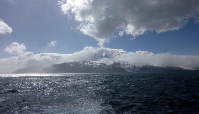
Conference posters: Most scientists spend tens (if not hundreds) of working hours perfecting their conference poster. There’s not just the science to think about, but also the design, the flow, the images, the language… The list is endless. Once complete, you print it, roll it up and feed it into the protective poster tube. Then you travel to the conference venue, whereupon you ‘compete’ with othe ...[Read More]
Seismology
A seismologist on vacation
Beginning of this month, I was travelling to Germany to visit family and friends. One week out of the office, without interpreting wiggles or creating synthetic seismograms. But I bet that most of you know that vacation from science does not really exist, especially if an awesome opportunity comes along… What do seismologists do during their vacation? I was visiting a friend in Göttingen. Ma ...[Read More]
GeoLog
GeoPolicy: How do Members of European Parliament learn about science?
Only ~5% of Members of European Parliament, or MEPs, have a background in the physical sciences1, yet many political challenges require an understanding of the science surrounding these issues. Issues such as locating and extracting mineral resources, understanding climate change impacts, and developing new low-carbon technology. The European Commission (EC) and the European Parliament (EP) have s ...[Read More]
Geology for Global Development
35th International Geological Congress (Cape Town, South Africa)
The past few months have been busy with other work, and unfortunately I’ve not been able to post much on here. I’m hoping to get back to regular posts over the coming weeks, starting with a note on GfGD involvement in the 35th International Geological Congress (IGC) in Cape Town later this month. The IGC takes place every four years, and is a flagship event of the International Union o ...[Read More]
GeoLog
Imaggeo on Mondays: Coastal erosion
Coastlines take a battering from stormy seas, gales, windy conditions and every-day wave action. The combined effect of these processes shapes coastal landscapes across the globe. In calm weather, constructive waves deposit materials eroded elsewhere and transported along the coast line via longshore-drift, onto beaches, thus building them up. Terrestrial material, brought to beaches by rivers and ...[Read More]
Seismology
Paper of the Month — Mapping the upper mantle
“MAPPING THE UPPER MANTLE: THREE-DIMENSIONAL MODELING OF EARTH STRUCTURE BY INVERSION OF SEISMIC WAVEFORMS” (Woodhouse & Dziewonski,1984) commented by Andrew Valentine. Here we are again with our Paper of the Month (PoM) series! Our guest writer is Andrew Valentine, who has chosen to comment one of the landmark papers in global seismic imaging: “Mapping the upper mantle: Thre ...[Read More]
GeoLog
Going deeper underground – why do we want to know how rocks behave?
Imagine you find yourself standing atop a wooden box in the middle of your home town, on a rainy weekend day, with the sole aim of talking to passersby about your research work. It can be a rather daunting prospect! How do you decide what the take-home message of your work is: which single nugget of information do you want members of the public to take away after having spoken to you? Even more im ...[Read More]
Cryospheric Sciences
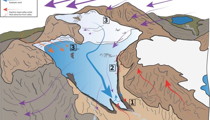
Image of the Week – Hidden Beauty on a Himalayan Glacier
Today’s image of the week comes from stunning setting of Chhota Shigri Glacier in the Pir Panjal Range of northern India. The range is part of the Hindu-Kush Karakorum Himalaya region which is a notoriously challenging place to work as it is very remote and completely inaccessible during the winter months. However, when have these challenges ever stopped a hardy glaciologist?! Our image thi ...[Read More]
GeoLog
Imaggeo on Mondays: Glacier de la Pilatte
The relentless retreat of glaciers, globally, is widely studied and reported. The causes for the loss of these precious landforms are complex and the dynamics which govern them difficult to unravel. So are the consequences and impacts of reduced glacial extent atop the world’s high peaks, as Alexis Merlaud, explains in this week’s edition of Imaggeo on Mondays. This picture was taken on 20 August ...[Read More]
Biogeosciences
Coffee break biogeosciences–in situ sub-millimeter scale resolution imaging of benthic environments
Coral reefs and other benthic marine ecosystems play a very important role in the biogeochemical cycles of our oceans. However, laboratory based study of these environments ranges from being difficult to actually impossible. In order to look at the microscopic-scale processes that occur in the benthic environment a team of scientists developed the Benthic Underwater Microscope (BUM). The device, w ...[Read More]