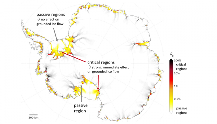
EGU Blogs

Highlights

NH
Natural Hazards

Mapping population dynamics to advance Disaster Risk Management

Mapping population dynamics to advance Disaster Risk Management

  Today we have the honour to introduce Sérgio Freire as our guest. Sérgio Freire is a Geographer, currently working as Scientific/Technical Project Manager at the European Commission’s Joint Research Centre (JRC), Directorate E. Space, Security and Migration, Disaster Risk Management Unit, based in Ispra, Italy. His main activities focus on developing applications of the JRC’s Global Human S ...[Read More]

GeoLog

Imaggeo on Mondays: The ancient guard of Altai

Imaggeo on Mondays: The ancient guard of Altai

In the heart of Eurasia, an ancient stone statue overlooks the expanse of the Kurai Valley and the Altai Mountains in Russia. This relic was crafted more than a thousand years ago, sometime during the 6th or 7th century. A Turkish clan that inhabited the region, known as the First Turkic Khaganat, would often erect stones as monuments of funeral rituals. Natalia Rudaya, who took this photograph, i ...[Read More]

CR
Cryospheric Sciences

Image of the Week – The shape of (frozen sea) water

Image of the Week – The shape of (frozen sea) water

  Polar sea ice exists as isolated units of ice that we describe as floes. These floes do not have a constant shape (see here for instance); they can vary from almost circular to being jagged and rectangular. However, sea ice models currently assume that all floes have the same shape. Much focus has been paid to the size of floes recently, but do we also need to reconsider how floe shape is t ...[Read More]

GeoLog

August GeoRoundUp: the best of the Earth sciences from around the web

August GeoRoundUp: the best of the Earth sciences from around the web

Drawing inspiration from popular stories on our social media channels, major geoscience headlines, as well as unique and quirky research, this monthly column aims to bring you the latest Earth and planetary science news from around the web. Major story The south Indian state of Kerala has suffered unusually heavy monsoon rainfall this month, triggering the worst flooding the state has seen in more ...[Read More]

Earth and Space Science Informatics

Research Software Engineers from the Geosciences assemble for the first time at EGU General Assembly 2018

Research Software Engineers from the Geosciences assemble for the first time at EGU General Assembly 2018

On April 12th 2018, the first Research Software Engineers (RSEs) for geosciences meeting was held at the European Geophysical Union (EGU) General Assembly (GA) in Vienna, Austria. The EGU GA is a huge event with over 15.000 people from more than 100 countries. It has a diverse programme with thousands of posters and hundreds of sessions, but what it lacked was an event to bring together scientists ...[Read More]

CL
Climate: Past, Present & Future

How glowing sediment can help to decipher the Earth’s past climate !

How glowing sediment can help to decipher the Earth’s past climate !

The last 2.5 Million years of the Earth’s history (termed Quaternary) are characterised by climatic cycles oscillating between warm (interglacial) and cold (glacial) periods. To be able to fully understand and interpret past climate variations the development of accurate and precise chronological techniques is crucial. Optically stimulated luminescence (OSL) dating is a strong geochronological too ...[Read More]

GeoLog

Imaggeo on Mondays: Bristlecone pines, some of Earth’s oldest living life forms

Imaggeo on Mondays: Bristlecone pines, some of Earth’s oldest living life forms

About 5,000 years ago, the ancient city Troy was founded, Stonehenge was under construction, and in the rugged Sierra Nevada mountain range, groves of bristlecone pine seedlings began to take root. Many of these pines are still alive today, making them the world’s oldest known living non-clonal life forms. Raphael Knevels, a PhD student from the Friedrich-Schiller-University’s Department of Geogra ...[Read More]

SSP
Stratigraphy, Sedimentology and Palaeontology

The microworld of the past

In my last blog, I described the diverse world of pollen and how palynology – the study pollen, is used in geosciences. Today, I turn to another microcosmos: that of finest layers deposited at the bottom of a lake. A large majority of geoscientists would tell you the best part of their job is field work. Despite sometimes harsh weather conditions, long hikes in wind, rain or merciless sun, many ge ...[Read More]

AS
Atmospheric Sciences

The perfect ice floe

The perfect ice floe

Current position: 89°31.85 N, 62°0.45 E, drifting with a multi-year ice floe (24th August 2018) With a little more than three weeks into the Arctic Ocean 2018 Expedition, the team has found the right ice floe and settled down to routine operations. Finding the perfect ice floe for an interdisciplinary science cruise is not an easy task. The Arctic Ocean 2018 Expedition aims to understand the linka ...[Read More]

NH
Natural Hazards

Bridging the gap between science and decision makers – a new tool for nuclear emergencies affecting food and agriculture

Bridging the gap between science and decision makers – a new tool for nuclear emergencies affecting food and agriculture

The International Atomic Energy Agency (IAEA) has developed an online system to assist in improving the response capabilities of authorities in the event of an emergency caused by natural hazards. This tool provides a clear overview of radioactive contamination of crops and agricultural lands through improved data management and visualization, it also assists in decision support processes by sugge ...[Read More]