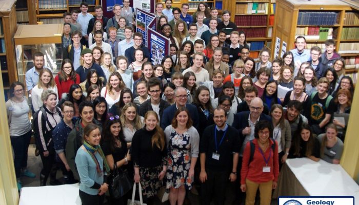
The Greenland Ice Sheet contains enough water to raise sea level by 7.36 meters (Bamber, et. al. 2013) and much of this moves from the interior of the continent into the oceans via Jakobshavn Isbræ – Greenland’s fastest flowing outlet glacier. An ancient river basin hidden beneath the Greenland Ice Sheet, discovered by researchers at the University of Bristol, may help explain the loca ...[Read More]
If you didn't find what you was looking for try searching again.
GeoLog
Finding Funding: a how to guide to applying for research grants
Drafting your first grant proposal can be daunting. Grant writing improves with experience, so how do early career scientists compete on an equal footing with those who are more established? At this year’s General Assembly we tackled this very question at the Finding Funding (SC46) short course. Grant Allen, an atmospheric scientist, who has plenty of experience in applying for funding spoke abo ...[Read More]
Cryospheric Sciences
Marine Ice Sheet Instability “For Dummies”
MISI is a term that is often thrown into dicussions and papers which talk about the contribution of Antarctica to sea-level rise but what does it actually mean and why do we care about it? MISI stands for Marine Ice Sheet Instability. In this article, we are going to attempt to explain this term to you and also show you why it is so important. Background The Antarctic Ice Sheet represents the larg ...[Read More]
Seismology
Paper of the Month — the first of a (hopefully) long series!
“TRIANGULAR DISLOCATION: AN ANALYTICAL, ARTIFACT-FREE SOLUTION” (by Mehdi Nikkhoo and Thomas R. Walter) COMMENTED BY OLAF ZIELKE “Paper of the Month” is a new blog series launched by the ECS-reps team. The aim is to absorb and share the reading experience of mature seismologists with regards to peer-review articles either recently published (less than 12 months) or older, if of particular no ...[Read More]
GeoLog
GeoPolicy: 8 science-based projects improving regions in the EU
As scientists, it can sometimes be difficult to see the real-world implications of some of our research. Concepts can often seem abstract and remote when sitting in a lab or taking field measurements. But researching the Earth sciences can have profound effects on global society. Understanding how the natural world works can help protect and improve human, animal, and plant life. This month’s GeoP ...[Read More]
Cryospheric Sciences
Image of The Week – Ballooning on the Ice
A curious experiment is taking place in Greenland. An experiment involving very large balloons and – of course – a lot of snow. Read on to discover why balloons are an environmentally friendly tool when constructing an ice core drill camp. Last year, a small team traversed 400km from northwest Greenland to the EastGRIP site (read more about the traverse here). This year another strenuous task is w ...[Read More]
WaterUnderground
Protecting springs from groundwater extraction: is a ‘drawdown trigger’ a sensible strategy?
By Matthew Currell – Senior Lecturer at RMIT University Springs, some of which have been flowing for hundreds of thousands of years, have been disappearing in Australia due to human water use over the past century. Following a hotly contested court case, Australia’s Environment Minister imposed a 20cm ‘drawdown limit’ at a set of springs, to protect them from a proposed coal mine. However, this ig ...[Read More]
GeoLog
Volcanic darkness marked the dawn of the Dark Ages
The dawn of the Dark Ages coincided with a volcanic double event – two large eruptions in quick succession. Combined, they had a stronger impact on the Earth’s climate than any other volcanic event – or sequence of events – in the last 1200 years. Historical reports reveal that a mysterious dust cloud dimmed the sun’s rays between in 536 and 537 CE, a time followed by global societal decline. Now, ...[Read More]
GeoLog
Imaggeo on Mondays: Using geophysical techniques to unlock the secrets of the past
Unravelling the secrets of past civilisations is tricky at the best of times. More so if many of the records which hold clues about how communities lived, built their homes and temples, as well as how they fed themselves, were destroyed by subsequent invaders. In these instances, as Felix Rodriguez Cardozo explains in today’s post, geophysical techniques (such as Lidar, which very recently hit the ...[Read More]
Biogeosciences
Keeping a lookout at the edge of the world
Few places in the world conjure up images of remoteness and harshness like Far Eastern Siberia. Yet, it’s places like these where our science is needed most. Arctic soils hold vast amount of carbon, protected in thick layers of permafrost, but these stores are becoming more and more vulnerable as temperatures in the Arctic warm, and are set to warm faster than anywhere else on the planet. R ...[Read More]