The world’s oldest, deepest freshwater lake lies in southeast Siberia: Lake Baikal. Stretching some 600 kilometres across the Russian landscape, Baikal marks what the very early stages of a new ocean – an ancient rift that cleaved the centre of Asia apart throughout the Palaeozoic, Mesozoic and Cenozoic. Today, there are still signs of tectonic activity and the rift continues to diverge 4 mm further apart each year. Much like the East African Rift, Baikal provides scientists with a window into the way oceans are formed.

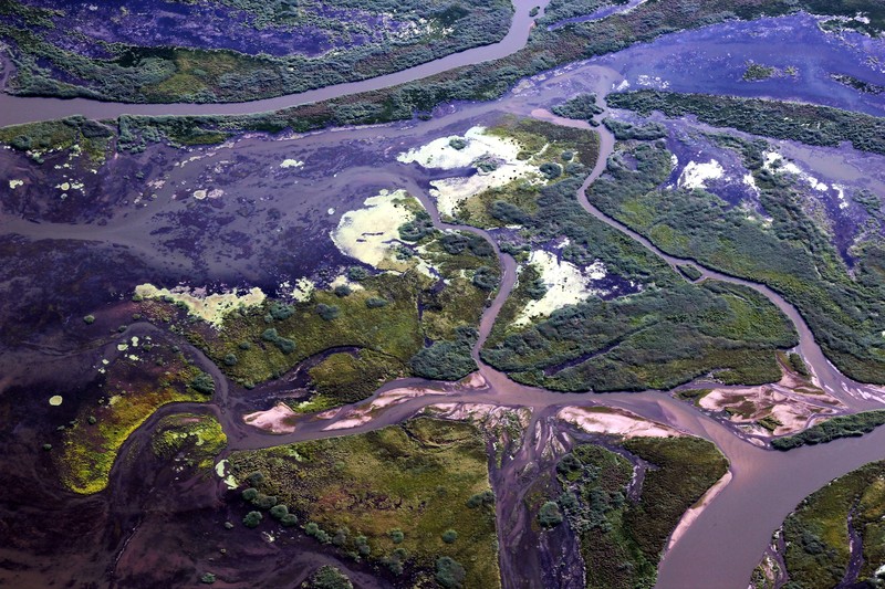
Where the Selenga River meets Lake Baikal. (Credit: Galina Shinkareva via imaggeo.egu.eu)
The Selenga River, which snakes across Asia for over 900 km, brings 30 cubic kilometres of water and more than 3.5 million tonnes of sediment to the basin each year, feeding a rich wetland ecosystem at the northern end of the lake. What’s more, the lake’s age and isolation has led to the establishment of a unique world of underwater flora and fauna – 70% of the lake’s inhabitants are found nowhere else in the world. This combination has earned the lake the nickname ‘The Galapagos of Russia’ and its designation as a World Heritage Site, as well as providing a prime site for evolutionary studies.
Not only that, but the lake is a key spot for climate science too. Baikal’s high latitude location means that it’s particularly sensitive to comate change, leading to numerous investigations into how climate has varied over the last 250,000 years. No doubt we have a lot more to learn from this incredible environment.
By Sara Mynott, EGU Communications Officer
Imaggeo is the EGU’s open access geosciences image repository. Photos uploaded to Imaggeo can be used by scientists, the press and the public provided the original author is credited. Photographers also retain full rights of use, as Imaggeo images are licensed and distributed by the EGU under a Creative Commons licence. You can submit your photos here.


