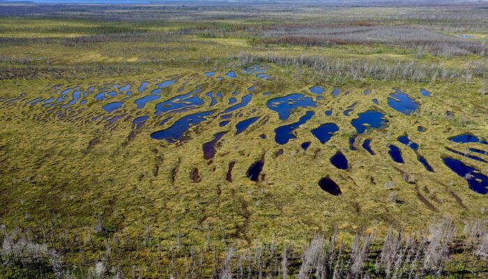
This magnificent pattern is the result of hundreds and hundreds of years of evolution. In this structured minerotrophic peatland in Northern Quebec (Canada), which can also be called a string fen or aapa mire, the green peat ridges (or strings) alternate with water-filled hollows (or flarks). Often flarks are replaced by ponds, which vary in number and size. This pattern of strings and flarks (or ponds) runs perpendicular to the flow of ground water.
Many theories exist to explain the dynamics of this pattern; however, we still do not know the mechanism responsible. Almost all of the present theories suggest that the movement of water could be a major driver of the landscape’s features. The permafrost and frost action, the gradual down-slope slipping, and expansion of peat, the merging of hollows, and fire outbreaks are also considered to be potential factors. Further research is going on to deeply understand the complex relation between abiotic and biotic factors influencing how the string fens take shape.
Vegetation in string fens differs between strings and flarks. Strings are dominated by sedges like Carex exilis, Trichophorum cespitosum, Eriophorum angustifolium, and dwarf birches (Betula glandulosa). On the other hand, flarks or ponds are dominated by Menyanthes trifoliata (also known as bogbean), depending on the level of the water within the ground. The peat moss Sphagnum subfulvum is found on strings while a different species of moss Sphagnum majus can be found on floating mats, at the margin of ponds.
This type of peatland is abundant in the boreal regions of the world, and its predominance can be explained by cooler weather conditions, that limit Sphagnum growth and foster greater surface water flow, especially when the snow melts in the spring.
I encountered this beauty on a field trip during summer of 2016 when I was looking for fens burned by natural wildfires. Unfortunately (or not) this one did not burn, even though all the forests at the margin of the peatland burned pretty heavily. Indeed, the ground of the burned forests was covered by Polytrichum strictum, a pioneer moss known to colonize burned forests or peatland soils (look for the apple green vegetation in the bottom of the photograph).
By Mélina Guêné-Nanchen, Laval University, Québec, Canada
Imaggeo is the EGU’s online open access geosciences image repository. All geoscientists (and others) can submit their photographs and videos to this repository and, since it is open access, these images can be used for free by scientists for their presentations or publications, by educators and the general public, and some images can even be used freely for commercial purposes. Photographers also retain full rights of use, as Imaggeo images are licensed and distributed by the EGU under a Creative Commons licence. Submit your photos at http://imaggeo.egu.eu/upload/.