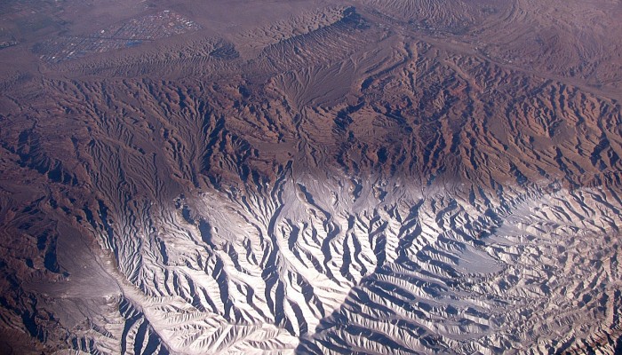
High peaks, winding river channels and a barren landscape all feature in today’s Imaggeo on Mondays image, brought to you by Katja Laute, a geomorphologist from Norway.
This photo was taken from an airplane flying over the Zagros Mountains in Iran. The Zagros Mountain range stretches south and west from the borders of Turkey and Russia to the Persian Gulf, and is Iran’s largest mountain range. The mountain range has a total length of 1500 km and stretches from north eastern Iraq, to the Strait of Hormuz. Many peaks are higher than 2900 m. The tallest mountain is Zard-Kuh at an elevation of 4548 m.
The Zagros fold and thrust belt was formed by the collision of the two tectonic plates- the Iranian Plate and the Arabian Plate. The collision resulted in parallel folds, which are seen as broad anticlines forming the high mountain peaks, , and orogenically are the same age as the Alps. The Zagros Mountains are made up primarily of limestone and dolomite – a sedimentary carbonate rock primarily composed of the anhydrous carbonate mineral of the same name.
The region exemplifies the continental variation of the Mediterranean climate pattern, with a snowy, cold winter and mild rainy spring followed by a dry summer and autumn. In winter, low temperatures can often drop below – 25 °C and many mountain peaks exhibit snow even in summer. The most common ecosystems in the Zagros Mountains are the forest and steppe areas which have a semi-arid temperate climate.
The photo gives an amazing impression of different scales of fluvial dissection. The landscape consists of valleys and their included channels organized into a connecting system known as a drainage network. The powder snow enhances nicely the dendritic drainage pattern.
By Katja Laute, Geomorphologist, Trondheim, Norway
Imaggeo is the EGU’s online open access geosciences image repository. All geoscientists (and others) can submit their photographs and videos to this repository and, since it is open access, these images can be used for free by scientists for their presentations or publications, by educators and the general public, and some images can even be used freely for commercial purposes. Photographers also retain full rights of use, as Imaggeo images are licensed and distributed by the EGU under a Creative Commons licence. Submit your photos at http://imaggeo.egu.eu/upload/.


Pingback: GeoLog | Imaggeo on Mondays: What a thin section has to say about the deformation of the Zagros Mountains
Pingback: GeoLog |