Even within Earth’s more arid environments, you can find life!
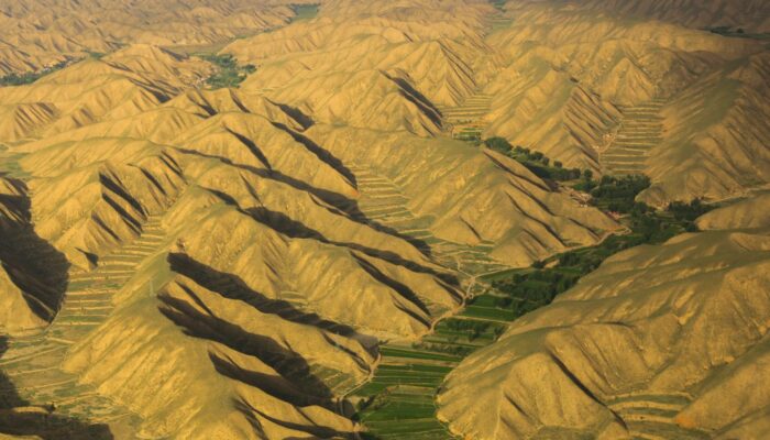
This featured photo was taken near the Lanzhou Zhongchuan Airport, about 50 km away from Lanzhou city, the capital of Gansu province in Western China. The area lies in a region between the Qinghai-Tibet Plateau and the Loess Plateau, with an elevation ranging from 1,500 m to 2,200 m. The landscape is dominated by a network of ridges and valleys; the Loess Plateau in particular is known for its highly erodible soil.
The region is a typical temperate or semi-arid area receiving just 260-290 mm of precipitation annually with a potential evapotranspiration of about 1660 mm each year, according to the Gaolan and Yongdeng National Meteorological Stations. However, even in these dry conditions, you can still find pockets of agricultural plots nestled between the winding mountain ridges. Farmers in this region commonly rely on an agricultural method called terrace farming, where crops are grown on graduated platforms, resembling wide steps. Often used in dry mountainous environments, the practice not only creates a flat surface for farming, but also reduces soil erosion and efficiently conserves water. The terraced farms in this area are mainly distributed in the valley where lands are irrigated for wheat and maize production.
By Olivia Trani, Communications Officer, and Xiaoming Wang, State Key Laboratory of Cryospheric Science, Chinese Academy of Science, Lanzhou, China
Imaggeo is the EGU’s online open access geosciences image repository. All geoscientists (and others) can submit their photographs and videos to this repository and, since it is open access, these images can be used for free by scientists for their presentations or publications, by educators and the general public, and some images can even be used freely for commercial purposes. Photographers also retain full rights of use, as Imaggeo images are licensed and distributed by the EGU under a Creative Commons licence. Submit your photos at http://imaggeo.egu.eu/upload/.


