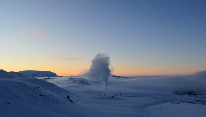
This picture was taken in the Myvatn geothermal area in southeast Iceland. Seeing the geothermal steam vent in this area while the temperature was -22 degrees Celsius is the best experience in Myvatn. The difference between Iceland’s cold ambient temperature and the released heat from inside the Earth is a really stunning event to see.
Iceland is situated in the middle of two tectonic plates (the Eurasian and North American plates) that, through their movement, have led to more than a hundred active and inactive volcanoes in this country. Due to the region’s high volcanic activity and shallow magma chambers, the temperature below Iceland’s surface is generally higher than that of continental areas without volcanoes. These conditions are responsible for the country’s high production of geothermal energy.
This heat can reach the surface in one of two ways. First, heat can naturally escape from the heart of Earth through cracks on the Earth’s surface itself. Second, geothermal powerplants can insert pipes far below the Earth’s surface to capture this heat.
Iceland is known for its geothermal spas, like the famous Blue Lagoon, but additionally, Icelanders use geothermal energy as their main source of heating; in winter, almost 100 percent of the nation’s heating comes from geothermal energy. In the country’s capital Reykjavik, much of the city’s main roads are heated by this source, keeping the streets free from ice and snow. Geothermal energy also accounts for about 25 percent of the island’s electricity.
How is geothermal energy produced? As a heating source, geothermal power plants use a heat exchanger, a pipe that converts the hot water inside the earth into heat. It is then distributed within the steam pipe to residential areas. As an electricity source, power plants capture steam or hot water from geothermal areas to drive electricity generators. The machines convert the heat into electricity, which is then shared with Icelandic neighborhoods.
Because of its investment in a renewable energy source, Iceland is well known as a global leader in sustainability.
By Handriyanti Diah Puspitarini, University of Padova, Italy
Imaggeo is the EGU’s online open access geosciences image repository. All geoscientists (and others) can submit their photographs and videos to this repository and, since it is open access, these images can be used for free by scientists for their presentations or publications, by educators and the general public, and some images can even be used freely for commercial purposes. Photographers also retain full rights of use, as Imaggeo images are licensed and distributed by the EGU under a Creative Commons licence. Submit your photos at http://imaggeo.egu.eu/upload/.


