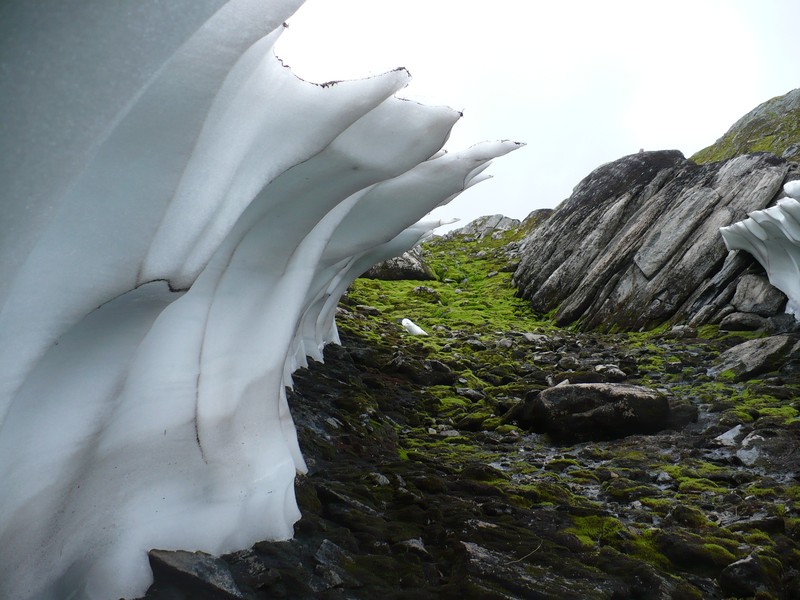
Whilst on a family holiday in Norway, Gerrit de Rooij took this incredible photograph of an ice arch. Understandably geoscience is not his top priority whilst taking photographs on holiday, however Gerrit points out that “pretty much every picture of a landscape has hydrology in there somewhere”, as he goes on to describe below.
This picture was taken near Balestrand, a village along the Sognefjord in Norway (Norway’s largest fjord and the second largest in the world!). The altitude was approximately 900 m above sea level (asl), and not always does all snow vanish during summer over there (we were there in August 2013). What you can see in the picture are the remnants of a much thicker snow pack that covered the stream that trickles down. On the right hand side you can see a glimpse of the other side of the arch that must have gradually been carved out by the stream during the snow melt season (as they call spring over there). Once a tunnel was carved out, thaw took over. The black lines of rock dust on the ridges of the snow arch presumably were left behind by water streaming down along them from the top of the melting snow cover. In the top rim the source of this material is still visible.
Exposed are ancient rocks, heavily eroded by several glaciations and subsequent Holocene freeze-thaw cycles and snow melt flows. The location of the picture is on the west side of Norway’s mountain range. These mountains force western winds from the Atlantic upward, which makes the air cool down and release a lot of its moisture. The very frequent rains (we had 3 rain free days out of 16) create lush vegetation at lower altitudes (the tree line is between 600 and 700 m asl) and sustain extensive moss carpets higher up, as visible in the image. In places where the rock face is too steep to support moss, lichen covers it, which is evidence of very clean air – lichen are highly sensitive to air pollution.
The stream (and many similar streams nearby) feed a small lake that supplies Balestrand with drinking water. The lake can be reached in a day from Balestrand, but hiking further requires an overnight stay, even for most Norwegians, rugged as they may be. There are no huts or any other facilities, so you need to carry your camping gear with you. We camped a little higher without seeing anybody, and from the condition of the trails it was clear that everything beyond the reach of a day trip was used very infrequently. This unperturbed state, the abundant precipitation, and the inertious rocks made the water of the lake crystal clear (several meters of visibility) and very poor in nutrients (hardly any underwater vegetation), making it an excellent source of local drinking water.
In the composition, I liked the two halves of the snow arch mirroring each other, and the fact that the lines and the slope of the large exposed rock face are similar to those in the larger snow arch. The bright green of the moss upslope adds liveliness and draws the eye. I have a relatively simple camera (you want something light when backpacking) and at the time had no software to manipulate my pictures so I had to choose my viewpoint carefully and work with the light that was there. I scooped and stood very close to the snow to create a sense of perspective and have the arch reach over the camera.
By Gerrit de Rooij, Helmholtz Centre for Environmental Research – UFZ, Halle (Saale), Germany
Imaggeo is the EGU’s open access geosciences image repository. Photos uploaded to Imaggeo can be used by scientists, the press and the public provided the original author is credited. Photographers also retain full rights of use, as Imaggeo images are licensed and distributed by the EGU under a Creative Commons licence. You can submit your photos here.


