The latest Geosciences Column features recent research into tsunami hazards and explains how island building out to sea can help protect buildings on the shore…
Barrier reefs are well known for holding off the wrath of the ocean and sheltering the serene lagoons that stretch between them and the mainland. Barrier islands possess the same protective power, taking the impact of waves that have built up across the ocean and dissipating their energy before they break on the continent. Now, a team of Spanish and Columbian scientists have shown how this barrier island effect can be harnessed to protect communities from the worst of ocean waves – the tsunami.
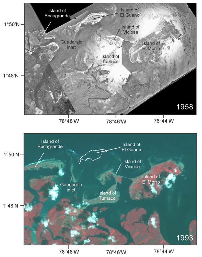
Tsunamis are generated when vertical faults beneath the seabed slip, causing a large earthquake (over magnitude 5 on the Richter scale) and displacing a huge volume of water. They pose a greater hazard than earthquakes alone, and in seismically active coastal areas they are a significant concern. One such area is the seismic belt that shadows the coastline between Ecuador and Columbia, where the Nazca Plate subducts beneath the South American. There have been six major quakes along the belt in the last century, the most recent of which was a magnitude 7.7 quake that resulted in a devastating tsunami and the destruction of an entire island within the Mira River Delta in 1979.
Spot the difference. Top: the island of El Guano prior to the 1979 tsunami; bottom: the same area following the tsunami. (Credit: Otero et al. 2014)
In the Columbian department of Nariño alone, the 1979 tsunami resulted in the loss of over 450 lives and 3080 homes. But the devastation would have been greater if it weren’t for El Guano, a sandy barrier island that was once present just off the country’s Pacific coast. By modelling tsunami as it happened, and how it would unfold if it occurred again today, Luis Otero and his colleagues from the University of Norte, Columbia, and the Environmental Hydraulics Institute IH Cantabria, Spain, showed just how good a barrier the island was – cutting the energy transferred to the island city of Tumaco by up to 60%.
It’s not the first time natural defences have been shown to protect the coast. Indeed, studies of the 2006 Boxing Day tsunami in Indonesia have shown that reefs, mangroves, beaches and dunes all provide the coast some protection by absorbing the tsunami’s initial impact and slowing the speed of the advancing wave.
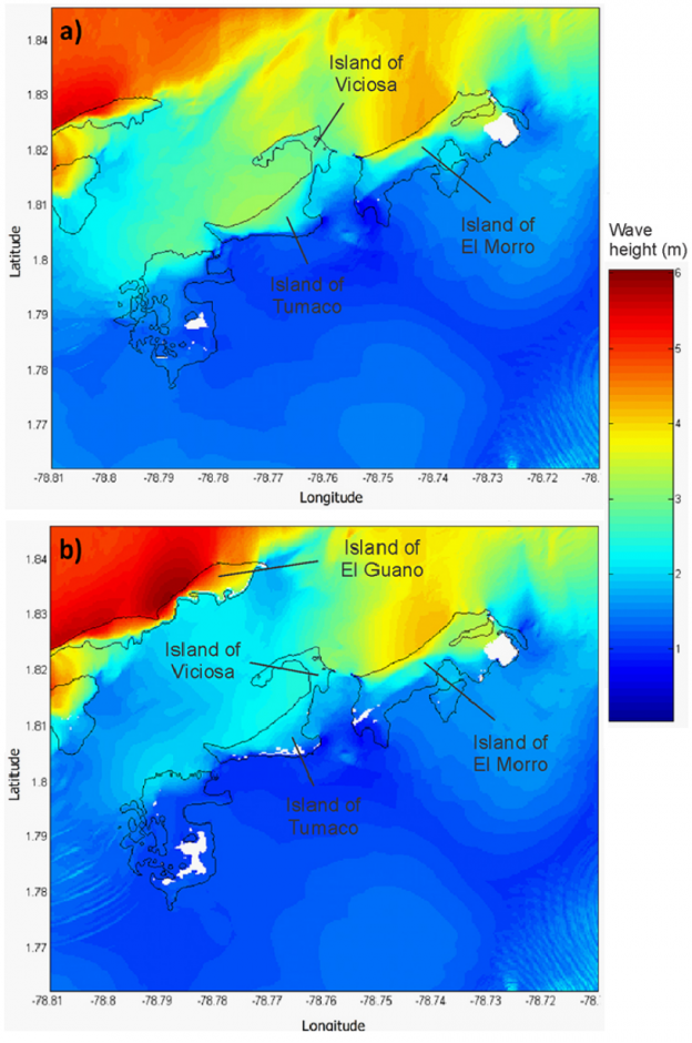
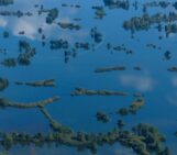
What a difference an island makes: (a) shows the current situation and (b) shows what would happen if the island was present. The white regions represent the areas that are not flooded and the black line shows the shoreline. (adapted from Otero et al. 2014)
Tsunami hazard in this region is both high and likely, and the team show that rebuilding the island would be a worthwhile engineering effort if the government hopes to afford the area the same protection it had in ’79 in the future. Elongating the island would increase its protective potential even further, as would reshaping the it to form three similarly shaped barriers to cut the energy transferred to the Columbian coastline beyond.
Otero’s tsunami model showed such engineering would offer tremendous protection to Tumaco and the other inhabitants of the Mira River Delta in the event of a tsunami – particularly one that occurred at high tide. But because Tumaco is such a sizable coastal city, some unprotected areas would remain.
Currently, the government’s focus is on establishing a swift and effective early warning an evacuation strategy, but a barrier island could provide a big boost to the safety of the local population and the security of local infrastructure.
By Sara Mynott, EGU Communications Officer
Reference:
Otero, L. J., Restrepo, J. C., and Gonzalez, M.: Tsunami hazard assessment in the southern Colombian Pacific basin and a proposal to regenerate a previous barrier island as protection, Nat. Hazards Earth Syst. Sci., 14, 1155-1168, 2014.