Our latest GeoEd article is brought to you by Simon Jung, a lecturer and palaeoceanographer from the University of Edinburgh, who highlights what makes fieldwork a brilliant way to understand Earth processes…
Studying geosciences involves training across a broad range of natural sciences. Only equipped with such background knowledge will students be able to grasp key concepts in the various sub-disciplines that geosciences has to offer. So what’s the best way to get ahold of such knowledge?
A substantial part of the theoretical background in geosciences can be delivered via lectures and/or practicals. Using this standard teaching approach, for example, knowledge of the various rock types and the minerals they contain can be conveyed clearly and effectively. Background information on different soil types, or shapes of rivers, can also be passed on in this fashion.
For something more visual, geological or geomorphological maps can create a great 2D representation of a 3D structure, giving basic insights into the relationship between larger sets of strata or geomorphological features in a given region.
There are, however, important limitations as to the level of understanding students can possibly reach through a classroom-only approach. And these can only be overcome through field training.
Viewing a landscape from an elevated spot – or otherwise suitable location – in the field allows much better comprehension of the processes that have shaped a region. For the first time, truly understanding the nature of the succession of different rock types is an eye-opening and life changing event. Similarly, grasping the role of time in allowing long-term erosion to shape a region can only be attained in the field. A visit to the northwest of Scotland is one way to achieve these goals.
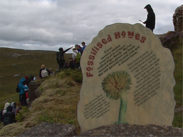
Studying an outcrop in northwest of Scotland. (Credit: Simon Jung)
Geological and geomorphological research in northwest Scotland has been instrumental in laying the foundations of many crucial concepts in geosciences. The area offers easy access to a unique set of rock sequences documenting Scotland’s early geological history, the explosion of life on Earth, as well as how rivers and ice have shaped the modern landscape. Students from the University of Edinburgh are frequently taken out here, where they are exposed to a huge variety of geological and geomorphological phenomena.
The more specific learning outcomes center around three main areas:
- Hands on training in the field helps refining all aspects related to fieldwork (e.g. observational skills, mapping)
- Using self-generated field data regarding rock sequences and their 3D orientation allows students to comprehend the long-term geological history
- Students also obtain a greater understanding of the role of erosion in shaping the landscape in a region. How? By determining river runoff at a number of locations and making measurements of the sediments being transported
Such excursions allow students to develop an improved understanding of the local geological and geomorphological history of a region. At a larger scale, they will also develop a more comprehensive view of the processes having shaped the Earth. As the video below documents, this journey is not only educating, but fun too!
By Simon Jung, Lecturer in Palaeoceanography, University of Edinburgh