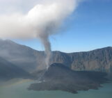
White Island, also known as Whakaari, is an active stratovolcano off the coast of New Zeland’s North Island, nested in the northern end of the Taupo Volcanic Zone. Much of its activity is made up of bubbling mud pools and steamy, sulphurous clouds from fumaroles like the one below – sights that attracts many a tourist to the marine volcano.
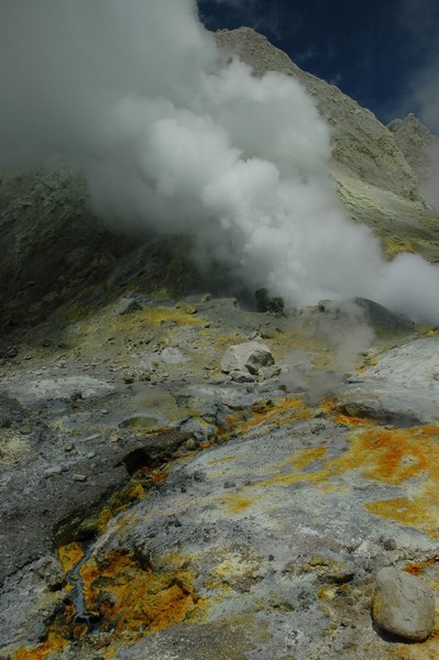
“Geothermal energy live” by J. Florian Wellmann, distributed via imaggeo.egu.eu.
Over the last 200 or so years, a large part of White Island has been peppered with fumaroles like this one – each releasing a variety of volcanic gasses into the atmosphere. Sometimes, though, the island shows signs of real unrest and when a lot of water comes in close proximity to the hot basalt beneath the surface, it rapidly vaporises, resulting in a steam-driven explosion known as a phreatic eruption. These are not something you want to be close to. The force of the water sends blogs of basalt into the air, together with ash and other debris, and the eruption produces high velocity volcanic flows that spread out from the point of the explosion. The last phreatic eruption at White Island occurred in October 2013 and resulted in a new layer of mud being deposited across the crater floor.
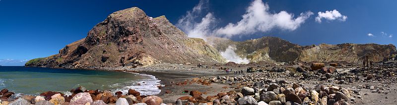
Step back to take in the view – Crater Bay on White Island. (Credit: Javier Sánchez Portero)
GeoNet monitors New Zealand’s volcanoes, White Island among them, so that the authorities can rapidly respond in the event of a disaster. While the volcano isn’t in a phreatic phase, current activity is higher than normal, putting White Island at alert level 1 (on a scale of 1 to 5). You can check out the volcano’s latest activity here – when the sun is up you can see some great images from the volcano-cam, as well as a short and sweet summary of seismic action on the island!
Is the volcano-cam is shrouded in darkness? This footage, which shows some spectacular mud explosions, will make up for it (while you’re behind the safety of your computer screen):
Reference:
Rose, W. I., Chuan, R. L., Giggenbach, W. F., Kyle, P. R., & Symonds, R. B.: Rates of sulfur dioxide and particle emissions from White Island volcano, New Zealand, and an estimate of the total flux of major gaseous species. Bulletin of volcanology, 48, 181-188 (1986).
The EGU’s open access geoscience image repository has a new and improved home at imaggeo.egu.eu! We’ve redesigned the website to give the database a more modern, image-based layout and have implemented a fully responsive page design. This means the new website adapts to the visitor’s screen size and looks good whether you’re using a smartphone, tablet or laptop.
Photos uploaded to Imaggeo are licensed under Creative Commons, meaning they can be used by scientists, the public, and even the press, provided the original author is credited. Further, you can now choose how you would like to licence your work. Users can also connect to Imaggeo through their social media accounts too! Find out more about the relaunch on the EGU website.
