Road cuttings provide a great window into the wonders of what’s beneath the Earth’s surface. In this week’s Imaggeo on Mondays Bahram Sadry takes us through a beautiful fault between Tabriz and Tehran, Iran…
“Road cutting” by Bahram Sadry. Distributed by the EGU under a Creative Commons licence.
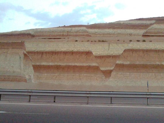
These incredible rock outcroppings along Zanjan-Tabriz highway (the northwest of Iran), are unlike any other outcrop in the world. They are a group of faults and fractures, brecciation and graben that form a part of Iran’s Pliocene-Pleistocene formations. And the diversity of colours in the layers of marls, clays and limestones, sometimes together with gypsum too, are very important for their scientific and educational values, as it is rare you come across such a great textbook example in the field!
This picture shows a normal fault and graben structure. This image was taken as part of a personal project investigating the changes of this outcrop in roadside, through weathering and eroding processes, due to the lack of geo-conservation measures.
Indeed, three years ago, taking inspiration from ecologists, I experimented with using Fixed-point photography in geo-conservation studies in order to monitor the visible changes to the outcrop caused by weathering. Regular travel between Tabriz and Tehran allows me to take repeated photos from this wonderful site.

Normal faults with depressed graben and elevated horst. A graben is produced when two parallel faults cause a block of land to be depressed relative to the surrounding landscape, as you see in this diagram and the photo above. (Credit: Wikimedia Commons user Gregors).
By Bahram N Sadry, The Science and Culture University, Tehran
Bahram Sadry is a lecturer in geotourism and shares his experience of tourism& geology with the wider world on his Geotourism blog.
Imaggeo is the EGU’s open access geosciences image repository. A new and improved Imaggeo site will be launching soon, so you will be able to peruse an even better database of visually stunning geoscience images. Photos uploaded to Imaggeo can be used by scientists, the press and the public provided the original author is credited. Photographers also retain full rights of use, as Imaggeo images are licensed and distributed by the EGU under a Creative Commons licence. You can submit your photos here.