This week’s Imaggeo on Mondays is brought to you by the photographer himself, who describes the striking scenery of the Conwy estuary in Wales…
After a workshop with salt-marsh specialists in Conwy (Wales, UK), I stayed a couple of days to explore the surroundings. Living and working in The Netherlands, for me intertidal areas are typically wide, flat expanses of land, where the horizon is far away and where sand dunes and dikes are the largest vertical elements.
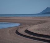
Here in Wales it is a clash of landscapes: ‘hard’, elevated hills that take ages to change from one shape to another, meeting the ‘soft’, low-lying sedimentary environment of the estuary. The town of Conwy adds a human signature to the hills. The tidal range is macrotidal (greater than 4 metres) here, which guarantees beautiful geometries created by the water, such as these tidal creeks in the soft mud. They are only exposed during low tide; and when the tide comes rushing in again, they will once again be covered. The same tide will lift the boats in the background up several metres.
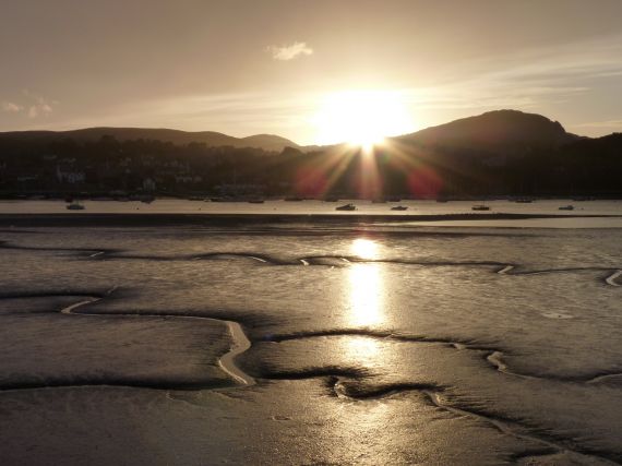
“Low tide at Conwy estuary” by Alma de Groot, distributed by the EGU under a Creative Commons licence.
The intertidal areas are a harsh environment for flora and fauna, as they must be tolerant of exposure to the air and submersion in brackish water. This location is too dynamic and/or too low-lying for saltmarsh plants to establish, but the mudflats will undoubtedly be full of life, containing a banquet of bivalves, crustaceans and polychaetes for coastal birds to feed on.
The town of Conwy is known for its suspension bridge and railway bridge crossing the estuary and the photo is taken close to where a highway is tunnels beneath the estuary. The construction of the tunnel yielded a lot of sediment that needed to be disposed of. The tailings from the tunnel were embanked to create a wetland (outside this photo), now protected by the RSPB. Despite its artificial origins, it now hosts a multitude of birds.
By Alma de Groot, Coastal Researcher, IMARES Wageningen UR
Imaggeo is the EGU’s online open access geosciences image repository. All geoscientists (and others) can submit their images to this repository and since it is open access, these photos can be used by scientists for their presentations or publications as well as by the press and public for educational purposes and otherwise. If you submit your images to Imaggeo, you retain full rights of use, since they are licensed and distributed by the EGU under a Creative Commons licence.