As readers of this blog know, geology is an awe-inspiring subject, dealing as it does with immensely powerful forces operating on time scales, pressures, and temperatures we can barely fathom. It is geological processes that are responsible for the continents, oceans, mountain ranges, indeed for all the landscapes we see around us. Even though many of these processes operate over deep time and deep within the Earth, ingenious researchers have been able to discover a great deal about them. We can place constraints on what happened as far back as the Hadean eon, only a few million years after the Earth was formed. We can determine the composition and approximate motions of material as far down as Earth’s inner core.
In Geology Bites, my aim is two-fold: to present our current knowledge in the words of the researchers pushing the scientific envelope; and to reveal some of the methods that enable us to learn so much. Since my last TS blog post in 2021, Geology Bites has grown to 95 episodes, yet I don’t think I have even scratched the surface of the subject, nor of the wealth of gifted researchers out there.
When preparing an episode, I have an initial conversation with the guest to scope out the subject matter we will focus on in the podcast. Though I already have a topic in mind, it is in this first conversation that I learn if there is a clear story of discovery to be told and, importantly, if it currently animates the researcher. Often, I completely change the topic at this point. For example, I approached Patrick Fulton at Cornell University to talk about the two-mile deep borehole drilled below the campus to assess the viability of geothermal heating. After discussing the Cornell project at some length, we just touched on the temperature observatory he installed in a borehole right across the plate boundary fault off the coast of Japan where the massive 2011 earthquake that caused the devastating tsunami and the Fukushima nuclear disaster occurred. His eyes lit up and we quickly decided to switch to that topic for the podcast. So listeners learn that, amazingly, by measuring a ~0.5 degree C temperature anomaly at the fault zone, he was able to determine a coefficient of dynamic friction on the fault surface of 0.08. This is about an order of magnitude lower than for most rock surfaces and helps explain the large slip at shallow depths of the fault that contributed to the devastating tsunami.
If you haven’t already, try listening to an episode on Geologybites.com, where you can supplement your listening with photos, diagrams, and other visual material that support the podcast. Alternatively, listen wherever you get your podcasts. You can quickly jump to any of the episodes using the index organized by subject area. To whet your appetite, here is a sampling of Geology Bites episodes.
Sara Seager on Exoplanet Geology
It’s quite startling to think that we can learn anything at all about exoplanet geology, given their vast distances from us and their faintness compared to their parent stars. But the combination of powerful space telescopes and ingenious observation techniques are already giving us clues. For example, when we look at the differences in radiation received from the star-planet system when the planet is in transit (either in front of the star or behind it) as compared to non-transiting phases of the planetary orbit, we can isolate planetary surface emission spectra. These contain absorption features that indicate what rock type(s) dominate the planetary surface. The plot shows the a spectrum for exoplanet Kepler-20f modeled by Seager and her colleagues under various assumptions for the dominant surface rock type.
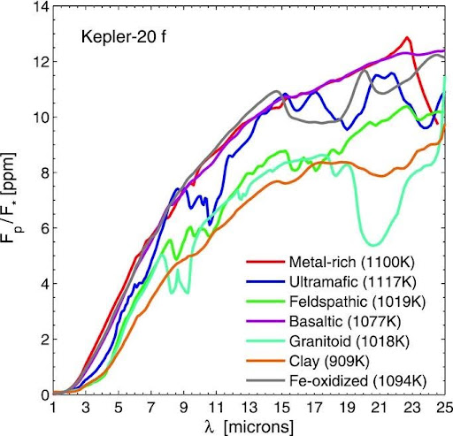
The surface of a rocky exoplanet is expected to show an emission spectrum that has weak absorption features imposed on it. The absorption features are specific to each rock type, which gives us a means of determining what rock type(s) dominate an exoplanetary surface. The plot at right shows a spectrum for exoplanet Kepler-20f modeled by Seager and her colleagues under various assumptions for the dominant surface rock type. The modeled depth of the dip in brightness of the star+planet system (y-axis) is plotted as a function of wavelength (x-axis) when the planet transits behind the star. Hu, R., et al. (2012), The Astrophysical Journal 752, 7
Seager is a Professor of Aeronautics and Astronautics, Professor of Planetary Science, and Professor of Physics at the Massachusetts Institute of Technology. She has just won the prestigious Kavli Prize for her work on detecting and analyzing exoplanet atmospheres.
Damian Nance on What Drives the Supercontinent Cycle
Damian Nance, Distinguished Professor Emeritus at Ohio University, talks about the supercontinent cycle and how recent results from seismic tomography and numerical modeling suggest that the cycle is a manifestation of a process that involves the entire mantle all the way down to the core-mantle boundary.
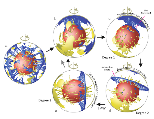
Computer modeling of the evolution of mantle flow patterns discussed in the podcast, with supercontinent assembly occurring above downwelling regions (blue), and supercontinent breakup fostered by mantle plumes in upwelling regions (yellow). The modelling suggests a random mantle circulation when the continents are scattered (a). Mantle convection then tends to evolve to a degree-1 structure with antipodal areas of upwelling and downwelling, and the downwelling leading to the formation of a supercontinent above it (b—>c). Once the supercontinent is formed, subduction of the closing oceans stops, and subduction jumps to the edges of the supercontinent, forming a subduction girdle around it (d). The subduction girdle influences mantle dynamics in such a way as to convert the downwelling beneath the supercontinent into an upwelling, thereby producing a mantle with a degree-2 structure, i.e., one with two antipodal areas of upwelling bisected by a downwelling girdle (d). The dynamical process of true polar wander (TPW) causes the supercontinents, being a region of excess mass, to move towards the equator (d—>e). The upwelling beneath the supercontinent causes it to break up (e), scatter the continents, and eventually return the mantle flow to a degree-1 structure (e—>b). Li, Z.-X., et al. (2009), Physics of Earth and Planetary Interiors 176, 143
Since we’re dealing with many unknowns and small-number statistics (there have only been between three and five supercontinents), this topic involves constructing scenarios that try to be consistent with as many lines of evidence as possible. One fascinating line of reasoning that emerged from the ongoing debate as to whether a supercontinent called Pannotia existed during the interval between Rodinia and Pangea concludes that it is really a cycle of changing deep-mantle convection patterns that is manifested by systematic movement of the continents, and that full assembly of supercontinents may not have to accompany such cycles. I realize this sounds a bit cryptic, but it should become a lot clearer when you listen to the podcast.
Rob Butler on the Origin of the Alps
At the very highest level, the story of the Alps is similar to that of other collisional mountain belts such as the Himalaya. But, in the case of the Western Alps at least, the picture is critically affected by the structure of the southern margin of Europe before the collision. Although it would seem impossible to reconstruct the details of this structure given the subsequent “car crash” between Europe and various continental fragments to the south, Butler explains that we can search for telling clues in the sedimentary rocks surrounding the Alps, such as in the Apennines and in southeast France. Butler is Professor of Tectonics at the University of Aberdeen, Scotland, UK.
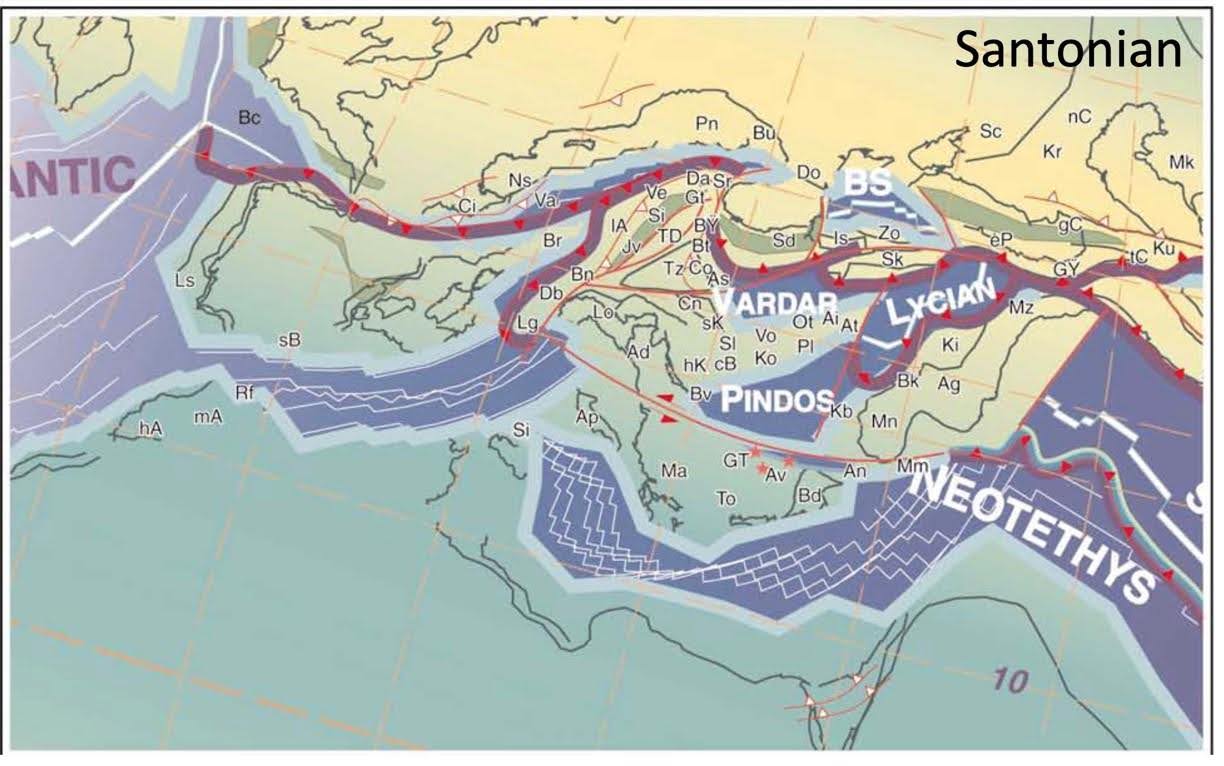
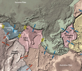
A reconstruction of the paleogeography at the southern margin of Europe for the Santonian age (about 85 million years ago) of the late Cretaceous. Both this reconstruction and the one below show the presence of numerous blocks between Africa and what was to become Europe. The thick purple lines indicate subduction zones with the subducting slab dipping in the direction pointed to by the red triangles. Green/grey bands indicate rift zones. The white labels (e.g., Neotethys) indicate oceans and basins, and the small black legends refer to continental blocks (e.g., Br for Briançonnais), rock formations (e.g., Db for Dent Blanche), rifts (e.g., Sd for the Srednogorie rift-arc), and other geological units. Stampfli, G.M., et al. (2002), Journal of the Virtual Explorer 8:77
Roger Bilham on Himalayan Earthquakes
Until the 2015 Gorkha earthquake in Nepal, there had been a long-standing puzzle as to how very large earthquakes, the so-called megaquakes, could be generated. But satellite radar interferometry showed that much of that earthquake’s movement transferred stored elastic energy from a region below the high Himalaya southwards to a region around Kathmandu. Roger Bilham suggests that a future earthquake that taps into this reservoir could be amplified by it to generate a megaquake. Bilham is Emeritus Professor of Geology at the University of Colorado, Boulder.
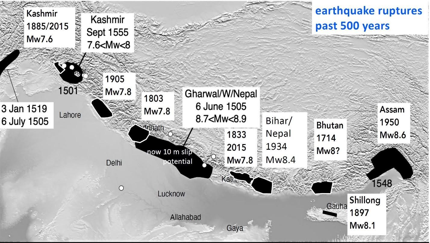
The map shows the locations of recorded Himalayan earthquakes over the past 500 years. Each black blob represents an estimate of the rupture area of the earthquake, i.e., the area of the Himalayan carapace that abruptly moved southwards during the earthquake.