Most of us know about the existence of waves and tides. We can see them along our coasts and, even if we do not pay much attention, we also know that waves and tides move sediment that rests on the seafloor: sand, mud, shells and…plastics.
We all can see ripples and small channels on beaches or estuaries created by the movement of water from waves and tides. If we scuba dive down to a few tens of meters below the sea level, we may see some morphologies that are product of tidal currents and waves, for example submarine dunes and ridges (Figure 1).
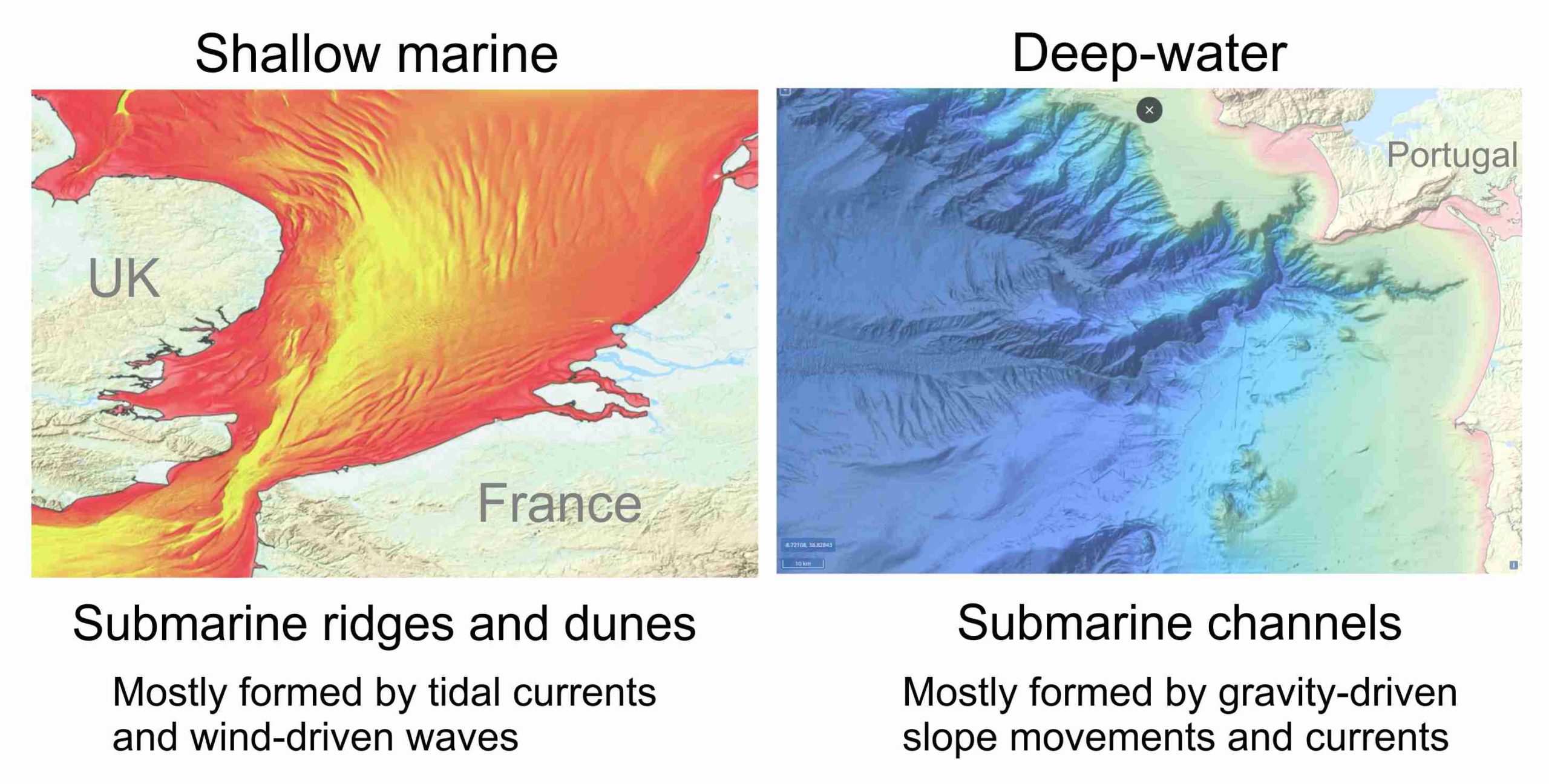
Figure 1 The seafloor morphology: shallow marine versus deep-water.
The shallow marine seafloor is controlled by tidal and wind-driven currents. These typically produce submarine bars and dunes (see the image to the left). The deep-water seafloor is controlled by gravity-driven currents. Submarine channels are probably the most noticeable morphologies product of these types of currents (see the image to the right). Images modified from www.EMODnet.eu.
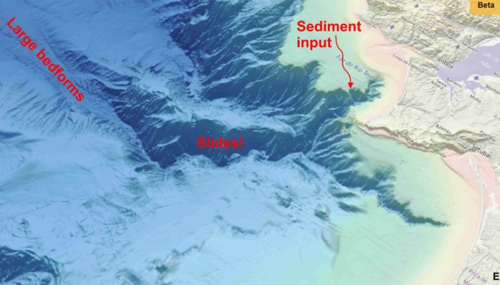
But, is that all there is on the seafloor? What if we move to deeper parts of the seafloor? Many of us have seen maps that depict the general morphology of the Earth seafloor (https://earthobservatory.nasa.gov/images/87189/seafloor-features-are-revealed-by-the-gravity-field). These maps show a very rugged seafloor surface. Using the same terminology created for our continents, we see valleys, mountains, volcanoes and huge depressions. And things get really interesting when looking at high-resolution images from cutting-edge bathymetry surveys in these deep-ocean floors. We see morphologies that look like…rivers! Yes, they do, but they are named ‘submarine channels’ (Figure 1). But, how can this be possible if we are already underwater…rivers inside the ocean? Not quite… The structures that resemble the shape of a river on the sea floor are formed by sediment moving downslope.
We know of various scenarios where relatively large volumes of sediment regularly fall through the sea water column and move downslope over the seafloor just by the effect of the Earth gravitational field. The most common are: (1) sediment input from river discharges in the ocean, (2) collapse of sediment piled up at channel heads or along their first kilometres, (3) inputs of sediment piled up at channel heads by wave and tide related currents, and (4) collapses of relatively large portions of the seafloor by earthquakes. These scenarios result in a wide range of mixtures of different rock types and particle sizes (including human-made rubbish!).
Whatever the mixture of solid materials, the falling sediment particles also displace the very water that surrounds them, pushing it away and pulling it to the same flow direction. This is crucial, because there is a moment when sediment and parts of the surrounding water start to move in the same direction; a sort of mix of water and sediment flow moving independently into the water. You can call this type of current: ‘gravity-driven sediment-laden flow’; but many prefer to call them just ‘turbidity flow or turbidity current’. You will see that flow and current are terms used interchangeably but for ‘flow dynamic’ studies, “flow” is the preferred one.
At the end, both subaqueous currents, like turbidity currents, and flows in rivers affect the substrate in a similar way: they erode and deposit sediment. The water, because of its viscosity, can push and pull particles like mineral clasts or shells as it moves. The latter can also hit other particles pushing them and displacing them to other locations.
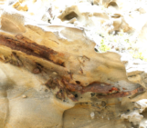
There are also a series of ‘flow phenomena’ that happen both in rivers and submarine channels with similar consequences. The hydraulic jump is one the most effective eroding and depositing sediment among these phenomena. The hydraulic jump results from the complex interaction among gravity field and physical properties of water and solid particles. Simply put, if an accelerating flow that moves downslope is forced to decelerate ‘too fast’, it can develop a localised burst or so-called jump. It is like an upside-down waterfall. The jump looks like a typical breaking wave on a beach, but make no mistake, the fluid dynamics are totally different (Figure 2-1). The water moves upwards in these ‘jumps’, and this causes a negative pressure in the area of the ground beneath the burst. It behaves like a vacuum cleaner, trying to absorb what is on the ground. These hydraulic jumps can create large holes (scours) on the seafloor and incorporate of tons of new sediment within an ongoing current (Figure 2-2). Hydraulic jumps are extremely difficult to observe in subaqueous settings, but recent research efforts in delta-connected submarine channels have recorded sediment movement that agrees with the expected movement of sediment along downslope sections (Figure 2-3).
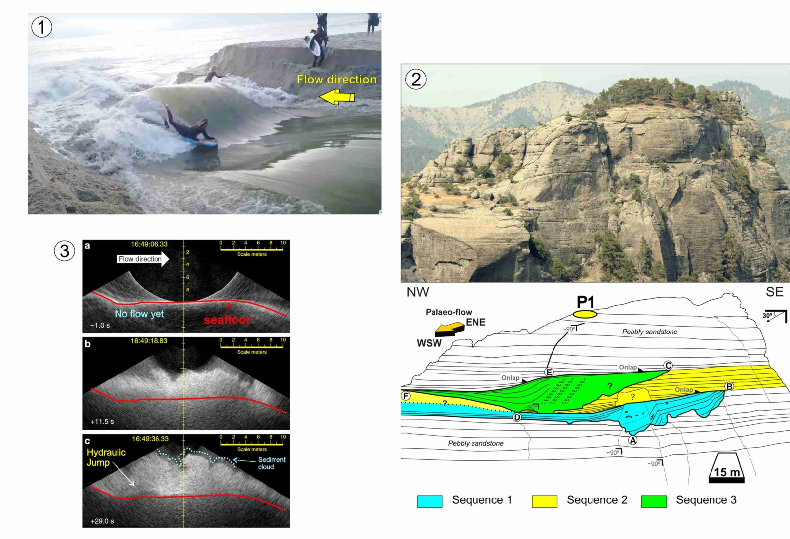
Figure 2 Ongoing hydraulic jumps and their effects in the sedimentary record.
1) A surfer rides the top back of a hydraulic jump formed by a strong current that comes from a lagoon at the right of the image (see full video here: https://youtu.be/eDmoXkF-g9I?t=278). 2) The Alikayasi canyon-fill, part of a submarine channel that existed 12 Ma ago, shows scour and fill architectures that can be explained interpreting the occurrence of powerful hydraulic jumps (see ongoing research here: https://eartharxiv.org/repository/view/1298/). 3) These images show three snapshots of a current that occurred in submarine channels connected to the Squamish River delta. An Acoustic Doppler Current profiler (ADCP) recorded a burst of sediment that formed a cloud with similar 2D morphologies to hydraulic jumps in subaerial environments (see Hughes Clarke, 2016).
Summarising, there are geomorphologies on the deep seafloor similar to continental rivers and produced by processes that share some similarities, but differences can also be significant. We still define many of the processes that transport and deposit sediment in the deep-ocean from a good deal of assumptions. We need to keep going on with research efforts focused in the study the deepest and darkest parts of our oceans. In the next article, we will talk about another type of gravity-driven currents in the ocean that shape the deepest parts of the ocean seafloor: thermohaline currents.
References:

Hughes Clarke, J.E.H., 2016. First wide-angle view of channelized turbidity currents links migrating cyclic steps to flow characteristics. Nature communications, 7(1), pp.1-13.