The conflict between the Israeli state and the Palestinian people revolves not only around the control of land but also extends to the ocean, particularly the sedimentary rocks beneath the seafloor (see oil and natural gas fields in the region in Figure 1). This article aims to analyse the geological aspect, specifically sedimentary rocks with hydrocarbon reservoir potential offshore the Gaza Strip, within the context of the ongoing tragic developments in the region.
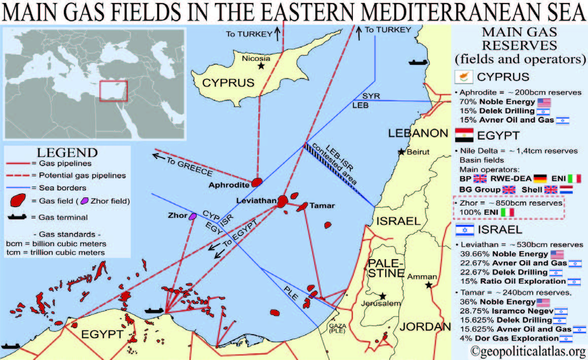
Figure 1. Map with the location of oil and natural gas fields in the Eastern Mediterranean.
From Akarçay and Ak (2019).
The Gaza Marine license, granted in 1999, encompasses the entire marine area off Gaza and was initially awarded to British Gas (BG) and CC Oil & Gas. The gas prospect, discovered using 3D seismic technology in the Levant Basin, is approximately 35 km offshore from Gaza. The exploration well, Gaza Marine-1 (GM-1), drilled in 2000 at a water depth of 603 meters, confirmed commercially viable gas reserves. Subsequently, Gaza Marine-2 (GM-2) well appraised the discovery, estimating reserves exceeding 1 trillion cubic feet at a water depth of 535 meters. After Shell’s acquisition of BG, CC Oil & Gas and the Palestinian Investment Fund acquired Shell’s interest, with each party now holding 50%.
Despite the Oslo Accords granting the Palestinian Authority maritime jurisdiction, Israeli resistance and political complications have hindered the development of these gas fields. Negotiations between BG, the Palestinian Authority, and the Israeli government faced challenges, and attempts to supply gas to Israel were met with obstacles. Today, despite the gas discovery, Gaza Marine’s potential remains untapped, with ongoing battles between those supporting and obstructing development.
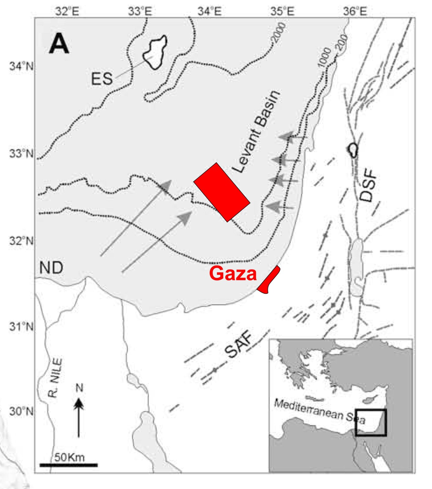
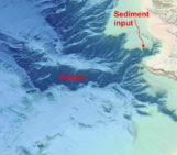
Figure 2. Location of seismic surveys offshore Gaza and Israel in the marine Levant Basin Modified from Clark. and Cartwright, 2009.
Surveys in international waters offshore Gaza reveal submarine channel levee systems within deep-water fold belt settings (Figure 2 and 3). The channel levee systems, typically 500 m wide, exhibit aggradational features with well-developed levee deposits. The presence of underlying faults influences the sinuous planform geometry of channels, resulting in different patterns of channel-fill architectures that impact key elements of reservoir potential: sand body distribution, thickness, and stratigraphic connectivity.
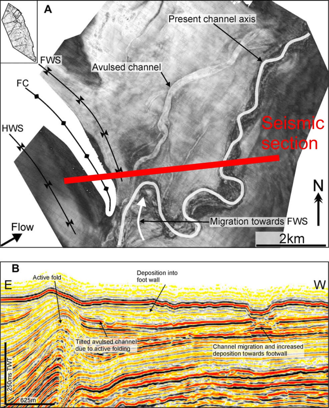
Figure 3. Above, a map illustrating the amplitude of the base surface of channel-fill controlled by a thrust (see location of the seismic line in the red rectangle of figure 2). FWS stands for Footwall syncline, FC for Fold crest, and HWS for Hanging wall syncline. The initial meander of channel-fill exhibits enhanced lateral migration upon exiting the fold belt, moving towards the footwall syncline to the north. In this region, an avulsed channel system forms at the apex of the first outward-facing meander bend following the emergence of the channel-fill from the fold belt. B: Seismic profile displaying heightened tilting of basal channel deposits, contrasting with the undeformed top surface of the channel. Modified from Clark. and Cartwright, 2009.
The Levant Basin, spanning the Eastern Mediterranean’s offshore areas, is estimated to contain 1.7 billion barrels of oil and a staggering 122 trillion cubic feet (Tcf) of natural gas. While global contributions from the Eastern Mediterranean are modest, recent offshore discoveries in Israel and Cyprus underscore the transformative potential of the region. Offshore Gaza, within the promising Levant Basin, has become a focal point for potential hydrocarbon discoveries, shifting attention from historically overshadowed neighbouring basins like the Nile Delta and Western Arabian Province.
The control of gas resources adds complexity to the Israel-Palestine conflict. Israel’s gas power, fuelled by discoveries like Tamar and Leviathan, contrasts with Gaza’s challenges. The occupation hinders Palestinian development in the Gaza Marine area, forcing reliance on imported energy. Despite significant gas discoveries in 2002, like “Gaza Marine” and “Border Field,” disputes and pricing issues have stalled progress. The Gaza gas project could bring economic and environmental gains, reducing dependence on imports. However, disputes and lack of cooperation make tapping these resources for Gazans unlikely in the current state of the Israel-Palestine conflict.
References

Akarçay, p. and Ak, G., 2019. Gas Fields Offshore Gaza Strip: How Sharp Power Threatens Soft Power in the East-Med? Denizcilik ve Deniz Güvenliği Forumu-2019.

Clark, I.R. and Cartwright, J.A., 2009. Interactions between submarine channel systems and deformation in deepwater fold belts: Examples from the Levant Basin, Eastern Mediterranean sea. Marine and Petroleum Geology, 26(8), pp.1465-1482.