Assoc. Prof. Dr Onur Tan from Istanbul University-Cerrahpasa outlines the 6 February 2023 Kahramanmaraş Earthquakes for the Earthquake Watch.
February 6, 2023, was a catastrophic day for Turkey. The most destructive earthquake in the last century, Mw 7.8, hit the eastern part of the country at 04:17 local time. Unexpectedly, the second Mw 7.5 mainshock shook the region nine hours later. The mainshocks destroyed several cities and villages in the 11 provinces, including main large and economically important cities such as Kahramanmaraş, Hatay, Adıyaman, Malatya, Adana and Gaziantep. The latest official information in March 2023 indicates that more than 270 thousand residences and 60 thousand commercial buildings are totally destroyed or highly damaged, and there are more than 60 thousand fatalities.
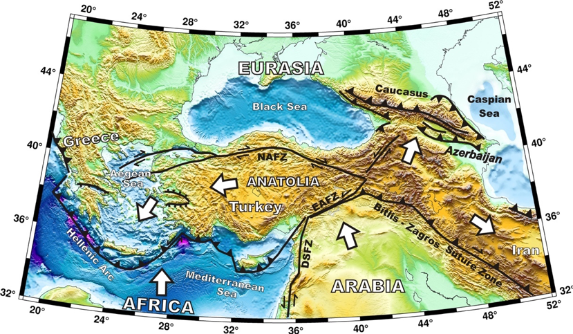
Figure 1. Simplified tectonic map of Turkey and surroundings (modified from Tan, 2021). DSFZ: Dead Sea Fault Zone, EAFZ: East Anatolian Fault Zone, NAFZ: North Anatolian Fault Zone. Triangles indicate the direction of vergence or subduction. Bars are the down-thrown side of normal faults. White arrows are relative plate motions. The relief model is generated with the ETOPO1 model (Amante and Eakins, 2009).
To understand the earthquake hazard in the eastern Mediterranean, we first look at the motion of the tectonic plates in the region. Turkey and its surrounding area are one of the most highly seismically active regions on Earth and are visited by large earthquakes because of its complex tectonic regime. The relative motion of Arabian, Eurasian and African plates generates complex fault systems in Anatolia (Figure 1). The continental collision causes N-S compression in eastern Turkey and transforms faults because of the westward motion of Anatolia with the additional rollback force of the Hellenic subduction. The North Anatolian Fault Zone (NAFZ), which is a plate boundary between Eurasia and Anatolia, extends from the Karlıova Triple Junction in the east to the Aegean Sea in the west for a length of ~1500 km. There were several M>7 destructive earthquakes on the fault. On the other hand, the left-lateral Dead Sea Fault Zone (DSFZ) and the East Anatolian Fault Zone (EAFZ) meet at the Maraş Triple Junction (MTJ) in eastern Turkey (Figure 2; Gulen et al. 1987). The EAFZ extends 600 km from Hatay in the southwest to Karlıova in the northeast and has about seven segments. There are also several left-lateral active strike-slip faults in the region, such as Malatya, Sürgü, Çardak, Savrun and Sarız. Furthermore, the Bitlis-Zagros Suture Zone (BZSZ) is the main thrust boundary between Eurasia and Arabian plates. According to historical records, the region suffers from destructive earthquakes. The 1114 Maraş, 1822 Antakya (Hatay), and 1872 Amik Valey (Antakya) earthquakes are well-known examples.
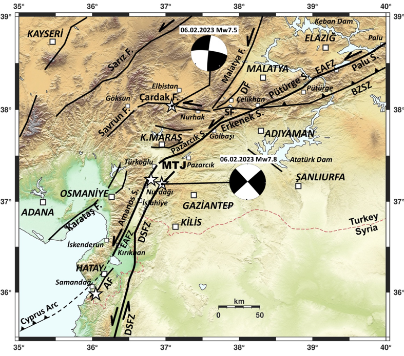
Figure 2. Main tectonic features based on the MTA fault map (Emre et al. 2013; Modified from Tan 2023). Focal mechanism solutions are from USGS. White arrows are plate motions. AF: Antakya Fault, BZSZ: Bitlis-Zagros Suture Zone, DF: Doğanşehir Fault, DSFZ: Dead Sea Fault Zone, EAFZ: East Anatolian Fault Zone, MTJ: Maraş Triple Junction, SF: Sürgü Fault.
The two recent mainshocks ruptured different fault segments on February, 6 (Figure 2). The rupture starting point of the first event with Mw 7.8 is on the northernmost segment of the DSFZ in Nurdağı. The second mainshock with Mw 7.5, ~95 km north of the first, ruptured the Çardak Fault. More than 18 thousand aftershocks were recorded on both faults between 6 February and 19 March 2023. The aftershocks are associated with high location uncertainties (~3-5 km) because of several factors, such as network geometry, phase reading quality, and crustal velocity model (Tan et al. 2011). These were re-analysed to get a clearer image of the activity characteristics. For this aim, the hypoDD algorithm, developed by Waldhauser & Ellsworth (2000), is used to improve absolute hypocentre locations. About 15 thousand events were relocated in Figure 3. The average horizontal and vertical location uncertainties of the events are ±1.2 km and ±2.4 km, respectively (Tan 2023). The hypocentre depths indicate that the width of the seismogenic zone of the Earth’s upper crust is about 20 km.
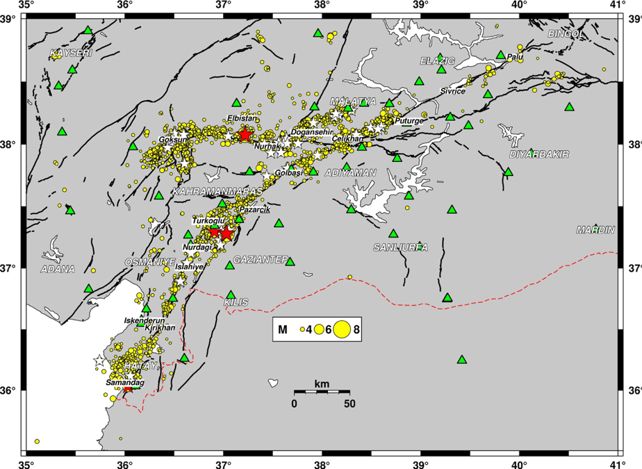
Figure 3. Relocated aftershocks of the Kahramanmaraş mainshocks between 6 February and 19 March 2023. White and yellow stars show events with M 5-6 and M ≥ 6, respectively. Green triangles are seismology stations used in the double-difference algorithm. Black lines are the MTA active faults (Emre et al. 2013).
The aftershocks of the Nurdağı mainshock (Mw 7.8) are on the Amanos, Pazarcık and Erkenek segments of the EAFZ with a total length of ~350 km. Besides, there are many events on the 40 km-length fault segment between the epicentre and MTJ. The first-day activity indicates that the Nurdağı mainshock’s rupture propagates unilaterally towards MTJ at the beginning and then bilaterally along the EAFZ. Independently, the Elbistan mainshock (Mw 7.6) ruptures the east-west left-lateral Çardak Fault. The epicentre is at the centre of the aftershock area, indicating a bilateral rupture propagation. The bending of the left-lateral fault zone around Nurdağı and the high slip patch on the Pazarcık Segment, according to the USGS (2023) finite fault model, increases the stress on the Çardak Fault. This stress load triggered the second mainshock.
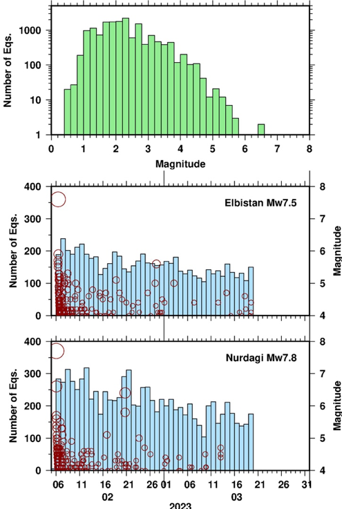
Figure 4. Frequency distributions of the aftershocks between 6 February and 18 March 2023. Top: Magnitude frequency of all events after the mainshocks in logarithmic scale. Middle/Bottom: Daily number of aftershocks for the Elbistan and Nurdağı mainshocks. The magnitudes with M ≥ 4 are also shown.
According to the frequency distributions of the aftershocks in Figure 4, there are a high number of events with magnitudes between 1.0 and 4.0. Although the broad-band station network has the capability of micro-earthquake detection, the small events (M<1) could not be analysed because of the high seismic activity. The daily seismic activity in both ruptured areas decreases slowly with time. This indicates that the aftershocks continue in 2023.
To well understand the characteristics of the large mainshocks and fault systems with reliable seismological information, the continuous aftershock relocation analysis is necessary and must be done carefully to give true knowledge to the Earth Science community.
Acknowledgements
This article is based on the author’s recently submitted paper: Tan (2023). All maps and graphs are plotted with the Generic Mapping Tools (GMT) v4.5 by Wessel and Smith (1998).
References
Amante, C. & Eakins, B.W. (2009). ETOPO1 1 Arc-Minute Global Relief Model: Procedures, Data Sources and Analysis. NOAA Technical Memorandum NESDIS NGDC-24. National Geophysical Data Center, NOAA. doi: 10.7289/V5C8276M [access date August 2020].
Emre, Ö., Duman, T.Y., Özalp, S., Şaroğlu, F., Olgun, Ş., Elmacı, H. & Çan, T. (2018). Active fault database of Turkey. Bulletin of Earthquake Engineering, 16(8), 3229-3275.
Gulen, L., Barka, A. & Toksöz, M. N. (1987). Continental collision and related complex deformation: Maraş triple junction and surrounding structures, SE Turkey. Bulletin for Earth Sciences of Hacettepe University, 14, 319–336.
Tan, O. (2021). A homogeneous earthquake catalogue for Turkey. Natural Hazards and Earth System Sciences, 21(7), 2059-2073.
Tan, O. (2023). Aftershock Properties of the Catastrophic 6 February 2023 Kahramanmaraş (Turkey) Earthquake Sequence. Geophysical Journal International, submitted.
Tan, O., Pabuçcu, Z., Tapırdamaz, M. C., İnan, S., Ergintav, S., Eyidoğan, H., Aksoy, E., and Kuluöztürk, F. (2011). Aftershock study and seismotectonic implications of the 8 March 2010 Kovancılar (Elazığ, Turkey) earthquake (MW = 6.1), Geophys. Res. Lett., 38, L11304, doi:10.1029/2011GL047702.
USGS (2023). Finite Fault models of 06.02.2023 Nurdağı and Ekinözü (Elbistan) earthquakes (model update 21.02.2023, version 4). https://earthquake.usgs.gov/earthquakes/eventpage/us6000jllz/finite-fault, https://earthquake.usgs.gov/earthquakes/eventpage/us6000jlqa/finite-fault. Last visit 28 February 2023.
Waldhauser, F. & Ellsworth, W.L. (2000). A double-difference earthquake location algorithm: Method and application to the northern Hayward fault, California. Bulletin of the seismological society of America, 90(6), 1353-1368.
Wessel, P. & Smith, W.H.F. (1998). New, improved version of the Generic Mapping Tools released. Eos, 79, 579.
This blog post was written by Assoc. Prof. Dr Onur Tan from Istanbul University-Cerrahpasa. It was edited by ECS member Foivos Karakostas.