“SENSOR” – stands for Seismological Experiments, Network Systems, Observations and Recovery
In this blog series, we share news about recent or upcoming seismic experiments around the globe! And this time we’re checking in with Ana Nap, a PhD student from the University of Zurich, Switzerland, about her work on Greenland’s fastest glacier…
Installing instruments on Greenland’s fastest glacier is a great challenge, and recovering them after weeks or months an art. From our fieldwork campaigns in summer 2022 we came back with tons of data – and some impressive images.
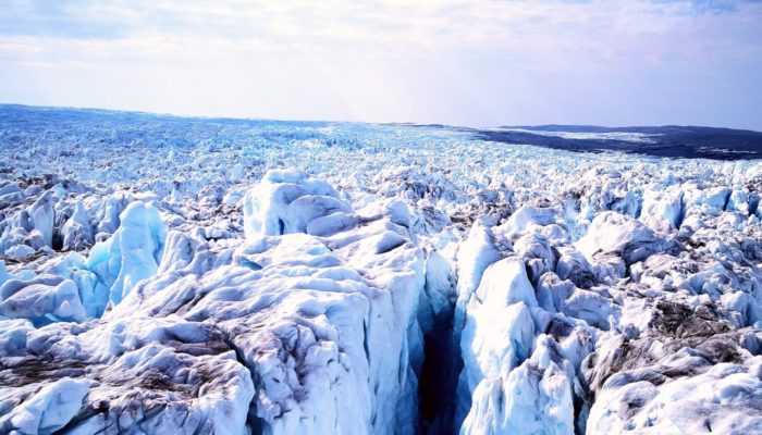
Sermeq Kujalleq in Kangia (also known as Jakobshavn Isbræ) is the fastest flowing outlet glacier in Greenland. At speeds up to 40 meters per day this leads to an intensely crevassed glacier surface. When flying over the ice by helicopter one can see cracks of more than 10 meters wide and nothing but blackness when looking into them. At the front of the glacier cubic-kilometer-sized icebergs break off and fall into the fjord, strongly affecting glacier flow. How exactly fast ice flow, calving and other short-term ice dynamics influence each other is not well-understood, and is exactly what our project aims to investigate.
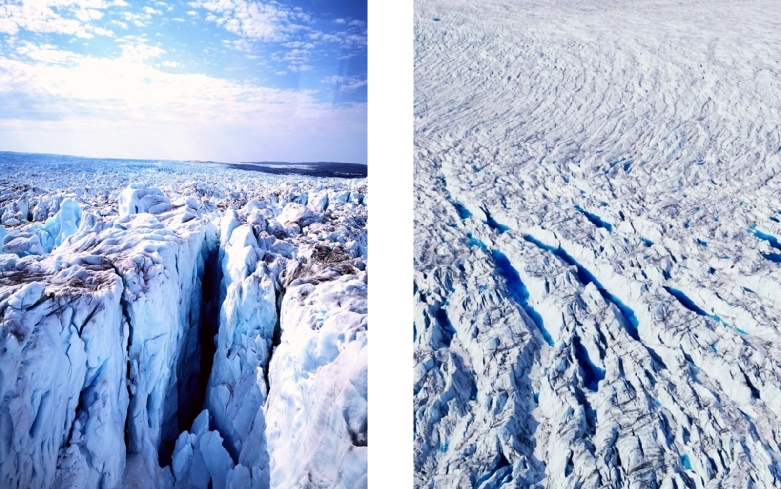
Fig 1: Photos of crevasse and ice surface of Sermeq Kujalleq taken from helicopter Photos: Ana Nap
The COEBELI project
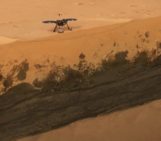
The COEBELI project combines several different measurement techniques for a comprehensive study of short-term ice dynamics at Sermeq Kujalleq in Kangia. We use long-range drone imagery, terrestrial radar interferometry, GNSS, time-lapse cameras and last but not least seismology. The main benefit of complementing the other methods with seismic data is that it allows us to capture signals from processes happening below the ice surface, such as basal sliding, intra-glacial fracturing and several hydrological processes.

Fig 2: Location of field area and aerial photo of Sermeq Kujalleq in Kangia with the 2022 deployment indicated.
The field camp
Many of the measurements, such as the long-range drones, time-lapse cameras and the terrestrial radar, are operated from the field camp during a 3-week period in July 2022. The field camp is set up on a rocky, sandy part of land with a view over the calving front of the glacier. We were flown in by helicopter with all our equipment and all our food. This camp, with four sleeping tents and one kitchen tent, was our home for 3 weeks, with just each other for company and maximum 10°C water ponds for “showering”. Out there, the only contact with the outside world is a satellite phone, which is really only meant for emergencies and contact with Air Greenland for the helicopter logistics. It is a complete break from the habited world that is a rare occasion in our current society. Lots of time to read books (or scientific papers, depending on how much of a workaholic you are 😉 ), play uno, throw some rocks around and just sit, stare into space and enjoy the view.
The camp has an amazing view over the calving front and we were lucky enough to observe some of the majestic calving events that are characteristic for this glacier. The breaking and rotation of huge icebergs was captured simultaneously by all our measurement instruments and time-lapse cameras. One of these events is shown in the movie below (in double speed).
Video 1: A large-scale calving event where ice that was submerged 800 meters deep beneath sea-level races to the surface and collapses spectacularly. Video: Ana Nap
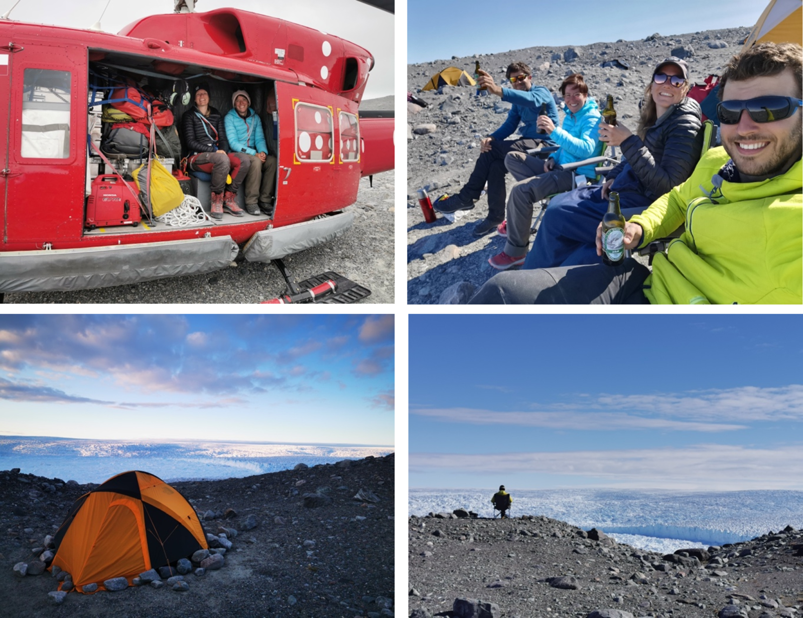
Fig 3 Photos: Ana Nap and Adrien Wehrlé
Top left: The field camp can only be reached by helicopter
Top right: Enjoying some warmth from the sun with an after-work drink. During the field season the sun never fully sets, but at night it still gets significantly colder (<5°C) than during the day (~10-15°C).
Bottom left: The camp area has an extraterrestrial feel to it consisting of mainly rock, sand and dust. And an extraordinary view over the calving front of Sermeq Kujalleq.
Bottom right: Waiting for the next calving event while catching up on some reading.
The seismic deployment
Getting seismic measurements from the fast-flowing trunk of Sermeq Kujalleq was one of the main goals for the 2022 field season. Most of the other measurement techniques can be run from the field camp, but for the GNSS and the seismological measurements we aimed for placing arrays on the glacier itself. The only seismometer on land is one broadband STS2 sensor placed close to camp to record calving events in detail.
For the seismic arrays on the glacier, we had two types of sensors: borehole sensors and self-sufficient seismic-GNSS boxes (SG-boxes). The arrays of borehole seismometers were mostly already deployed during a short field campaign in May 2022 on more accessible parts of the glacier. In these, more upstream parts (see Fig. 2) we could land with the helicopter and walk around a little to drill and deploy the borehole sensors. Also, the glacier is slower in these more upstream parts (> 25 km from calving front) so these arrays of borehole sensors could still be retrieved after a few months. (Although we had some unexpected early snow during the pick-up mission of these borehole sensors in September 2022, so not all have been retrieved yet. But that is another story…)
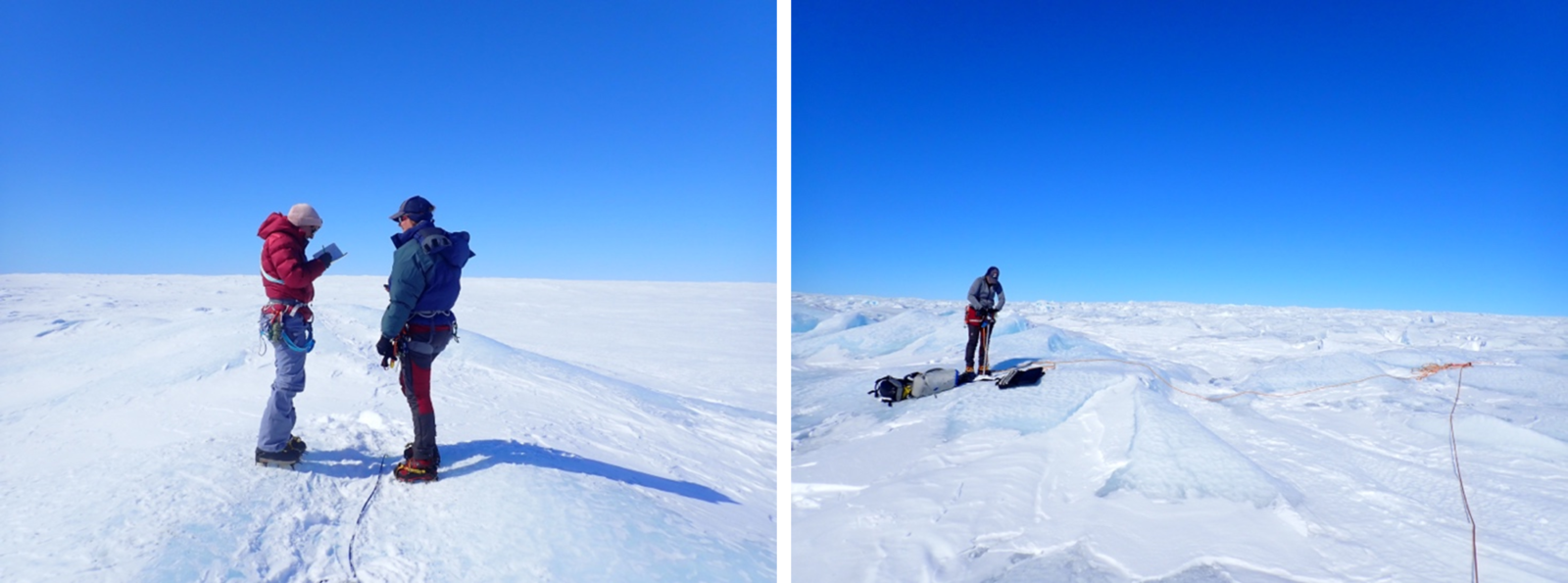
Fig 4: Field campaign in May 2022 where we deployed borehole sensors on the more accessible parts of the glacier ~30 km upstream of the calving front. Photos: Hugo Rousseau
How to: get measurements from places not even a helicopter can land?
–> Fishing them with a rope and ship anchor
For the 3-week summer field campaign in July of 2022, our goal was also to place arrays of geophones closer to the calving front than we placed the borehole arrays (see Fig. 2). As can be seen in the photos from Fig. 1, the surface of the glacier, especially within ~20 km from the calving front, is not a friendly and accessible one. This makes instrumenting these areas very challenging and calls for creative solutions. Therefore, we developed special self-sufficient seismic-GNSS boxes (SG-boxes) that could be lowered and retrieved from a hovering helicopter. These SG-boxes also allowed us to place seismic arrays in the very hard-to-access parts of the glacier. We tested the SG-boxes extensively in 2021 on a Swiss glacier and during a small first deployment in Greenland. The paper on the SG-boxes and their performance can be found here: https://seismica.library.mcgill.ca/article/view/245.
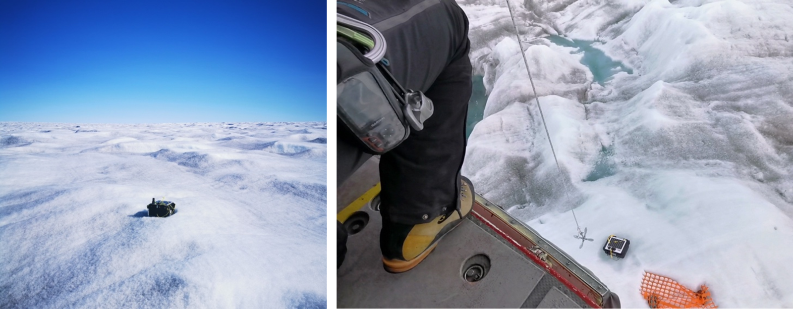
Fig 5: Left: SG-box on the ice. Right: Fishing SG-box and orange tarp from the ice. The orange tarp is so that we can find the SG-boxes back again. Just the black box is very hard to spot when flying over them, even with the GNSS coordinates from the deployment day, as in three weeks the array may have moved up to 250 m downstream.
Deploying these boxes in the most crevassed areas required a very skilled and willing helicopter pilot (with whom we were very lucky), perfect team work and strong nerves.
How we deploy/retrieve these boxes can be seen in the following video:
Video 2: Fishing a sensor box from the hovering helicopter with a small boat anchor on a rope. Video: Ana Nap
In total we successfully deployed 25 stations on the glacier in 2022, both borehole sensors and self-sufficient boxes. Currently, we are analyzing this unique and extensive data set, and we have already detected exciting and unexpected speed variations and seismic events. In the near future we will remain busy with processing all the data and implementing numerical models to understand the many intricately coupled processes that control the fast flow of this glacier.
This blog was written by Ana Nap, a PhD student from the University of Zurich, Switzerland.