For this Earthquake Watch we are very happy to have Yesim Cubuk-Sabuncu write about the seismicity around the recent eruptions in the Reykjanes Peninsula, Iceland! Yesim is a postdoctoral researcher in seismology at the Icelandic Meteorological Office, Service and Research Division since 2019. She obtained her Ph.D. in Geophysical Engineering at the Istanbul Technical University, Turkey in 2016. Let’s dive into it!
Iceland, also known as the land of fire and ice, hosts 32 Holocene volcanoes (Global Volcanism Program, 2023). The Reykjanes Peninsula in southwest Iceland experienced six volcanic eruptions in the last three years. Recently, the town of Grindavík, home to 4,000 people, had to be evacuated in November 2023 due to the formation of a new magmatic dyke. Following that, there were three short-lived volcanic eruptions separated roughly four weeks apart. Lava flows from the last two eruptions destroyed several houses and severely damaged infrastructure, including the main road leading to town.
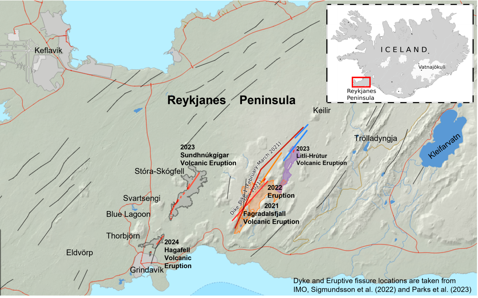
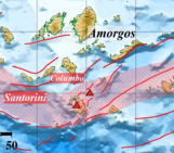
Figure 1: A map providing an overview of volcanic eruptions from 2021 to 2024. The black lines represent fractures in the region, while the red lines indicate the newly developed fissures (2021-2024). Additionally, solid dark red, orange, and blue lines delineate the locations of modeled dykes in Fagradalsfjall and Litli-Hrútur, sourced from IMO, Sigmundsson et al. (2022), and Parks et al. (2023). The colored shaded areas on the map represent the corresponding lava field.
Why are earthquakes and volcanic activity common on the peninsula?
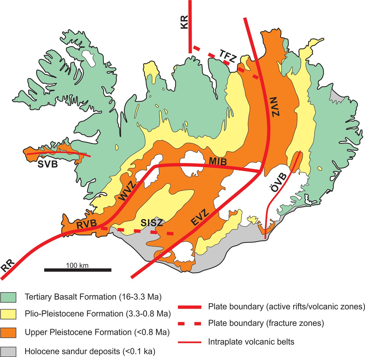
Figure 2: The illustrated map provides an overview of Iceland’s Mid-Atlantic Ridge, a significant plate boundary. Reykjanes Ridge is denoted as RR, and Reykjanes Volcanic Belt is represented by RVB. The other important features include SISZ (South Iceland Seismic Zone), EVZ (East Volcanic Zone), NVZ (North Volcanic Zone), and TFZ (Tjörnes Fracture Zone). Image source: Steemit, modified after Thordarson and Larsen (2007), originally from Sæmundsson (1979).
Iceland has high seismicity and frequent eruptions due to a divergent plate boundary that crosses the country in addition to a mantle plume that is located under the island (Einarsson, 1991a, 2001). As the Mid-Atlantic Ridge separates the North American and Eurasian Plates, the boundary comes onshore at the tip of the Reykjanes Peninsula (RP), forming an oblique spreading ridge- an active zone of volcanism and seismicity on the land (Fig. 2). Active volcanic periods, occurring roughly every thousand years, involve swarm-like earthquake sequences associated with magma movements and fissure openings. A series of N-S directed strike-slip faults, releases stress to accommodate plate motion. As a result, tectonic earthquakes in the range of magnitude 6 can also occur (for example, the 1929 Ms6.5 Brennisteinsfjöll earthquake; Ottósson, 1980). After being dormant since the 13th century ‘Reykjanes Fires,’ the area experienced a new phase of volcanic unrest in early 2020, characterized by rapid uplift, increased seismic activity, and temporal decreases in seismic velocities, indicating that the peninsula was once again awakening.
Monitoring the Recent Seismic Activity
In the Icelandic Met Office (IMO), a dedicated team of natural hazard experts, routinely reviews seismicity. The SIL system, operational in Iceland since the 1990s, provides automated earthquake detection and location estimates. In recent years, we have implemented several cutting-edge techniques to enhance real-time monitoring of seismic and volcanic activity across Iceland. As part of the IS-NOISE project (2018-2021), we applied seismic ambient noise and interferometric techniques to monitor temporal seismic velocity changes (dv/v) for six Icelandic volcanoes using the MSNoise software. Real-time dv/v monitoring revealed a substantial decrease in seismic velocity and strong decorrelation since early 2020, indicating repeated dyke intrusions in the Reykjanes Peninsula (Cubuk-Sabuncu et al., 2021). For the IS-TREMOR project (2021-2024), the network covariance matrix analysis (CovSeisNet) has been incorporated into daily monitoring operations, enhancing seismic tremor detection and recently location. In response to the October 2023 volcanic unrest in the Reykjanes Peninsula, a Distributed Acoustic Sensing (DAS) interrogator has been also deployed by ETH Zurich for real-time monitoring of earthquakes and tremor in collaboration with IMO and HS Orka (an Icelandic geothermal energy company). An existing 8-kilometer-long ‘dark fiber’ telecommunications cable, running through the Svartsengi Geothermal Power Plant towards the west of Grindavík town (Fig. 3), was quickly utilized to collect DAS recordings.
The movie above displays DAS data from the recent Svartsengi-Grindavík unrest, capturing an earthquake quadruplet (a sequence of four earthquakes that occurred within a minute). The live DAS data stream from Blue Lagoon can be found here.

Figure 3: Seismicity map near Svartsengi, Reykjanes Peninsula, depicting rapid NE-SW development of epicenters (M>1) from October 25 to November 28, 2023. Earthquakes are color coded and scaled by magnitude. The reviewed location estimates are used throughout this article unless stated otherwise, but even for the largest earthquakes, the reviewed catalog is still preliminary. Red stars mark M≥4 earthquakes, and the white star indicates the location of the M5.03 earthquake on November 10. The October 25 to November 10 swarm is shown in pink. A purple dashed line denotes the 4-km-long eruptive fissure between Sundhnúkagígar and Stóra-Skógfell. Two DAS cables are shown; Cable-1 recorded the 2021 Fagradalsfjall eruption, and Cable-2 is currently in use for real-time monitoring. The Cable-2 location is approximate.
Eruptions and Seismicity
The 2021-2023 eruptions were each preceded by intense seismic activity, which remarkably abated several days before eruptions began. The area has been shaken by intense low-magnitude earthquake swarms in the order of several tens of thousands of shocks within a few weeks. Magnitudes in the range of M4.0-4.9 were frequently recorded during these sequences. Since October 2020, eleven earthquakes within the range of M5.0-5.7 have occurred, and most of these large events lined up along the plate boundary. The overall seismic activity consists primarily of normal and strike-slip faulting accommodating the opening of the crust as well as releasing of tectonic stress in the area and appears to be triggered by repeated propagation of magmatic material in the shallow crust.
On March 19, 2021, an effusive magmatic eruption began at Fagradalsfjall (Fig. 1), lasting over six-months. For three weeks prior to the eruption, a rapid intrusion of a 9-km-long NE-SW oriented magmatic dyke caused more than 50,000 microearthquakes across the entire peninsula (based on automatic detections). Between February 24 and March 19, 2021 over 60 earthquakes with a magnitude larger than M4 were registered, with at least eight events occurring in the magnitude 5 range. The intense seismicity and deformation declined days before the onset of the eruption (Sigmundsson et al., 2022).
There were five more eruptions! The second eruption took place on August 3, 2022 in Meradalir valley, about a kilometer away from the initial location, and lasted three weeks. The seismic activity began before the eruption, on July 30th, indicating a new dyke intrusion beneath Fagradalsfjall. During the intrusion and eruption period, sixteen events with magnitudes ranging from M4.0 to M4.9 occurred. The next eruption took place on July 10, 2023 at Litli-Hrútur (Figs. 1, 3). About 20 earthquakes with magnitudes greater than 4.0 were recorded during intrusion, with the largest being M5.2 on July 9 at a depth of 5 km (Fig. 4).
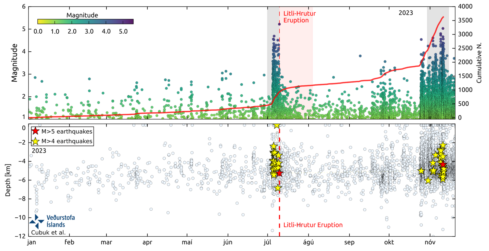
Figure 4: Top panel: Magnitude variation over time for reviewed 2023 events, with the red line showing cumulative earthquake numbers. Dyke intrusion sequences are shaded in gray. The red dashed line marks the beginning of the Litli-Hrútur eruption, while the red shaded area indicates its duration. The bottom panel: Depth distribution of manually reviewed events. Red and yellow stars denote events equal or larger than M5 and M4, respectively. Magnitudes are taken from the IMO reviewed earthquake catalog (last accessed November 20, 2023).
The most recent earthquake swarm in 2023 began on October 25, and approximately 3200 microseismic events occurred over a two-week period based on the manually reviewed earthquake catalog. These events were distributed in a 17-km-wide zone between Stóra-Skógfell in the northeast and Eldvörp in the southwest (Fig. 3). During the two-week swarm, 13 earthquakes with magnitudes exceeding 4.0 were registered, with the two largest earthquakes taking place on November 9th (M4.8 and M4.7) at depths of 3-4 km beneath Mt. Thorbjörn (Figs. 1, 3). From October 25 to November 9, increased seismic activity was concentrated in two zones: a 4 km long NE-SW elongated zone in NE of Grindavík, particularly between Stóra-Skógfell and Sundhnúkagígar, also in the vicinity of Mt. Thorbjörn and Svartsengi (Fig. 3, pink circles). Notably, since 2020, there has been repeated crustal uplift and deformation changes in the vicinity of Svartsengi and Mt. Thorbjörn (Geirsson et al., 2021). Recent deformation measurements (GPS and InSAR) indicated uplift near the same area at the end of October 2023, most likely due to magma accumulation at depth.
On the morning of November 10th, another earthquake swarm started near Sundhnúkagígar, and the swarm peaked that evening, with events rapidly unfolded in a narrow (less than a few kilometers) but 16-km-long NE-SW elongated area, indicating magma intrusion. The epicenters quickly migrated southwards toward Grindavík, triggering a precautionary evacuation of the town. Geodetic models suggested that magma built up beneath Svartsengi and flowed eastward to form the 15-km-long intrusion. The largest event during this sequence was a magnitude of M5.03 earthquake at 4 km depth (Fig. 4). The earthquake frequency and the rate of deformation decreased after 10 days. Eventually, on December 18, approximately two months after the first indications of unrest, a volcanic eruption took place near Sundhnúkagígar (Fig. 1). An hour prior to that, only a minor earthquake swarm had occurred (M3.3 being the largest event) near the eruption site. However, opening of the eruptive fissures have caused significant ground deformation.
In a recurring pattern, the propagation of accumulated magma from the reservoir beneath Svartsengi towards the east resulted in a dyke formation and an effusive eruption within a month, on January 14th, 2024. The deformation data additionally indicated that the origin of magma this time was probably slightly west of its prior location.
The onset of this event was marked by an intense seismicity at the Sundhnúkgígar crater row. Following a magnitude 3.5 earthquake near Hagafell, seismic activity shifted towards Grindavik, indicating magma movements in the area. This led to an eruption near Hagafell, with two eruptive fissures rapidly emerging on the same day, unfortunately causing a lava flow to extend into the town.
Visiting the field
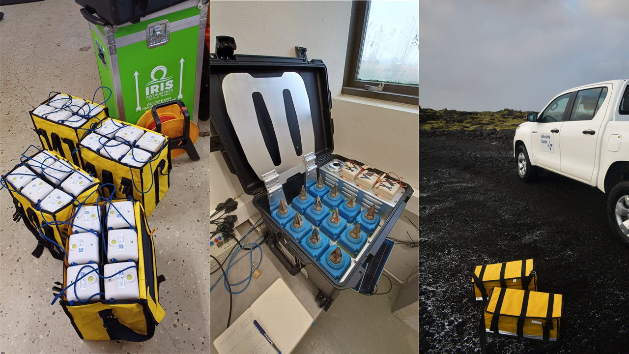
Figure 5: Getting ready for a temporary installation in Svartsengi. The SmartSolo IGU16 1-C nodes are used. Previously, in the spring of 2022, we collected data around the same region using the SmartSolo IGU-16HR 3C, which we rented from the Icelandic equipment pool, LOKI. Photo Credits: Yesim Cubuk Sabuncu
We dedicated a day to installing ten SmartSolo IGU-16 1C nodes provided by the Royal Observatory of Belgium for the IS-TREMOR project to record earthquakes and volcanic tremor (Figs. 5 and 6). Our seismic profile, aligned with DAS Cable-2 (Fig. 3), and continuously records the background seismic field around Svartsengi and Mt. Thorbjörn. The nodes will remain in place until March 2024, and the seismic data collected by the nodes, or ‘minions’, will contribute to better analyze the complex volcano-tectonic events, and tremor locations. Despite Iceland’s recent volcanic history, this is the first time in modern instrumental era that eruptions have occurred on land in the RP! As a result, the wealth of multidisciplinary data accumulated over the past years will greatly improve our understanding of pre-eruptive volcano behavior in the future.
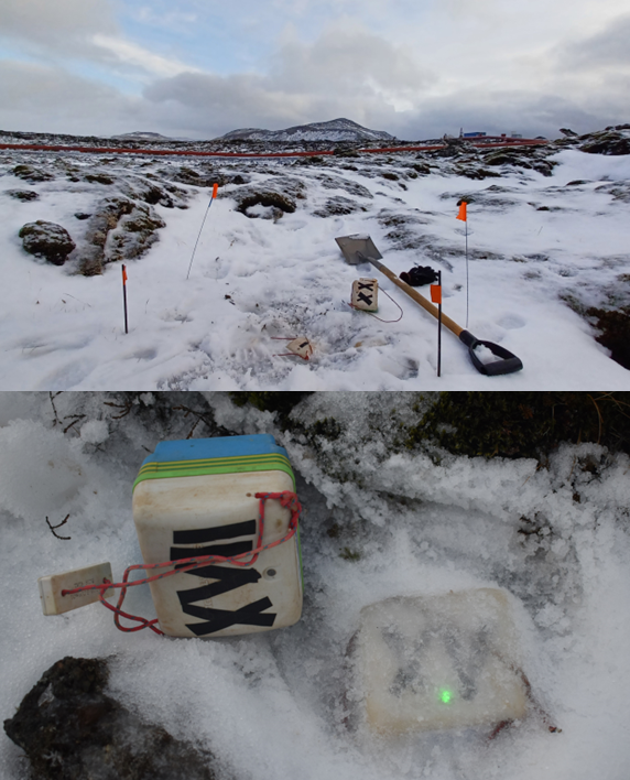
Figure 6: In the field on a freezing cold day. Installing seismic nodes around Mt.Thorbjörn and Svartsengi in collaboration with the Royal Observatory of Belgium, the Icelandic Meteorological Office and the Free University of Brussels. December 2023. Photo Credits: Yesim Cubuk Sabuncu
Acknowledgements
I‘d like to thank the natural hazards monitoring team at IMO for their fantastic work in handling extensive real-time data. We are thankful to the Icelandic Research Fund (RANNIS) for funding our research. The IMO earthquake catalog is accessible at https://skjalftalisa.vedur.is/. The webpages (https://brunnur.vedur.is/gps/reykjanes.html and https://en.vedur.is/about-imo/news/) provide more detailed insights into recent seismicity and deformation patterns in the Reykjanes Peninsula.
The live DAS data from Svartsengi, made accessible through the dedicated works of Sara Klaasen, Andreas Fichtner and Jonas Igel, and others, is publicly available at https://sans.ethz.ch/iceland/. Thanks to the Icelandic Department of Civil Protection for granting us permission to enter the prohibited zone. I express my gratitude to Pálmi Erlendsson for his help during the fieldwork. As the IS-TREMOR project comes to a close, I‘d like to take the opportunity to express my gratitude to my teammates. I cherish their outstanding work, enthusiasm, and friendship that enriched our collaboration.
By Yesim Cubuk-Sabuncu
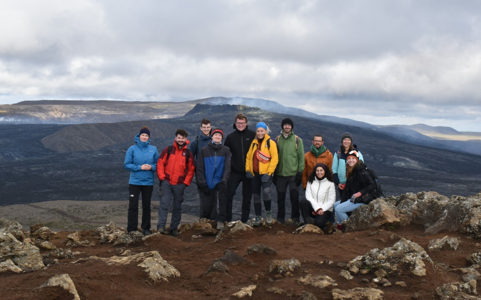
Figure 7: IS-TREMOR extended team visiting the Fagradalsfjall eruption site (yes, we halted the eruption!), September 2021. Photo Credits: Yesim Cubuk Sabuncu
References
Einarsson, P. (2001). Structure and evolution of the Iceland hotspot. Deutsche Geophysikalische Gesellschaft, Mitteilungen, 1/2001, 11–14.
Ottósson, K. G. (1980). Jarðskjálftar á Íslandi 1900–1929 (Earthquakes in Iceland 1900–1929), Tech. Rep. RH-80-05, University of Iceland Science Institute, Reykjavík.
Sæmundsson K. (1979). Outline of the geology of Iceland. Jökull 29, 7-28.
This blog was edited by ECS members Laura Reilly and Katinka Tuinstra. Want to see more ECS activity? Follow us on LinkedIn, Twitter/X, and Instagram.