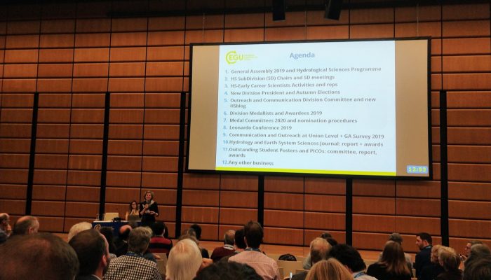
Our image of the week shows the area around the calving front of Petermann Glacier through the spring, summer, and autumn of 2016. Petermann Glacier, in northern Greenland, is one of the largest glaciers of the Greenland Ice Sheet. It terminates in the huge Petermann Fjord, more than 10 km wide, surrounded by 1000 m cliffs and plunging to more than 1100 m below sea level at its deepest point. In 2 ...[Read More]
Geochemistry, Mineralogy, Petrology & Volcanology
Unseen but not unfelt: resilience to persistent volcanic emissions
The last decade has been inundated with reports of environmental disasters impacting the lives of billions of people around the world. While news coverage of floods, hurricanes, earthquakes or wild fires are always accompanied with spectacular images of destruction that emphasise the speed at which they strike, a myriad of slow and latent hazards have been left in the shadow of the public attenti ...[Read More]
Geodynamics
The EUGEN e.V. meeting – a unique (geological) experience
Extracurricular activities for current and former geosciences students provide great value to early career scientists in terms of networking and broadening their scientific horizon. PhD student Maximilian Döhmann, who studies rock deformation with numerical models based on high temperature and pressure torsion experiments in the Geodynamic Modelling group of GFZ Potsdam, shares his experiences wit ...[Read More]
Atmospheric Sciences
Volcanic Ash Particles Hold Clues to Their History and Effects
Volcanic Ash as an Active Agent in the Earth System (VA3): Combining Models and Experiments; Hamburg, Germany, 12–13 September 2016 Volcanic ash is a spectacular companion of volcanic activity that carries valuable information about the subsurface processes. It also poses a range of severe hazards to public health, infrastructure, aviation, and agriculture, and it plays a significant role in bioge ...[Read More]
Cryospheric Sciences
Image of the Week – Powering up the ground in the search for ice
In an earlier post, we talked briefly about below-ground ice and the consequences of its disappearing. However, to estimate the consequences of disappearing ground ice, one has to know that there actually is ice in the area of study. How much ice is there – and where is it? As the name suggests, below-ground ice is not so easy to spot with the naked eye. Using geophysical methods, however, ...[Read More]
Geodynamics
Why there should (not) be more women in geodynamics
Nowadays, equality is cool. Everyone is always going on about how women and men should get the same opportunities. In science, and hence, geodynamics, women are still a bit behind men for both historical (women only recently started graduating more in exact sciences) and unconscious-bias reasons. Therefore, there are lots of programs in order to stimulate women to go into science and, more importa ...[Read More]
Biogeosciences
Investigation of methane emissions in marine systems
Ever wondered how we can measure methane emssions from the seafloor ? And ever wanted to steer a mini submarine remotely operating vehicle (ROV)? Well here´s your chance! Have look at this blog post on analyzing methane emissions using ROVs and you´re ready to embark! The goal is to determine when the gas leak started and how the fluid flow systems work. With our research, we can contribut ...[Read More]
Solar-Terrestrial Sciences
Miho Janvier – The Quest for Solar Storms
In this month’s (first ever for our blog) Life of a Scientist interview, we are very happy to talk to Dr Miho Janvier, a Researcher at the Institut d’Astrophysique Spatiale in Orsay (France), whose work has shed some light on the understanding of solar eruptions and coronal mass ejections (or solar storms) from their birth in the Sun’s corona to their evolution in interplanetary space ...[Read More]
Cryospheric Sciences
Image of the Week – ROVing in the deep…
Robotics has revolutionised ocean observation, allowing for regular high resolution measurements even in remote locations or harsh conditions. But the ice-covered regions remain undersampled, especially the ice-ocean interface, as it is still too risky and complex to pilot instruments in this area. This is why it is exactly the area of interest of the paper from which our Image of the week is take ...[Read More]
Geodynamics
How good were the old forecasts of sea level rise?
The Geodynamics 101 series serves to showcase the diversity of research topics and methods in the geodynamics community in an understandable manner. We welcome all researchers – PhD students to Professors – to introduce their area of expertise in a lighthearted, entertaining manner and touch upon some of the outstanding questions and problems related to their fields. Our latest entry for the serie ...[Read More]