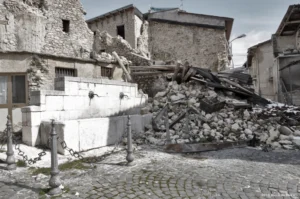

The aftermath of the 28 May 2025 rock-ice avalanche in Blatten, Switzerland. Photo credit: Ulf Büntgen, 2025. Source: Büntgen et al. (2025). CC BY-NC-ND 4.0.
Mountain hazard regimes are fundamentally shifting. There is consensus not just among concerned scientists, but practitioners of risk management, that mountain hazard regimes are affected by warmer temperatures and intensifying precipitation events. The effects of these changes are further amplified by increasing population density in known hazard zones; with more infrastructure and human settlements in mountain regions than any other period in history. This has led to a parallel shift in exposure rates that, coupled with climate-driven changes in hazards, points to increasing risks for communities.
For many hazard types, we often observe increases in the physical hazard and exposure components [2]. Risk results from the interaction of hazard, exposure and vulnerability, with resilience often expressed as the inverse of vulnerability [1]. The risk components of hazard and exposure are increasing when discussing rockfall, debris flow, glacial lake outburst floods (GLOFs), valley flooding and shallow landslides. Some mountain hazards have been argued to remain relatively static when considering climate change, such as snow avalanches [5]. Nonetheless, exposure rates have increased in recent decades for all mountain hazard types on a broad scale [2].
The final element of the basic risk model is vulnerability (or resilience). Communities with better evacuation planning, emergency response, safer vehicles, communication systems, building codes, and hazard monitoring equipment will tend to have lower residual risk [7]. In my professional view, hazard monitoring is one of the most influential elements within the vulnerability component. Monitoring, especially when coupled with forecasting, allows risk managers to pre-emptively close transportation infrastructure, evacuate settlements, and initiate other emergency measures.
In recent years, monitoring technologies have grown exponentially. Wind, temperature and precipitation sensors have become cheaper, more user-friendly and more widely available than ever before. More complex, industry-specific sensors, such as pressure transducers, tensiometers (rock detachment sensors), and radars (mass movement sensors) have become increasingly available and affordable, while simultaneously becoming easier to install and interface with (e.g. LoRA Sensor Products, DecentLab).
Pressure transducers measure physical forces from sudden mass changes and turn them into an electrical signal. They are used to track rising floodwaters, monitor tsunami waves offshore, detect avalanches or debris flow surges in mountain channels, and assess pore-water pressure shifts that trigger landslides. Tensiometers are used on dry mass objects to monitor sudden detachments such as rockfall, bedrock landslides, and sinkholes. Radars are used for both precursory, creeping movements (using GB-inSAR) and sudden releases such as rockfall or avalanches (using Doppler). Long-range Wide Area Networks, called LoRAWAN, have allowed for user-friendly wireless in-field sensing in and around gravitational hazard sites. Such technology offers plug-and-play scenarios for practitioners, who utilise LoRA “gateways”. We are also beginning to see use of satellite Interferometric Synthetic Aperture Radar (InSAR), to actively monitor deformation from space (e.g. USGS InSAR Technique). And, most recently, AI-supported features are being applied to weather networks, hazard forecasting, and mass movement detection (e.g. AI-supported Monitoring, GMD). Specifically, these applications use machine learning techniques to filter false detections, perform image recognition from cameras or satellites, and assist in other quality controls for automated alerting.
But what does all this technology mean for the people who are managing natural risks? Natural risk management is a high-stakes practice. The timely closure of an affected railroad segment under a debris flow channel at the time of an intense rainfall period could save hundreds of lives. For example, knowing when to evacuate a ski tourism settlement before an avalanche hazard peaks following an intense winter storm. In the latter example, waiting too long to evacuate can lead to hazard exposure from traffic congestion. The pressure associated with these decisions can be tremendous and, thus, risk managers increasingly rely on technology to help them make complex decisions. But how do risk professionals decide which technology to use? And where should they implement it? How reliable is it? And perhaps the biggest question: how much should they spend on it?
Monitoring technology at work
Monitoring activities for natural hazard risk management can be broken down to three phases: baseline observation, forecasting and early warning, and event detection—with technology at the foundation of each phase.

If we revisit the experience on 28 May 2025 in Blatten, Switzerland, it was technology that allowed local officials the insight to timely evacuate the village and save nearly 300 lives (cover image) [5]. How did the risk managers know to evacuate before the final catastrophe? Baseline observation of the Kleines Nesthorn mountain was done with simple cameras and GNSS sensors to assess rock movement on and around the toe of the Birch Glacier—directly upslope from the village of Blatten (Fig. 1) [3]. It was then forecasted by local experts that this mass could lead to a catastrophic collapse of the glacier, resulting in a mixed flow of ice, rock, and other debris [6]. At this time, the village of Blatten was evacuated. In the days that followed and before the final collapse of the glacier, additional event detection equipment was deployed: first, in the form of interferometric radar (for slow-moving rock- and ice- creep) and later, Doppler radar (for sudden collapse and flow detection). By timely integrating appropriate hazard monitoring into the risk management workflow, officials avoided a considerably more catastrophic outcome.
In January 2026, the Borough of Juneau, Alaska, entered a state of emergency following unusually heavy snowfall, warming temperatures and a subsequent period of elevated avalanche hazard [8]. A flanking neighborhood of the Borough exists under several large avalanche paths on Mount Juneau. As parts of the settlement were evacuated, a state-of-the-art Doppler radar system was installed at the site to complement existing hazard monitoring technology [8]. The Doppler system, manufactured by a Zurich start-up, gave risk managers greater confidence when deciding to reverse the evacuation protocol. Although Juneau was not struck like Blatten, this case highlights a similar case where risk managers aligned with technology to improve confidence in high-stakes decision making.
AI-integration into existing monitoring technologies
The current moment in the natural hazards monitoring industry is perhaps its most exciting, due to the advent of Artificial Intelligence (AI). AI will help risk managers in each phase of monitoring. For instance, even with limited in-field sensors, AI-supported models are already available to produce inferential observations of precipitation, temperature, wind and snow depth over wide areas. Related AI-driven, machine learning tools are being developed to assist in hazard forecasting and early warning, based on outputs from mentioned AI-models. AI developments are also being made in event detections. For example, an AI feature to a radar detection algorithm may autonomously filter interference from passing helicopters, animals or nearby construction machinery. As these AI-supported algorithms continue to train on real-life detection scenarios, the performance and reliability of existing systems will likely improve.
Industry insights and future direction
This piece was written with mountain hazard risk managers in mind. By highlighting the shifts in risk patterns, we can better understand the additional risks they are managing in the face of climate change. These final thoughts offer professional insight to the current state and future of the natural risk management industry:
AI. AI will almost certainly play an important role in how all natural hazards are assessed, monitored and managed in the future. Although such developments and tools may be valuable, it will remain of highest importance to further develop in-field sensing networks to support all three phases of hazard monitoring. However, it should be abundantly clear to anyone reading this blog that AI will likely not solve the natural risks puzzle for us; we cannot passively rely on AI model conclusions to provide absolute verification of hazard conditions.
Development. Wealthy countries such as Switzerland (Blatten) and the United States (Juneau) are open to develop, fund, and rely on modern hazard monitoring projects to support public risk management. Paradoxically, they are also openly willing to occupy and further develop in hazard zones, often for relatively short-term financial gains (e.g. settlements, mining operations, transportation, and tourism infrastructure).7 It is my opinion that this feedback loop will continue to drive the growth and development of the monitoring technologies sector.
Markets. The present marketplace, limited mostly to Europe and North America, will expand more broadly over the coming decade. Several economic forces such as demand and willingness-to-pay will couple with increasing standards of living, increased exposure rates, reduced technology costs, and better public consciousness around the interplay between climate change and natural hazards; and consequently support the growing monitoring marketplace.
Utility. There is pressure on risk managers to spend money on tools which will prove useful during times of critical hazard. If an avalanche practitioner purchases a monitoring system and very little snowfall occurs the following season, a conclusion may be drawn that the system was not needed. The practitioner must therefore experience periods of “critical hazard” (when avalanches are detected) to validate money spent on the monitoring system.
Value. A risk-cost curve for mountain hazards acknowledges the first ~25% of possible funding can minimise risk by 80%.5 Further, an inflection in the curve indicates a diminishing rate of return on risk reduction after the initial ~10% of possible reduction expenditures.5 The conclusion to these acknowledgements is that the first financial allocations by management efforts are often most impactful. This point creates a spending dilemma for risk practitioners on how to prioritise monitoring against risk engineering infrastructure—deflection dams, roadway barriers or sheds, nets, fences, catchments or other retention installations—which, although at a higher cost, often have a greater impact on residual risk [7].
Rapid technology advancement as a challenge. The growing “toolbox” of devices and software can be overwhelming and lead to indecision on how, what, and when to use monitoring tech to address risk from natural hazards. The onset of AI will likely add further complexity to these decisions. It is important for scientists, researchers and technologists to help narrow a knowledge gap between risk practitioners and available tech resources—achieved through hazard-specific open forums and neutral, third-party risk assessment. Further, practitioners must share their experiences with monitoring technology within local, regional and international circles to achieve consensus on precision workflows to improve public safety and respond appropriately to new tools as they come to market.
References
- Bründl, Michael & Romang, H. & N, Bischof & Rheinberger, Christoph. (2009). The risk concept and its application in natural hazard risk management in Switzerland. Natural Hazards and Earth System Sciences. 9. 10.5194/nhess-9-801-2009.
- IPCC. (2019). High mountain areas. In H.-O. Pörtner, D. C. Roberts, V. Masson-Delmotte, P. Zhai, M. Tignor, E. Poloczanska, K. Mintenbeck, A. Alegría, M. Nicolai, A. Okem, J. Petzold, B. Rama, & N. M. Weyer (Eds.), IPCC special report on the ocean and cryosphere in a changing climate (pp. 131–202). Cambridge University Press.
- Grötsch, A. (2026, May 29). Blatten Kleines Nesthorn.GEOPRÆVENT.https://www.geopraevent.ch/project/blatten-kleines-nesthorn/?lang=en.
- McClure, T. (2025, June 1). ‘This is ground zero for Blatten’: the tiny Swiss village engulfed by a mountain. The Guardian. theguardian.com.
- Noyes, R. (2024). Statistical analysis of avalanche hazard, estimates for residual avalanche risk & economics of alternative management strategies in Stubaital, Tirol [2008 – 2023] (Master’s thesis). University of Innsbruck Digital Library. uibk.ac.at.
- PreventionWeb. (2025). Blatten landslide, Switzerland. preventionweb.net.
- Pfurtscheller, C., Lochner, B., & Thieken, A. H. (2011). Costs of Alpine Hazards (CONHAZ Report WP08_1). University of Innsbruck. Innsbruck, Austria.
- Soliman, A. (2026, January 12). Mount Juneau gets new radar avalanche detection system as Behrends path remains under evacuation advisory. KTOO. ktoo.org
Post edited by: Hedieh Soltanpour, Harriet Thompson and Navakanesh M Batmanathan