Since 15 January 2022, the islands of the Tonga archipelago and surrounding territories have been suffering the effects of what has turned out to be one of the biggest eruptions of this century. The eruption occurred on Hunga Tonga-Hunga Ha’apai, an island created by the emergence of a large submarine volcano. HTHH is located among the ~170 islands of the Kingdom of Tonga and about 65 km north of Tongatapu, the largest island which is host to the capital of the Kingdom of Tonga and represents the most densely populated territory in the archipelago. The eruption damaged the main telephone and internet cable in the area, leaving the islands completely isolated as the disaster struck. The tsunamis generated by the event severely damaged the islands of the archipelago, the worst affected of which was the island of Mango. The tsunami later also reached Japan, and then some portions of the North and South American coasts. Fortunately, many people managed to reach higher ground in time. The death toll so far stands at three people in the kingdom of Tonga and two deaths in Peru. However, more than 80,000 people were severely affected by the event – ash completely covered the islands, crops were destroyed, water supplies were polluted, and the population has been exposed to respiratory risks (Klein 2022, Kusky, 2022, McCall, 2022).
In this post we will try to give you a brief overview of Hunga volcano, previous eruptive activities and the main events surrounding the eruption of 15 January 2022.
A bit of geological background

Fig. 1 – a) geological setting of the Tongan arc (from Brenna et al., 2022); b) Bathymetry of the summit area and caldera of Hunga (from Brenna et al., 2022); c) Tongan volcanic Arc – the red triangles highlight the most recently active submarine and island volcanoes within the Tonga Volcanic Arc, the red rectangle highlights the location of the map (from Plank et al 2020).
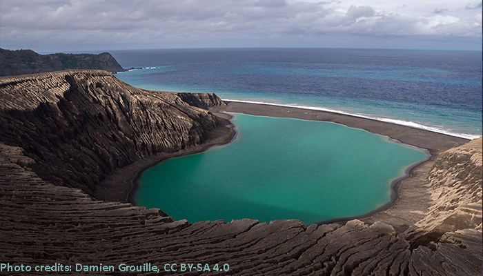
Hunga volcano is located along the Tonga segment of Tonga-Kermadec intra-oceanic arc in the Pacific Ocean (fig.1a and 1c), the arc is the result of the subduction of the Pacific Plate beneath the Indo-Australian Plate (Brenna et al., 2022; Plank et al., 2020; Schellart et al., 2006). This is a huge subduction system extending for 2’550 km between New Zealand and Tonga (Kusky et al., 2022). The volcano, which is more than 1.8 km high and extends for about 20 km across the seafloor, is mostly submerged in the ocean. The top of this colossus is a large caldera (fig.1b), about 5 km in diameter. Only two small ends of this caldera emerged from the water to form the two small uninhabited islands of Hunga Tonga and Tonga Ha’apai (Garvin et al., 2018; NASA Earth Observatory, 2022).
The two islands were connected and joined by a large cone of tephra, which was generated following the 2014/15 eruption, the unified island was named Hunga Tonga-Hunga Ha’apai (Global Volcanism Program, 2015; Brenna et al., 2022; Garvin et al., 2018). After the 15 Jan 2022 main eruption, the island was completely destroyed and only two small portions of the former islands (fig.3d), Hunga Tonga and Hunga Ha’apai emerge from the ocean (NASA Earth Observatory, 2022).
Hunga’s eruptive products are andesitic in composition, which is pretty common for intra-oceanic arcs (Brenna et al., 2022) and as already mentioned it has a caldera-type summit.
What are caldera volcanoes?
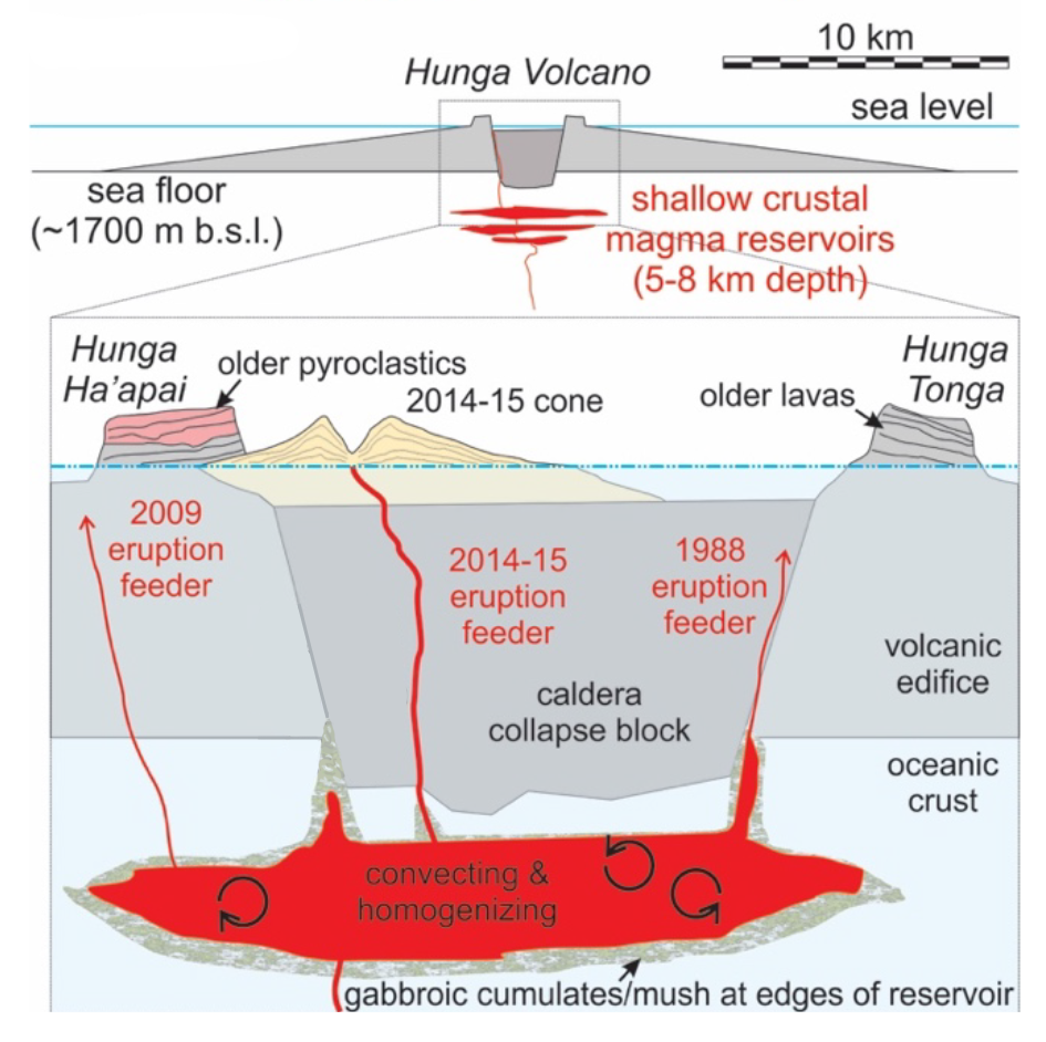
Fig. 2 – Sketch of the Hunga caldera and of the conceptual model of Hunga volcano plumbing geometry, after the 2015 eruption, modified from Brenna et al., 2022.
Calderas are volcanic depressions, more or less circular in form, the diameter of which is many times greater than that of included vents.
The formation of calderas can occur as a result of some form of roof collapse on an underlying shallow magma reservoir, usually following eruptions that involve large magma volumes (Lipman, P. W., 2000). Even if andesitic volcanoes, like Hunga, are commonly associated with the formation of stratovolcanoes, under certain circumstances they might also produce caldera-forming eruptions (Brenna et al., 2022). Caldera-forming eruption are potentially one of the most disastrous events that can affect the Earth. One only has to consider the destructive potential released by Krakatau in 1883, which as a result of the tsunami events it triggered led to the deaths of tens of thousands of people (Lipman, P. W., 2000). This also remember us how important it is to be able to better understand the triggering mechanisms of this type of eruption.
The eruptive history of Hunga volcano
It is not the first time that Hunga violently collapse producing huge eruptions. There seems to be evidence of two other similar episodes, one around AD 1200, and another, older one in AD 200. (Cronin, 2022; Klein 2022; Kusky 2022). This makes the 2022 eruption a once-in-a-millennium event (Klein 2022). Smaller volume eruptions, also known as post-caldera eruptions, can occur between two main caldera-forming events. This is also what we can observe at Hunga, where several smaller eruptions have been produce before the 15 Jan event. The documented ones took place in 1912, 1937, 1988, 2009 and 2014/15 (Kusky 2022; Global Volcanism Program, 2022).
The 2014/15 eruption has been reported in great detail on the Smithsonian Museum Global Volcanism Program website. This eruption was responsible for the formation of a new island, Hunga Tonga-Hunga Ha’apai, and sparked the interest of detailed morphological studies to monitor the erosion processes taking place on the new land. This research may also provide useful material for other future planetary studies. As reported in the article ‘Dramatic Changes at Hunga Tonga-Hunga Ha’apai‘ by NASA Earth observatory, studying the landform evolutions on Earth can also help scientists to better understand and recognize similar features observed on Mars.
This video shows a 3D model of Hunga Tonga-Hunga Ha’apai island made by NASA researchers, after 33 months of high-resolution satellite data, in order to track its evolution through time. Credit: NASA’s Goddard Space Flight Center/LK Ward. Connect article: “NASA Shows New Tongan Island Made of Tuff Stuff, Likely to Persist Years”.
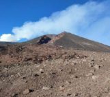
The 2022 Eruption
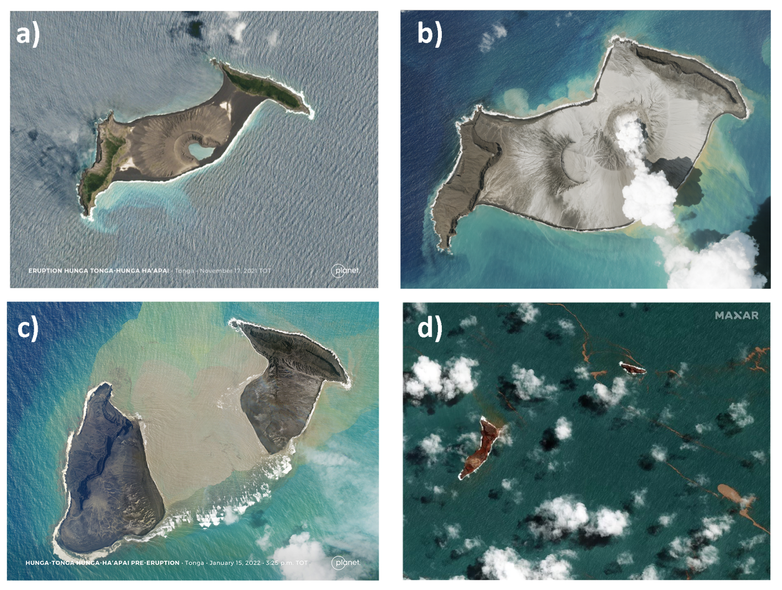
Fig. 3 – Hunga Tonga-Hunga Ha’apai, island captured on: a) November 17, 2021 (image from: © 2021, Planet Labs PBC); b) January 3, 2022 (image from: © 2021, Planet Labs PBC); c) January 15, 2022 (image from: © 2021, Planet Labs PBC);d) January 18, 2022 (image from: Brumfiel article on npr, image credits: Satellite image ©2022 Maxar Technologies)
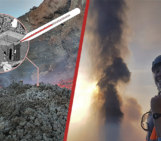
After a pause of about 7 years, the activity at Hunga volcano renewed on December 20th 2021 with a first eruption occurred at 09:35 am, local time. Multiple explosions characterised this first stage and a very high ash plume rose over 15 km above the island.
The eruption continued at low levels in the following days (fig.3b), until the end of the month, with intermittent explosions and then a quiet period for a while. After 2 weeks of calm the activity resumed on January 14th producing a very powerful explosion which erased a large central section of the island (fig.3c). The eruptive plume this time reached 20 km (fig.4). The eruption seemed to have ended, but the main event (fig.5) occurred only the day after on January 15th in the afternoon.
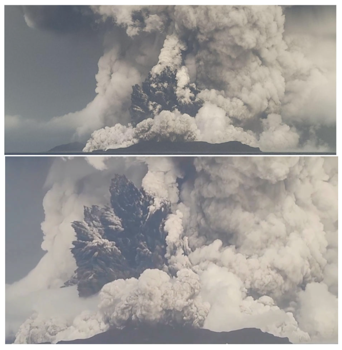
Fig.4 – Image and captions from Kusky 2022: Two photos (taken looking eastward, from Tonga Geological Services) of the eruption at 5:27 p.m. Jan. 14, 2022, with a 5 km wide eruption column rising to 20 km height. Hunga Ha’apai in foreground, Hunga Tonga at far right.
This eruption produced an eruptive column which extended over 30 km in height with some spikes touching the impressive height of 55 km (Andrews, 2022). The explosion sound was heard from Fiji Islands (New Zealand) and managed to reach Alaska, over 9000 km away.
The pressure wave travelled in the atmosphere at the incredible speed of 1000 km/h, and travelled around the globe three times (Andrews, 2022). In comparison, the pressure waves generated by Krakatoa in the 1883 eruption have been recorded passing seven times around the globe (Gabrielson, 2010).
Pressure waves are not the only thing that impressed the researchers, around 400’000 volcanic lightnings have been generated during the eruption (Klein, 2022). The amount of volcanic lightnings produced by the eruptions, starting from Jan 14th, is simply crazy, a very interesting article of Robin George Andrews explores this rather unique event in greater detail, and if you are interested in learning more about volcanic lightnings here, we suggest you take a look at the EGU GMPV post written by Franziska Keller.
Scientist at NASA have estimated the energy released by the event as comparable to something between 4 and 18 megatons of TNT, hundreds of times greater than the energy released by the atomic bomb that exploded in Hiroshima (NASA Earth Observatory, 2022; Brumfiel, 2022). For comparison with a more similar event, the 1883 eruption of Krakatoa was estimated at around 200 megatons (NASA Earth Observatory, 2022).

Fig.5 – Image taken from Kusky 2022: the picture (a) shows a GOES-West satellite image (US National Ocean and Atmospheric Administration) of the sonic blast moving through the expanding eruption column, the picture has been acquired at 5:10 a.m. Jan. 15 GMT (6:10 p.m. local time – Nuku’alofa). The picture (b) is an enhanced image (from Tonga Meteorological Services), showing the location of Tongatapu (the main island of Tonga), and as we can observe, the capital city, Nuku’alofa is located near the center of the blast.
The eruption allows us to observe the first documented, volcanically induced, atmospheric gravity waves formation (Kusky, 2022), an incredible series of concentric and symmetrical atmospheric gravity ripples has been observed from the satellite images acquired via Atmospheric Infrared Sounder (AIRS). (Adam, 2022)
Another side product of the event was sadly the formation of tsunami which caused severe damages in the Tonga’s archipelago (Andrews, 2022; Kusky, 2022). Tsunami waves has been detected also as far as Caribbean Sea (Andrews, 2022). The tsunamis formation caused by this unique event are particularly unusual and require deeper studies to be fully understood.
This is not the only thing that requires more in-depth study, the dynamics that produced and triggered the eruption also require detailed multidisciplinary studies. A really interesting discussion on the possible causes behind the eruption and subsequently behind the tsunami formation is presented in Robin Andrews’ article for Wired: “Scientists Are Racing to Understand the Fury of Tonga’s Volcano“.
The eruption has been widely reported by VolcanoDiscovery.com and the Smithsonian Global Volcanism Project. For those who want to learn more about all the stages step by step, we highly recommend reading these sources. For those who want to listen rather than read, two special episodes of the Volcano Watch the podcast on the eruption have also been released.
References
- Adam, D. (2022). Tonga volcano eruption created puzzling ripples in Earth’s atmosphere. Nature.
- Andrews, R., 2022 (National Geographic 2022, January 16) The Tonga eruption explained, from tsunami warnings to sonic booms. National Geographic.
- Andrews, R., (Wired 2022, January 20) Scientists Are Racing to Understand the Fury of Tonga’s Volcano. Wired.
- Brenna, M., Cronin, S. J., Smith, I. E., Pontesilli, A., Tost, M., Barker, S., … & Vaiomounga, R. (2022). Post-caldera volcanism reveals shallow priming of an intra-ocean arc andesitic caldera: Hunga volcano, Tonga, SW Pacific. Lithos, 106614.
- Brumfiel, G., (NPR 2022, January 18) NASA scientists estimate Tonga blast at 10 megatons. NPR.
- Cronin, S., 2022. Why the Volcanic Eruption in Tonga was so Violent, and What to Expect Next, The Conversation, Jan. 15, 2022.
- Gabrielson, T. B. (2010). Krakatoa and the Royal Society: the Krakatoa explosion of 1883. Acoust. Today, 6(2), 14-18.
- Garvin, J. B., Slayback, D. A., Ferrini, V., Frawley, J., Giguere, C., Asrar, G. R., & Andersen, K. (2018). Monitoring and modeling the rapid evolution of earth’s newest volcanic island: Hunga Tonga Hunga Ha’apai (Tonga) using high spatial resolution satellite observations. Geophysical research letters, 45(8), 3445-3452.
- Global Volcanism Program, 2015. Report on Hunga Tonga-Hunga Ha’apai (Tonga) (Wunderman, R., ed.). Bulletin of the Global Volcanism Network, 40:1. Smithsonian Institution.
- Global Volcanism Program, 2022. Hunga Tonga-Hunga Ha’apai (Tonga) Eruptive History.
- Global Volcanism Program, 2022. Report on Hunga Tonga-Hunga Ha’apai (Tonga). In: Sennert, S K (ed.), Weekly Volcanic Activity Report, 19 January-25 January 2022. Smithsonian Institution and US Geological Survey.
- Klein, A. (2022). Tongan volcano erupts.
- Kusky, T. M. (2022). Déjà vu: Might Future Eruptions of Hunga Tonga-Hunga Ha’apai Volcano be a Repeat of the Devastating Eruption of Santorini, Greece (1650 BC)?. Journal of Earth Science, 1-7.
- Lipman, P. W. (2000). Calderas. Encyclopedia of volcanoes, 643-662.
- McCall, C. (2022). Tonga disaster health response accelerates. The Lancet, 399(10323), 423. doi: 10.1016/S0140-6736(22)00158-1. PMID: 35093216.
- NASA earth observatory, 2022 (21 January, 2022) Dramatic Changes at Hunga Tonga-Hunga Ha‘apai.
- Plank, S., Marchese, F., Genzano, N., Nolde, M., & Martinis, S. (2020). The short life of the volcanic island New Late’iki (Tonga) analyzed by multi-sensor remote sensing data. Scientific reports, 10(1), 1-15.
- Schellart, W. P., & Spakman, W. (2012). Mantle constraints on the plate tectonic evolution of the Tonga–Kermadec–Hikurangi subduction zone and the South Fiji Basin region. Australian Journal of Earth Sciences, 59(6), 933-952.
Mel Plumber
Those are fantastic overhead shots of the volcano. Really great article.
Pingback: Live-Blog zur Raumfahrt vom 9.-17. Februar 2022 | Skyweek Zwei Punkt Null
Nazrul I. Khandaker
Current article captures the essence of submarine volcanic episode and consequences associated with the Hunga Tonga-Hunga Ha’apai (HTHH). High resolution pictures depict the formative process and offered an overall view of the eruption. The narrative is lucid and highly educative.
Pingback: Are Exceptionally Violent Volcanic Eruptions More Common Than We Think? Part 1 of 2 |
Pingback: Geochemistry, Mineralogy, Petrology & Volcanology | Tambora 1815: From eruptive dynamics to the global impact of the eruption – with Jessica Kandlbauer
Anthony moore
good job