Imagine determining the position of a point on Earth with millimeter precision using radio signals from celestial objects billions of light-years away. This may sound like science fiction, but it is exactly what Very Long Baseline Interferometry (VLBI) allows scientists to do.
What is VLBI?
Long before satellites and digital maps, people looked to the sky and used celestial objects—most commonly the Sun during the day and selected stars at night—along with simple instruments to determine their position on Earth. Over time, modern techniques such as VLBI have emerged as highly precise extensions of this concept, using celestial objects to achieve accurate navigation and positioning.
The origin of this system lies in radio astronomy, which was established in the 1930s. Scientists began observing very distant celestial objects called quasars, which emit radio waves. In the mid-1960s, a method called interferometry was introduced, where multiple receivers observe the same signal at the same time. At first, these receivers were only a few kilometers apart and connected by cables. Later, this method was expanded to stations separated by thousands of kilometers.
VLBI combines signals from widely separated telescopes to create a “virtual telescope” as large as the distance between them, called the baseline. This lets scientists see much finer details than with a single telescope. In general, a telescope’s ability to see small details (its angular resolution) depends on its size and the wavelength of the signal it observes. Larger telescopes and shorter wavelengths yield better resolution. However, building extremely large telescopes is difficult, and the wavelength cannot always be changed. By using two or more telescopes that are far apart, VLBI effectively overcomes this limitation. Because longer distances between telescopes provide better resolution, VLBI depends on stations distributed across the globe. By linking telescopes on different continents, as illustrated by the global VLBI network shown in Fig. 1, scientists can form very long baselines.
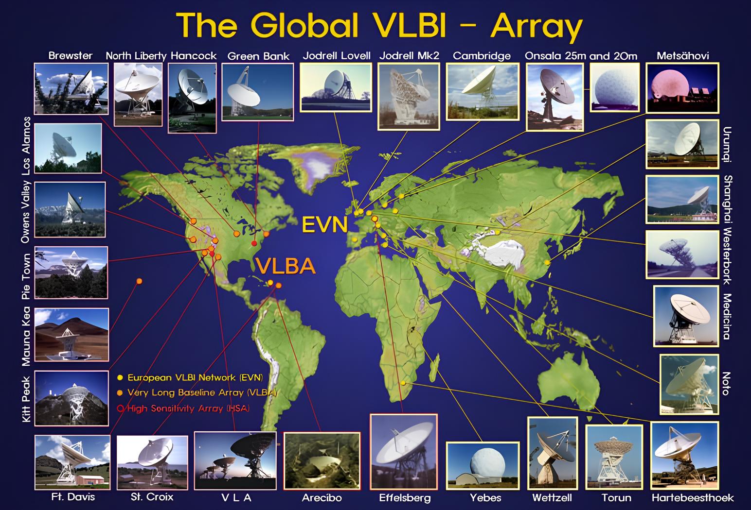
Fig.1: The distribution of VLBI sites around the world. (Credit: T. Krichbaum, MPIfR; https://geodesy.hartrao.ac.za/site/en/geodesy-equipment/radio-telescope-vlbi.html).
Why is VLBI important?
VLBI plays a fundamental role in both geodetic and astronomical applications due to its high-precision measurement capabilities. In the following, two main applications of VLBI in geodesy will be discussed.
Terrestrial reference frame and geodynamics
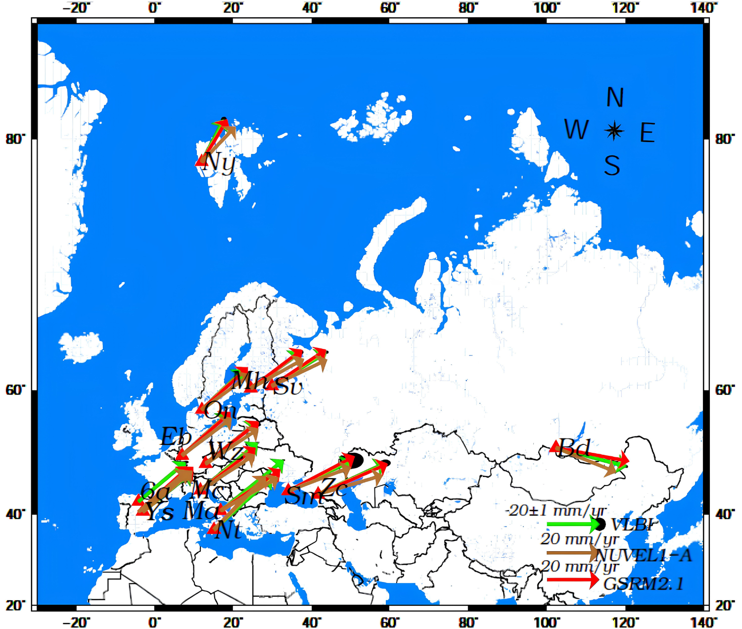
Fig. 2: Comparison of VLBI-derived velocities with modeled velocities from NUVEL-1A and GSRM2.1. Black, red, and blue arrows indicate GSRM2.1, geodetic VLBI, and NUVEL-1A velocities, respectively (Credit: [1]).
In [1], European VLBI observing sessions were analyzed to estimate station coordinates and velocities across Europe. As shown in Fig. 2, the motion of the Eurasian plate exhibits a northeastward trend, consistent with velocity fields derived from the GSRM2.1 and NUVEL-1A plate motion models.
Celestial reference frame
VLBI also plays a unique role in realizing the International Celestial Reference System (ICRS) through the International Celestial Reference Frame (ICRF), the fundamental radio reference frame based on observations of distant quasars. Therefore, unlike other space geodetic techniques such as Satellite Laser Ranging (SLR) and GNSS, VLBI provides a stable and highly precise inertial reference frame essential for Earth orientation parameter estimation and astrometric applications.
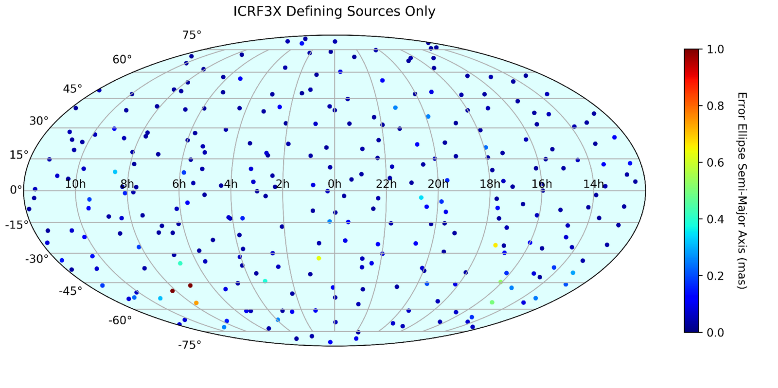
Fig. 3: Sky distribution of the 303 ICRF-3 defining sources (Credit: [2])
In summary, VLBI is a powerful technique that combines signals from widely separated telescopes to achieve exceptional precision, making it crucial for both Earth science and astronomical research.
How does VLBI work?
Imagine we use two radio telescopes separated by a very large distance that simultaneously observe the same quasar. Because the telescopes are located at different positions on Earth, the radio signal from the quasar reaches each station at slightly different times. Extremely precise atomic hydrogen maser clocks are used at each VLBI station to record the arrival time of the signal with high accuracy. The recorded signals are then compared using a processing method, which reveals the small time difference between their arrivals. This time delay is the fundamental observable in VLBI [3]. By knowing the speed of light ( m/s) and the relative geometry of the two telescopes, this measured time difference can be used to infer the projection of the baseline (b) between the stations; see Fig. 4. In this way, VLBI enables extremely precise determination of inter-station distances at the millimeter level [3,4].
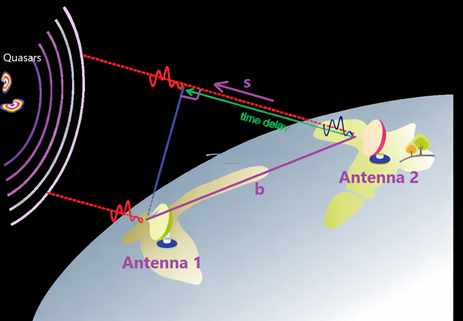
Fig. 4: Schematic of the fundamental VLBI principle (Credit: Mina Rahmani)
Due to the large distance between the two receivers, a time difference in the arrival of the wavefront emitted by a quasar at the two stations is expected. However, this calculated delay also includes contributions from other sources, including Earth orientation, the atmosphere, and instrument-related effects. Interested readers can find more details in [4]. Nevertheless, the majority of the measured delay is caused by the large separation between the two stations and is referred to as the geometric component.
The next generation of VLBI
To meet the strict performance targets established by the Global Geodetic Observing System (GGOS), namely global accuracies of 1 mm in station positions and 0.1 mm/year in station velocities, space-geodetic techniques such as VLBI are being advanced toward next-generation observing systems. These stringent requirements are driven by the need to detect and monitor extremely subtle but geophysically significant changes in the Earth system, including sea-level rise, tectonic plate deformation, glacial isostatic adjustment, and mass redistribution within the Earth’s oceans, atmosphere, and solid Earth.
GGOS serves as the global framework that integrates multiple space-geodetic techniques into a consistent and stable reference system, ensuring that observations from different methods are inter-comparable and physically consistent. Within this framework, VLBI plays a fundamental and unique role by providing the realization of the celestial reference frame and contributing to the definition of the scale of the terrestrial reference frame. In combination with complementary techniques such as GNSS and SLR, VLBI helps to maintain the long-term stability and accuracy of the global geodetic reference system.
To achieve these requirements, VLBI systems are evolving toward next-generation designs, called the VLBI Global Observing System (VGOS), characterized by increased automation, reduced infrastructure complexity, and faster slewing antennas, typically with diameters below 12 m. The next-generation VGOS-style systems use smaller, faster antennas because they can slew quickly and observe many sources across the sky, improving geometry and reducing systematic errors. However, this is not necessarily a contradiction of the point mentioned earlier that larger telescopes are better, as VLBI works on the concept of a virtual telescope whose size is given by the distance between the two involved telescopes.
Why does VLBI need modernization?
For VLBI, the original system was designed and constructed in the 1960s and 1970s. Consequently, aging antennas, increasing radio frequency interference (RFI), obsolete electronics, and high operating costs have created strong incentives for upgrading the VLBI system. These upgrades are essential to achieve the required levels of accuracy, reliability, and timeliness, including reducing the time interval between conducting observations and delivering initial geodetic results to less than 24 hours [5].
Final thoughts
VLBI shows how observations of distant quasars can help us understand our own planet. By measuring tiny differences in the arrival times of radio waves, scientists can determine station positions with millimeter accuracy and monitor tectonic plate motion. As next-generation VLBI systems are developed, this technique remains vital for understanding Earth’s dynamics and maintaining the global reference frame used for navigation, mapping, and space science.
References
- [1] Rahmani, M., Nafisi, V., Böhm, S., & Asgari, J. (2022). Evaluation of the GSRM2.1 and the NUVEL1-A values in Europe using SLR and VLBI-based geodetic velocity fields. Survey Review, 54(385), 349–https://doi.org/10.1080/00396265.2021.1943633
- [2] de Witt, A., Charlot, P., Gordon, D., & Jacobs, C. S. (2022). Overview and status of the international celestial reference frame as realized by VLBI. Universe, 8(7), 374; https://doi.org/10.3390/universe8070374
- [3] Takahashi, F. (ed) (2000). Very long baseline interferometer. Ohmsha, Tokyo. ISBN 978-1-58603-076-6
- [4] Sovers, O. J., Fanselow, J. L., & Jacobs, C. S. (1998). Astrometry and geodesy with radio interferometry: Experiments, models, results. Reviews of Modern Physics, 70(4), 1393. https://doi.org/10.1103/RevModPhys.70.1393
- [5] Petrachenko, W. T., Niell, A. E., Corey, B. E., Behrend, D., Schuh, H., & Wresnik, J. (2011). VLBI2010: next generation VLBI system for geodesy and astrometry. In Geodesy for Planet Earth: Proceedings of the 2009 IAG Symposium, Buenos Aires, Argentina, 31 August 31-4 September 2009 (pp. 999-1005). Berlin, Heidelberg: Springer Berlin Heidelberg. https://doi.org/10.1007/978-3-642-20338-1_125
Further reading
For those interested in learning more about VLBI, the following resources provide a good starting point:

https://plus.nasa.gov/video/using-quasars-to-measure-the-earth-a-brief-history-of-vlbi/
https://ivscc.gsfc.nasa.gov/
https://youtu.be/XcSZjT3oDSY?si=LyekXES5JSt_w755
– Edited by: Radoslaw Zajdel