During winter, mountains gain mass because of snow covering the peaks. In spring, the snow melts and flows downstream until it reaches the ocean or evaporates into the atmosphere to reach back on the surface as rain or snow. The global water cycle is very complex and essential for life on our planet. Did you know we can measure how the water is distributed by measuring its mass from space?
How can satellite gravimetry collect all that information?
Already since 2002, the twin satellites of the GRACE mission and its follow-on (GRACE-FO) have been measuring mass changes in the form of time-varying gravity field models. The GRACE satellites measured the distance between them with a micrometer precision. Measuring these tiny changes allows scientists to detect changes in Earth’s gravity. Of course not all mass changes are hydrological processes caused by water mass distribution over land. These observations also capture changes in the solid Earth, ice sheets, glaciers, the atmosphere and the oceans. Atmospheric effects and signals from the solid earth, like glacial isostatic adjustment (curious about this? Checkout our GIA-post!), are usually removed by models, leaving signals that can be primarily interpreted as mass redistribution associated with the movement of water within the Earth system.
What changed from GRACE to GRACE Follow-On satellites?
Almost one year after the end of the GRACE, the GRACE-FO was launched in 2018 with the same configuration but with a laser ranging interferometer that measures the inter-satellite distance far more accurately with nanometer precision. Gravity field measurements are more complicated than measuring the distance between the two chasing satellites. Additionally, their exact coordinates and orientation in space need to be known and all accelerations that are not caused by mass changes on Earth have to be compensated. To measure these accelerations caused by, e.g., atmospheric drag, each GRACE satellite has an accelerometer on board at the center of mass. Shortly after launch of GRACE-FO, the second satellite’s accelerometer unfortunately developed bias jumps that made it unusable for correcting non-gravitational forces. Luckily, this issue was resolved by “transplanting” accelerometer data from the first satellite to the second satellite.
Measuring water distribution over continents is essential for understanding our climate
One of the most important quantities derived from satellite gravimetry is terrestrial water storage (TWS). TWS represents all changes in continental water, including soil moisture, groundwater, surface water, snow, ice, and canopy water (see figure 1). In 2021, TWS was accepted as one of the official Essential Climate Variables. These variables are chosen as they describe key phenomena of the Earth’s climate system. Under climate change, the global water cycle intensifies and the water processes, such as evaporation, precipitation, and runoff, become faster. With every degree Celsius rise in global temperature, the air can store about 7% more moisture, and the increased evaporation intensifies rainfall events. In climate-vulnerable regions, these processes lead to more floods and droughts with severe effects on water supply, food security, and ecosystems. Estimates of TWS change help improve climate and hydrological models and make it easier to assess flood and drought events across large spatial scales (typically several hundred kilometers due to the coarse spatial resolution of GRACE and GRACE-FO).
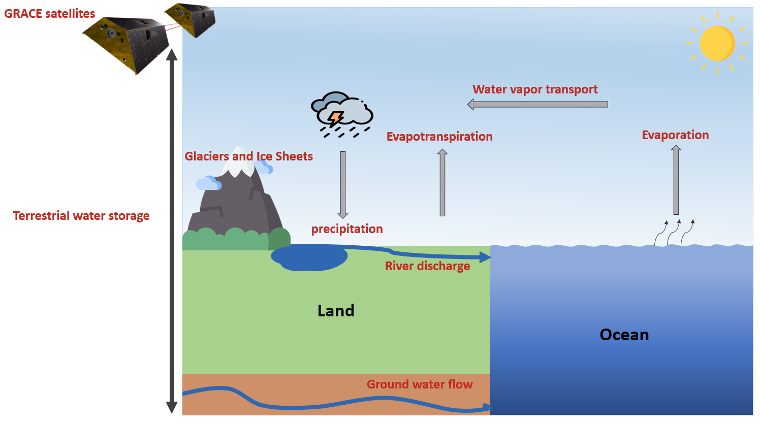
Figure 1: Terrestrial water storage and the water cycle. Water moves between land, ocean, and atmosphere through water fluxes. (credit: Kiana Karimi)
GRACE and the quantification of water storage change
A key parameter to understand of the water cycle at local and global scales is the total change in water storage over time as it constrains the processes of water entering (precipitation) and leaving a watershed (evapotranspiration and river runoff):
TWS rate = precipitation – evapotranspiration – runoff
Understanding how these water processes affect TWS in a watershed is important for future climate forecasting and water resources management because climate change can disrupt their balance. A decrease in TWS during a prolonged drought can be due to the lack of precipitation, higher evapotranspiration, or groundwater depletion. Also, flood events from extreme rainfall can be seen in increased TWS and runoff. Before GRACE, hydrologic models and ground-based observations often depended on assumptions or spatially incomplete data. Because of GRACE observations we can study water availability and long-term storage trends even in regions where ground observations are scarce.
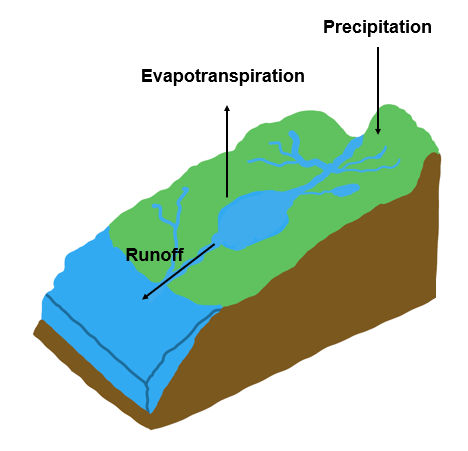
Figure 2: Water balance in a watershed. (credit: Kiana Karimi)
But there is more in GRACE data than the mass distribution of freshwater
Satellite gravimetry also helps in studying ocean mass change and sea level rise. Rising global temperatures increase the volume and mass of water in the oceans through ocean warming and melting of land-based ice, such as glaciers and ice sheets. GRACE and GRACE-FO measure mass change from ice melting and accumulation, especially in polar regions, which reveals how these processes add more water to the oceans. Combining GRACE observations with satellite altimetry data (curious? have a look at our Bits & Bites post on altimetry) enables separating sea level changes driven by ocean warming from those driven by freshwater entering the ocean. This helps us understand how different processes contribute to global sea level rise as an essential component of the water balance between land, ocean, and atmosphere.
The future of satellite gravimetry is MAGIC: The MAGIC mission
But this is not all! Because of the importance of gravity field measurements, they have to be continued in the future. The MAGIC mission is planned to be launched to continue the GRACE record. Gravity monitoring capabilities will improve significantly because MAGIC is planned as four satellites, operating in two pairs. The first pair is called GRACE-C with a near-polar orbit and the same accelerometer on GRACE-FO. The second pair is called the NGGM with an orbit inclination of around 70° and the next-generation accelerometer.
Together, the two satellite pairs will study water balance in smaller watersheds and detect droughts and floods with higher temporal resolution. MAGIC will help us to better see how climate change is reshaping water storage all across our planet.
– Edited by Marius Schlaak