The Gravity Recovery and Climate Experiment (GRACE) satellite mission (2002-2017) consisted of two satellites at ~500 km altitude separated by 200 km, following each other in the same orbit. The distance between the two GRACE satellites changes because of the gravitational pull of the masses beneath the satellites. As such, mass changes at or near the Earth’s surface caused variations in the distance between the two satellites over time. Following this basic concept, measuring inter-satellite distance by an ultra-precise microwave-based sensor with µm accuracy enabled the GRACE satellites to track the movement of terrestrial water storage (TWS) on land. This accuracy is equivalent to measuring the distance between Luxembourg and Brussels as precisely as 1/10 of the thickness of a human hair. The TWS consists of soil moisture, groundwater storage, snow water equivalent, and surface water (e.g., lake or river). GRACE provided monthly TWS changes with a spatial resolution of ~300 km.
The GRACE TWS changes have a coarse spatial resolution, which restricts the study of small-scale hydrological processes. This limits water management and hazard prediction efforts. However, their observations at large spatial scales (i.e., >300 km) are considered very accurate and reliably reflect natural and human-driven hydrological processes. TWS changes at smaller spatial scales (<300 km) can be predicted from hydrological models with a certain accuracy. Model data are often inconsistent with large-scale TWS observations from GRACE. Therefore, GRACE and models provide TWS maps with varying reliability and distinct characteristics at different spatial scales. It is desirable to combine the complementary features from these two TWS datasets and produce a fused dataset containing advantages from both datasets. Previous studies used machine learning and statistical approaches to combine the TWS changes from GRACE and hydrological models in the spatial domain.
We developed a spectral approach based on wavelet transform to combine the long-wavelength GRACE TWS changes with high-resolution TWS information from hydrological models. A wavelet is a mathematical function that decomposes data into different scale components. We used the wavelet approach to break down the TWS maps into their building blocks at different spatial scales and examined the signal characteristics of GRACE and model TWS changes at various spatial scales. We then combined the distinct spatial components of TWS maps such that the final fused or combined dataset preserves the complementary spectral information from both input datasets. In other words, the combined dataset possesses detailed TWS features from the model at spatial scales smaller than 300 km, while it also preserves accurate TWS information from GRACE at larger spatial scales. In this approach, the fusion is carried out at the wavelet coefficients level, and then the fused dataset is obtained using the inverse wavelet transform. The wavelet fusion approach is inspired by computer vision, where image fusion aims to integrate complementary information from multi-sensor data.
To demonstrate the usefulness of this approach, we combined maps of GRACE TWS changes from Jet Propulsion Laboratory (JPL) mascon solution that has an effective spatial resolution of 300 km with modelled TWS changes from the GLDAS Noah model at a spatial resolution of 50 km over the contiguous United States from January 2003 to December 2015. The below figure shows the results of the TWS combination using the wavelet approach for three example months. We see that the combined or fused TWS changes maps include large-scale features similar to GRACE, while also showing detailed features from the GLDAS Noah model. Finally, we provide a comprehensive validation of the fused TWS changes using internal measures as well as independent observations to check for the accuracy and consistency of the data set.
TWS is an important parameter to monitor the dynamic changes in Earth’s climate and water cycle. Nowadays, an increasing number of TWS datasets with diverse spatial and spectral resolutions are becoming accessible from various sources, including GRACE and GRACE Follow-On satellites, global hydrological models, land surface models, and the inversion of GNSS deformation measurements. The wavelet approach offers a flexible yet powerful tool to generate an enhanced TWS dataset that combines the complementary attributes from multiple datasets. The creation of more reliable, high-resolution TWS datasets, merging such complementary information, can be used to inform water management strategies.
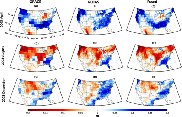
Figure: GRACE, GLDAS Noah and fused TWSC data in April, August and December 2003. GRACE monthly data is from JPL mascon solutions. Fused TWSC is obtained from a combination of GRACE and GLDAS monthly data using the wavelet multiresolution analysis.
Ghobadi-Far, K., Werth, S., & Shirzaei, M. (2023). A shrinkage-free approach for fusing GRACE-based total water storage changes with models using wavelet multiresolution analysis. Journal of Hydrology, 626, 130217. https://doi.org/10.1016/j.jhydrol.2023.130217.