Today, we are going to talk a little bit about dual-use, particularly in the context of geodesy. If you’re unfamiliar with the term, dual-use refers to the application of knowledge, information, data, products, or technology in ways that may deviate from their original scientific intent, often leading to ethical challenges. These challenges arise from the lack of control over who uses the data and for what purpose.
In geodesy, two key areas come to mind: Global Navigation Satellite System (GNSS) and gravity data. While GNSS technology has potential dual-use implications, such as open-source algorithms being repurposed for military applications, our focus today is on gravity data.
Gravity data collected from satellite missions has become an invaluable tool for understanding geophysical processes on Earth. These models provide insights into mass shifts due to ice melt, sea level rise, glacier melts, groundwater, and solid Earth activities. Complementing these satellite missions, local and regional gravity campaigns are often conducted on the ground/airborne/shipborne to increase the spatiotemporal resolution of the satellite gravimetry, crucial for detailed studies, such as:
- detecting short-term and small-scale mass changes,
- monitoring volcanic and low-frequency seismic activity,
- understanding the effects of irrigation and water depletion,
- identifying geothermal reservoirs, and
- exploring natural resources like oil, gas, and minerals.
Thus, the dual-use nature of this data—serving both climate and geophysical studies and resource exploration—creates ethical challenges related to responsibility and data ethics.
Unintended Use in Resource Exploration
Gravity data (satellite and all the other) and the technologies developed for gravity field modelling, such as gravity gradiometers, are meant for understanding geophysical processes. They also reveal significant details about subsurface structures. Sedimentary basins serve as an intricate archive; they record all sorts of dynamic processes, deformation of the lithosphere and its interaction with the deep mantle and surface processes. This means that they formed over hundreds of millions of years by the combination of these actions, and they can be rich in organic compounds i.e. hydrocarbons (fossil fuels). Fossil fuel-containing sediments, such as porous sandstones or limestones saturated with oil or gas, tend to have lower densities compared to non-organic rocks like compacted clay (unconventional oil and gas – shale gas – are exceptions)1. These density variations cause subtle changes in the local gravitational field, which can be detected and analyzed using gravity data from both satellite and terrestrial gravimetry. Large-scale/regional data can identify potential oil and gas deposits, providing cost-effective alternatives to ground surveys. However, the exploration of fossil fuels facilitates their extraction and use, which needs to be cut down to decrease the emission level by almost half by 20302. This forms the basis of the dual use, with some examples including Gravity Recovery and Climate Experiment (GRACE)3 and Gravity Field and Steady-State Ocean Circulation Explorer (GOCE)4,5 data and technologies.
This dual-use nature extends to the detection of groundwater resources. Trends in total water storage can be detected using satellite gravity data6,7,8,9,10,11. This is particularly important for regions facing drought, where managing water resources is critical for sustaining life and agriculture8,10,11,12,13. While this is the case, the same data can be exploited by corporations to over-extract these resources, causing socio-economic and environmental issues in local communities, mostly affecting indigenous communities (extraction of lithium, essential for batteries, requires significant amounts of water – example from Chile, Atacama Desert, Bolivia; excessive water extraction in Mexico, China, California, France; excessive irrigation – example from America). These examples highlight the relevance of gravity data in managing and monitoring groundwater resources. Companies involved in water-intensive industries could potentially use gravity data to identify and exploit groundwater resources more efficiently, sometimes at the expense of local communities and ecosystems. Understanding these dynamics is crucial for developing ethical guidelines around the use of such data.
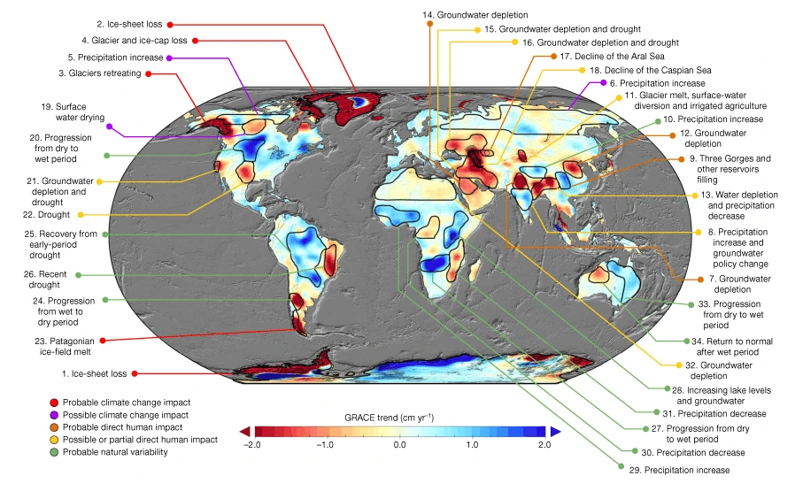
Trends in total water storage observed by GRACE. Taken from Rodell, Matthew, et al. “Emerging trends in global freshwater availability.” Nature 557.7707 (2018): 651-659.
So, what can we do?
To wrap up the discussion, we can draw from examples in various fields where policies have been established to address dual-use challenges. For instance, in the life sciences, the U.S. Government Policy for Oversight of Life Sciences Dual Use Research of Concern (DURC) is designed to prevent misuse of research that could pose significant threats to public health, safety, and national security. Similar frameworks exist in biotechnology to prevent the development of biological weapons and in cybersecurity, where ethical guidelines aim to prevent the exploitation of software vulnerabilities for malicious purposes; European Union (EU) has specific regulations for these.
Considering the urgency of the climate crisis, it may be time to develop similar policies and guidelines for the use of gravity data, ensuring it is used responsibly and ethically in both climate research and resource exploration. IPCC reports do not specifically focus on this topic. Still, they discuss the broader implications of technological innovation, including potential unintended consequences that could arise when technology developed for climate mitigation or other environmental purposes is exploited for uses that might not align with sustainability goals. IPCC also has a task group on Data (TG-Data) to work on ensuring the responsible use and availability of climate-related data.
The versatile nature of gravity data, while initially designed for climate studies, inadvertently supports resource exploration. Navigating this dual-use requires transparent acknowledgement of funding sources, vigilance against greenwashing, and responsible handling of data access challenges. A balanced approach – fostering open dialogue, engaging communities, and establishing ethical protocols – is essential to ensure gravity data becomes a force for positive change while averting unintended consequences.
Edited by Marius Schlaak and Rebekka Steffen
References

*news articles are attached as links and not listed here

[1] McCulloh, T. H. (1967). Mass properties of sedimentary rocks and gravimetric effects of petroleum and natural-gas reservoirs (No. 528-A). US Govt. Print. Off.,.
[2] IPCC, 2023: Summary for Policymakers. In: Climate Change 2023: Synthesis Report. Contribution of Working Groups I, II and III to the Sixth Assessment Report of the Intergovernmental Panel on Climate Change [Core Writing Team, H. Lee and J. Romero (eds.)]. IPCC, Geneva, Switzerland, pp. 1-34, doi: 10.59327/IPCC/AR6-9789291691647.001
[3] Newaz, S., Tahmid, M. T., Al-Aboody, N., & Islam, A. A. A. (2023). A ubiquitous method for predicting underground petroleum deposits based on satellite data. Scientific Reports, 13(1), 6638.
[4] Finding fossil fuels from the Air. ESA website. (n.d.). https://www.esa.int/Enabling_Support/Preparing_for_the_Future/Space_for_Earth/Energy/Finding_fossil_fuels_from_the_air
[5] Searching for underground energy sources from space. ESA website. (2015). https://www.esa.int/Applications/Observing_the_Earth/FutureEO/GOCE/Searching_for_underground_energy_sources_from_space
[6] Rodell, M., Famiglietti, J. S., Wiese, D. N., Reager, J. T., Beaudoing, H. K., Landerer, F. W., & Lo, M. H. (2018). Emerging trends in global freshwater availability. Nature, 557(7707), 651-659.
[7] Rodell, M., Velicogna, I., & Famiglietti, J. S. (2009). Satellite-based estimates of groundwater depletion in India. Nature, 460(7258), 999-1002.
[8] Famiglietti, J. S., Lo, M., Ho, S. L., Bethune, J., Anderson, K. J., Syed, T. H., ... & Rodell, M. (2011). Satellites measure recent rates of groundwater depletion in California's Central Valley. Geophysical Research Letters, 38(3).
[9] Hu, Z., Zhou, Q., Chen, X., Chen, D., Li, J., Guo, M., ... & Duan, Z. (2019). Groundwater depletion estimated from GRACE: A challenge of sustainable development in an arid region of Central Asia. Remote Sensing, 11(16), 1908.
[10] Ouma, Y. O., Aballa, D. O., Marinda, D. O., Tateishi, R., & Hahn, M. (2015). Use of GRACE time-variable data and GLDAS-LSM for estimating groundwater storage variability at small basin scales: a case study of the Nzoia River Basin. International Journal of Remote Sensing, 36(22), 5707-5736.
[11] Bonsor, H. C., Shamsudduha, M., Marchant, B. P., Macdonald, A. M., & Taylor, R. G. (2018). Seasonal and decadal groundwater changes in African sedimentary aquifers estimated using GRACE products and LSMs. Remote Sensing, 10(6), 904.
[12] Herrera, C., Gamboa, C., Custodio, E., Jordan, T., Godfrey, L., Jódar, J., ... & Sáez, A. (2018). Groundwater origin and recharge in the hyperarid Cordillera de la Costa, Atacama Desert, northern Chile. Science of the Total Environment, 624, 114-132.
[13] Bostic, D., Mendez-Barrientos, L., Pauloo, R., Dobbin, K., & MacClements, V. (2023). Thousands of domestic and public supply wells face failure despite groundwater sustainability reform in California’s Central Valley. Scientific Reports, 13(1), 14797.
Caroline Rogers
Good point, as so often is the case, what is initially very valuable geodesy research ends up
exploited by private equities aiming for profit with complete disregard for local communities
or the health of the planet, I think data use should be strictly kept for non profit/ earth friendly
use but unfortunately this is not achievable in the society we live in. Well done for highlighting
this very worrying issues in a very clear and concise way.