
Viedma glacier (~1000 km2) is the second largest glacier of the Andes. [Credit: Pierre Pitte; Inventario Nacional de Glaciares de Argentina]
Extending for almost 8,000 km along the west of South America, the Andes are the longest continental mountain range in the world. They portray an impressive richness and diversity of cryospheric features, including:
- the most substantial extension of tropical glaciers on Earth,
- one of the highest densities of rock glaciers,
- the largest glacierized area in the Southern Hemisphere outside Antarctica,
- the most significant extension of seasonal snow and mountain permafrost in this part of the globe.
Although crucial for ecosystems and communities, the Andean cryosphere is being strongly affected by anthropogenic climate change. Adaptation measures need to incorporate the diversity of cultures and regions along the Andes to tackle future challenges.
In this blog post, you will find an introduction to the fascinating diversity of climatic regions and cryosphere features in the Andes.
DID YOU KNOW THAT THE ANDES…
- were formed by the subduction of oceanic plates under the South American continental plate approximately 140 million years ago?
- are the second-highest mountain range in the world, after the High Mountain of Asia?
- have an average altitude of 4,000 m, with many peaks higher than 6,000 m above sea level?
- host the highest mountain outside Asia, Mount Aconcagua in Argentina, at 6,960 m, and the highest volcano on Earth, Ojos del Salado on the border of Chile and Argentina, at 6,893 m?
Extending for almost 8,000 km along the west of South America, the Andes portray an impressive richness and diversity of cryospheric features, playing a critical hydrological, climatological, and socio-economic role for the Andean countries. Indeed, many varieties of glaciers can be seen along the Andes, from large tide-water and lake-water calving glaciers, passing through sizeable debris-covered valley glaciers, surging glaciers, and cold-based mountain glaciers.
But how is all this variation possible in one place? The main cause is the Andes’ extensive latitudinal range. But besides the decrease in incoming solar radiation and the cooling from north to south, the Andes also act as a barrier for the main atmospheric circulation patterns, modulating the spatial and temporal distribution of precipitation across western South America and creating specific hydro-climatic regimes at different latitudes.
Cryosphere features (snow, glaciers, and even permafrost) located in contrasting climates can respond with varying magnitudes to identical climatic perturbations. This implies that understanding the differences between regions, in terms of climate conditions and the process behind them is crucial to assess the response of the cryosphere to climate change. To this end, let me introduce you, from north to south, the main hydroclimatic regions of the Andes, highlighting the different expressions of the cryosphere in each region.
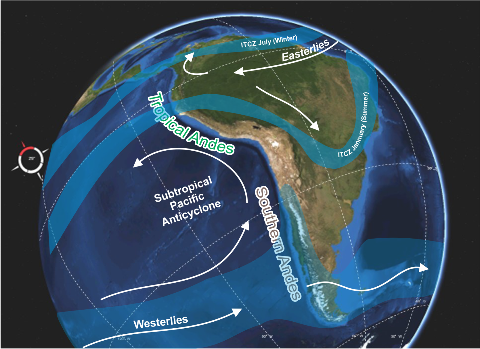
The Andes along the west of South America acts like a barrier to the main atmospheric circulation patterns. [Credit: Lucas Ruiz; background image from Visible Earth]
THE TROPICAL ANDES
In the tropical Andes, which extend from their northernmost point southwards until the Bolivian border, glaciers are shrinking fast. Local glacier retreat over the last three decades is unprecedented since the maximum extension of the Little Ice Age. Even under low emission scenarios, it is expected that these glaciers will continue shrinking at a faster rate. Due to high radiation levels and warm air temperatures, tropical glaciers have year-round ablation conditions close to the glacier snout.
In this region, the moisture has an Atlantic origin and is transported to the mountains by the easterly circulation (see the figure above). The seasonality of precipitation is controlled by the yearly travel of the Inter-Tropical Convergence Zone (ITCZ).

Volcan Nevado del Huila glaciers in the inner Tropical Andes of Colombia [Credit: Wikipedia Commons]
THE INNER TROPICAL ANDES
In the inner tropics (Venezuela, Colombia, and Ecuador), there are two wetter seasons; one in autumn (April to May) when the ITCZ moves northward and one in spring (October to November) during the southward passage of the ITCZ. In this region, glaciers are located at high, isolated peaks, surrounded by the Páramo ecosystem, where evidence of patterned ground and other periglacial environments features have been observed. These small glaciers are sensitive to year-to-year variations in air temperature and the type of precipitation (rain or snow).
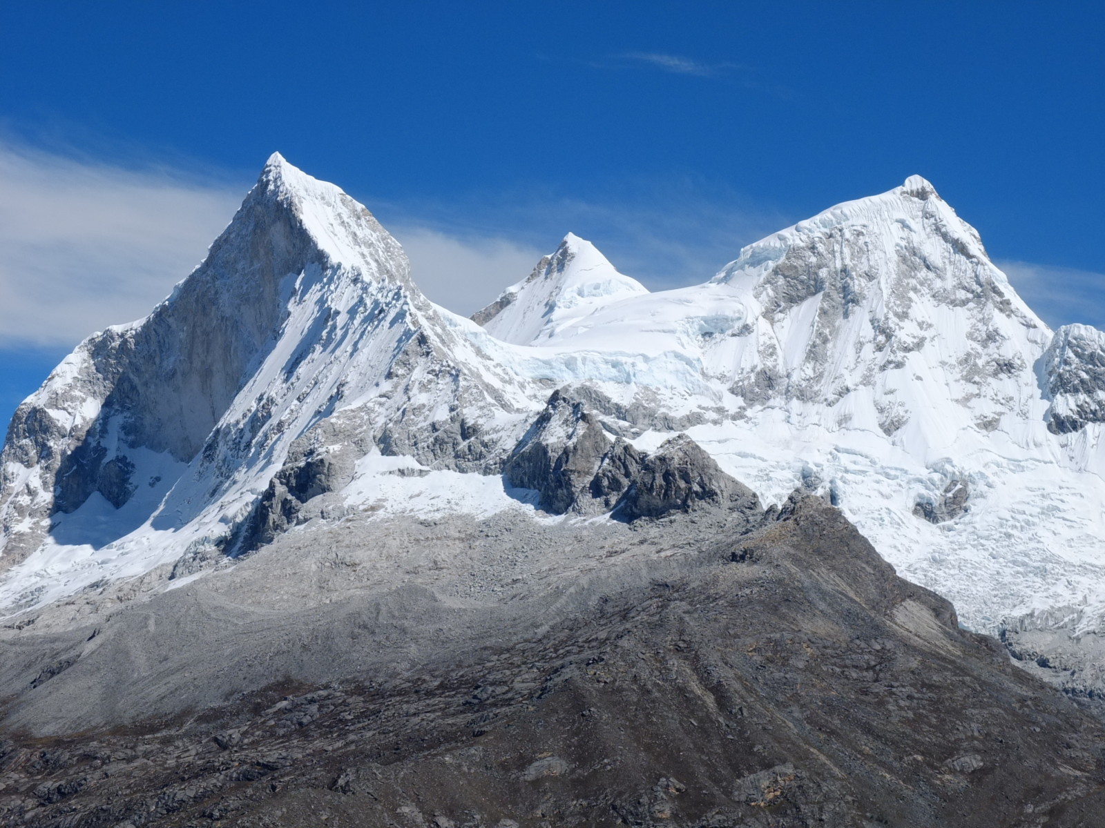
Huandoy peak (6395m), Cordillera Blanca, Ancash region, in the outer Tropical Andes of Peru. [Credit: Marguerite, Flicker]
THE OUTER TROPICAL ANDES
Further south, in the outer tropical Andes (Bolivia and Peru), there is only one wet season during the summer months (November to April, when the ITCZ reaches these latitudes), meaning both high ablation and accumulation happen at the same time. Here, the annual surface mass balance of glaciers depends mostly on the beginning of the wet season (summer), which interrupts the period of high melt caused by solar radiation. Any delay in the onset of the wet season and the concurrent accumulation of snow creates a very negative surface mass balance. In this region, high solar radiation throughout the year means that snow falling away from the glacier lasts no more than a few days, strengthening the importance of glaciers to maintain water availability in the dry periods of the year. At the southern margin of this region, in the Bolivian Andes, rock glaciers and mountain permafrost conditions have been recognized above 4700 m.
THE SOUTHERN ANDES
Best known as the most extensive glacierized mountain range of the Southern Hemisphere, the Southern Andes (the Andes of Argentina and Chile) are one of the most significant contributors to sea-level change. According to contrasting hydro-climatic conditions, they can be divided into two subregions: the Dry Andes (17.5°S to 35°S) and the Wet Andes (35°S to 55°S).

Corona del Inca Pillo, in the Desert Andes of Argentina [Credit: Juan Pablo Scarpa; Inventario Nacional de Glaciares de Argentina]
THE DRY ANDES
In the northern part of the Dry Andes (knows as the Desert Andes; 17°S to 31°S), precipitation still has a predominantly Atlantic origin. It is driven primarily by the easterlies associated with the South American monsoon system and occurs during the summer months (November to March). Here (as the name suggests!), precipitation amounts are comparatively much lower than those observed further north in the tropical Andes, with a minimal number and extent of glaciers, despite the high elevation.
Further south, in the Central Andes of Argentina and Chile (31°S to 35°S), most of the precipitation has a predominantly Pacific origin. The location of the subtropical Pacific anticyclone plays a significant role in the intensity of the westerlies and precipitation seasonality. In winter, the displacement of this high-pressure area to the Equator allows the westerly storm tracks to move northward which results in a peak in precipitation. This, in combination with the high elevation of the Andes, produces a large concentration of glaciers and seasonal snow-covered areas, contrasting with further north.
Glaciers in the Dry Andes constitute a crucial water reserve and play a significant hydrological role during extended dry periods or at the end of the warm season (when most of the seasonal snow has disappeared from the mountains). In years of normal or high snowfall, seasonal snow provides the most significant proportion of surface run-off in this region. Currently, there is a lack of snow due to the “megadrought” that started in 2010. This has put additional pressure on the limited water resources and on the glaciers of this region. Along this region, glaciers are sensitive to the inter-annual variability in seasonal snow accumulation.
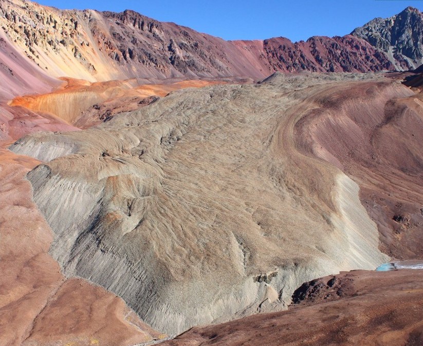
The stunning Calingasta glacier is a complex unit that start as clean-ice at high elevation and ends as rock glacier [Credit: Mariano Castro; Inventario Nacional de Glaciares de Argentina]
Like other high mountain areas, mountain permafrost conditions are widespread in the Dry Andes. Notably, along the central Andes, there is an impressive concentration of rock glaciers, including many complex units that begin as clean-ice glaciers at high elevations, gradually turn into debris-covered glaciers further down, and finally, end as rock glaciers at the lowest sectors.
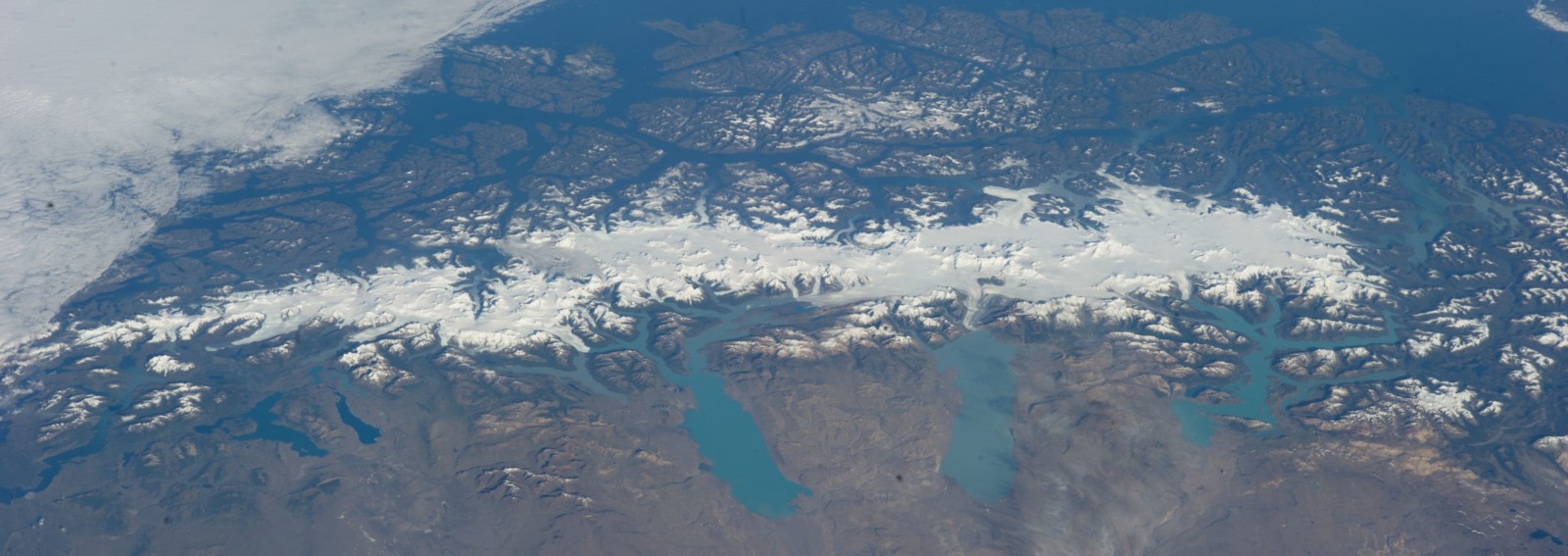
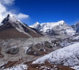
The Southern Patagonian Icefield (~12000 km2), the more substantial glacier extension in the Southern Hemisphere outside Antarctica, seeing from the International Space Station in February of 2014 [Credit: NASA].
THE WET SOUTHERN ANDES
Further south, the so-called Wet Andes (35°S to 55°S) are exposed to the westerlies throughout the year. Precipitation is thus more uniformly distribute amongst the different seasons. In the Northern Patagonian Andes (between 35°S to 45°S) glaciers are located only at the higher mountains and volcanos due to its relatively lower elevation. In the Southern Patagonian Andes (between 45°S to 55°S), the higher and more frequent snow accumulation supports extensive glaciers and icefields. The Wet Andes are also characterized by a sharp precipitation gradient, with clear contrasts between the wetter western slopes and the much drier conditions to the east. This favours the development of permafrost condition and the presence of rock glaciers at the Wet Andes of Argentina.
Increasing air temperature and decreasing precipitation have been recognized as the trigger for glacier shrinkage in this region. Still, the calving flux of the massive outlet glaciers of the icefields is defining the glacier mass loss of the Wet Andes.
The hydrological significance of glaciers in the Wet Andes is comparatively lower than further north. Indeed, higher precipitation amounts make most rivers dependent on rainfall and snowmelt patterns instead of glaciers. However, shrinkage of the largest glaciers in the South Patagonian Andes have a noticeable increase in the run-off of some of the most important rivers in the region.
TO SUM UP
Although crucial for ecosystems and communities, the Andean cryosphere is being strongly affected by the anthropogenic climate change. Adaptation measures need to incorporate both the scientific and the traditional knowledge of the region to tackle the future challenges that the changing climatic conditions will pose. The sustained work of monitoring programs in the Andean countries in combination with the analyses made from remote sensors and modelling techniques, gives a consistent framework to ground climate policies and to highlight our future challenges.
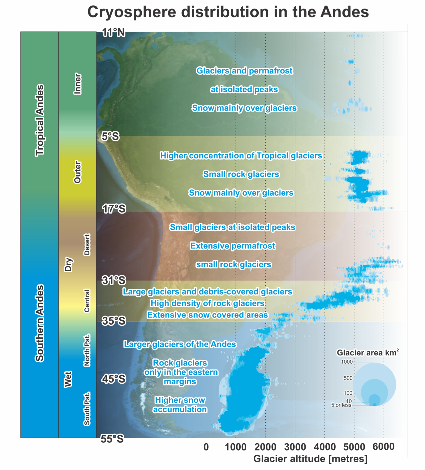
Summary of the different regions along the Andes and its main cryosphere features[Credit: Lucas Ruiz, background image from Visible Earth].
Further Reading
- Antarcticglaciers.org has an updated and comprehensive introduction to the Patagonian icefields.
- Inventario Nacional de Glaciares de Argentina, the official site of the glacier inventory of Argentina (in Spanish).
- Laboratorio de Glaciologia de Chile, information, and data of the glaciers of Chile (in Spanish).
- Glacioclim Andes, an international project monitoring glaciers in the Tropical Andes.
Edited by Emma Pearce
Lucas Ruiz is a glaciologist at the IANIGLA (Instituto Argentino de Nivología Glaciología y Ciencias Ambientales), Argentina. He Investigates the mass balance and glacier dynamics of Andean glaciers to elucidate how climate change is affecting them, and, in this way, help to understand the impact that this would have on the water resources of the different regions of the Andes. He tweets as @ARGlaciares. Contact Email: lruiz@mendoza-conicet.gob.ar
.jpg)
Jorge Luis Ceballos
Super!!! Cryo-diverse!! What word, wow!!
Thanks a lot.