Invited guest from the EGU 2025 Outstanding Student and PhD candidate Presentation (OSPP) Award
Wind is not easily visible. On historical time scales, its directions and velocities have been measured and recorded by instruments. To some degree, these parameters can also be simulated by climate models.
But how about winds in the more distant past? And why would we want to know about them?
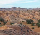
In many places, wind has been a key agent in shaping the development of landscapes. This is especially common in cold and arid places due to the lack of moisture and vegetation, which makes it easy for winds to pick up sediment grains and transport them across varying distances. For example, in the country where I live, Sweden, a barren landscape was exposed during deglaciation. Among other factors, strong winds from the retreating ice margin redistributed sediments which resulted in the formation of sand dunes. Their orientation in the landscape is largely determined by the direction from which the wind was blowing. This example shows that some landforms which are formed through deposition of sediments by wind (such as dunes) or shaped by abrasion through wind (yardangs, ventifacts) can record wind directions of the past.
However, how can we reconstruct past wind directions if such landforms are absent?
We can search for answers in the sedimentary deposits that are created by wind. Wind-transported sediments consist of individual rock particles of different shapes, sizes, and mineralogies. During aeolian transport, elongated particles tend to orientate themselves along the direction of the wind and to retain this position when they are being deposited. Loess is a sediment that consists of fine wind-transported, silt-sized mineral particles that are finer than sand. It is known for not having any visible sedimentary structures that can directly provide information about wind directions. However, if we find a way to measure the orientation of individual grains, then we can infer wind directions from the sedimentary deposit.
Overall, it is very tricky to assess the orientation of very small grains inside a sediment sample in a precise way. One method that allows us to indirectly do so is anisotropy of magnetic susceptibility. The idea behind the technique is that we take a small, intact block of sediment in the field and measure its geographical orientation. Then, we place it into an instrument that exposes the sample to a magnetic field. A natural sediment sample, such as loess, usually contains a small fraction of particles that are magnetic and react to this external magnetic field. If we rotate the sample inside the magnetic field, we can measure how the response of the sample changes with the changing position inside the magnetic field. Based on this information, we can determine the orientation of the magnetic grains, which in turn represents the wind direction in the past.
In our recent paper, we measured the orientation of many orientated sediment samples that were taken from three loess outcrops in Tajikistan, Central Asia. The oldest of these samples is about 1.2 million years old and our record provides snapshots over this entire period. We investigated wind directions on such a long time scale because we know that global climate changed drastically over this time: more intensive and longer glacial periods occurred after roughly 700 000 years ago, and interglacials became warmer around 430 000 years ago. It appears plausible that these changes affected regional circulation patterns and hence, the directionality of the winds that transported the dust that the loess deposits consist of. Also, we know that early humans lived in today’s Tajikistan episodically from around 930 000 years ago, but we do not know how regional climate affected their livelihoods. Therefore, we assessed whether any indication for a change in wind direction could be seen in the orientation of magnetic particles in the loess sediments of Tajikistan.
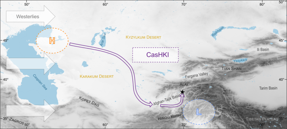
We found that the orientations of magnetic particles in the three investigated loess sites support surprisingly stable wind directions over the entire period of 1.2 million years. This constancy is best explained by a persistent dominance of the mid-latitude westerly winds. On a local scale, these winds were deflected by the regional topography, most prominently the mountain ranges Pamir, Hindu Kush, and Alai (Figure 1). Therefore, the wind directions that are seen in the sedimentary deposits are not strictly westerly, but south-west to southerly.
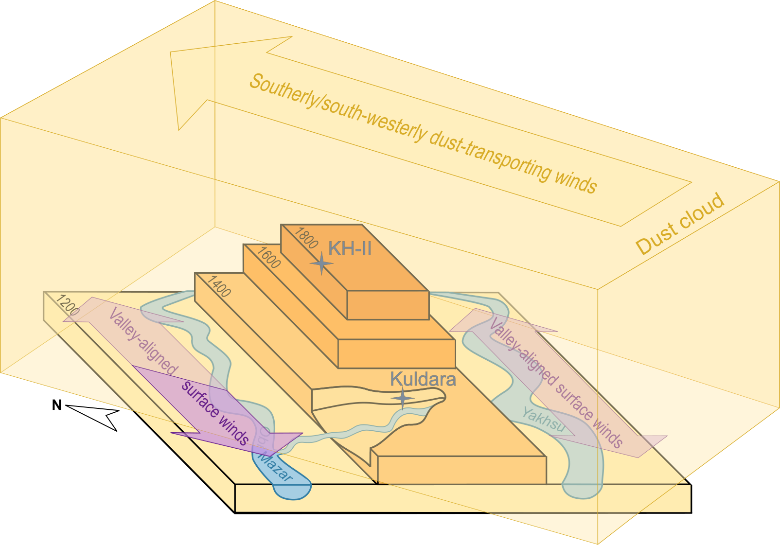
Figure 2: Conceptual visualisation of how topography affects preserved wind directions. Sites on topographic ridges (here: KH-II) can record the direction of region-wide dust transporting winds. Sites that are more confined, for example, close to the bottom of a valley (here: Kuldara) tend to record more local winds. Figure from Schneider et al. (2026).
We also found that geomorphology plays a large role for the preservation of a wind signal in the orientation of magnetic particles. Locations on topographic ridges are best for preserving the directions of dust-transporting winds that act over a wider area (Figure 2). By contrast, our data showed that locations in topographically confined areas, for example close to the bottom of a river valley, are more affected by surface winds that follow the local topography.
To read more about our research and which role the stability of wind directions could have played for the environments of ancient humans in Central Asia, you can access our article here.
This post has been edited by the editorial board
Ramona Schneider was awarded for the poster/PICO entitled: “Magnetic fabric of Tajik loess-palaeosols as a palaeowind and process indicator”. Click here to download the poster/PICO file.
References:

Bradák, B., Seto, Y., Chadima, M., Kovács, J., Tanos, P., Újvári, G., and Hyodo, M.: Magnetic fabric of loess and its significance in Pleistocene environment reconstructions, Earth-Science Reviews, 210, 103385, https://doi.org/10.1016/j.earscirev.2020.103385, 2020.

Kaskaoutis, D. G., Rashki, A., Houssos, E. E., Legrand, M., Francois, P., Bartzokas,A., Kambezidis, H. D., Dumka, U. C., Goto, D., and Takemura, T.: Assessment of changes in atmospheric dynamics and dust activity over southwest Asia using the Caspian Sea–Hindu Kush Index, International Journal of Climatology, 37, 1013–1034, https://doi.org/10.1002/joc.5053, 2017.

Schneider, R., Kulakova, E., Almqvist, B., Niezabitowska, D., Leeding, R., Kurbanov, R., and Stevens, T.: Stable dust-transporting winds in Central Asia over the last 1.2 million years, Quaternary Science Reviews, 376, 109799, https://doi.org/10.1016/j.quascirev.2026.109799, 2026.