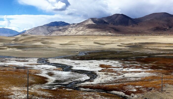
EGU Blogs

Highlights

CR
Cryospheric Sciences

Image of the Week – On thin [Arctic sea] ice

Image of the Week – On thin [Arctic sea] ice

Perhaps the most enduring and important signal of a warming climate has been that the minimum Arctic sea ice extent, occurring each year in September, has declined precipitously. Over the last 40 years, most of the Arctic sea ice has thus been transformed to first-year ice that freezes in the winter and melts in the summer.            Concern about sea ice extent and area is valid: since sea ice i ...[Read More]

GeoLog

EGU announces 2019 awards and medals

EGU announces 2019 awards and medals

From 14th to the 20th October a number of countries across the globe celebrate Earth Science Week, so it is a fitting time to celebrate the exceptional work of Earth, planetary and space scientist around the world. This week, the EGU announced the 45 recipients of next year’s Union Medals and Awards, Division Medals, and Division Outstanding Early Career Scientists Awards. The aim of the awards is ...[Read More]

GeoLog

Educators: apply now to take part in the 2019 GIFT workshop!

Educators: apply now to take part in the 2019 GIFT workshop!

The General Assembly is not only for researchers but for teachers and educators with an interest in the geosciences also. Every year the Geosciences Information For Teachers (GIFT) is organised by the EGU Committee on Education to bring first class science closer to primary and high school teachers. The topic of the 2019 edition of GIFT is ‘Plate tectonics and Earth’s structure – yesterday, today, ...[Read More]

GeoLog

Imaggeo on Mondays: Life between the arid mountains of Gansu, China

Imaggeo on Mondays: Life between the arid mountains of Gansu, China

Even within Earth’s more arid environments, you can find life! This featured photo was taken near the Lanzhou Zhongchuan Airport, about 50 km away from Lanzhou city, the capital of Gansu province in Western China. The area lies in a region between the Qinghai-Tibet Plateau and the Loess Plateau, with an elevation ranging from 1,500 m to 2,200 m. The landscape is dominated by a network of ridges an ...[Read More]

GD
Geodynamics

Oceans on Mars: the geodynamic record

Oceans on Mars: the geodynamic record

Apart from our own planet Earth, there are a lot of Peculiar Planets out there! In this series we take a look at a planetary body or system worthy of our geodynamic attention, and this week we are back to our own solar system, more precisely to our neighbour Mars. In this post, Robert Citron, PhD student at the University of California, Berkeley, writes about the links between oceans, shorelines, ...[Read More]

CR
Cryospheric Sciences

Image of the Week — Cryo Connect: connecting cryosphere scientists and information seekers

Image of the Week — Cryo Connect: connecting cryosphere scientists and information seekers

Communicating scientific findings toward non-experts is a vital part of cryosphere science. However, when it comes to climate change and its impact, the gap between scientific knowledge and human action has never been so evident (see for instance, the publication of the latest IPCC special report). Today, our image of the week features an interview with Cryo Connect, a new initiative for more effi ...[Read More]

GeoLog

Discover geology with Lego!

Discover geology with Lego!

Science communication is becoming a widely recognized skill for both established and budding geoscientists alike. Outreach activities are beneficial in many ways, as they not only showcase science to the general public, but also give scientists the chance to develop transferable skills. If you’re in the market for a creative geoscience activity, one that especially appeals to a younger audience, l ...[Read More]

GD
Geodynamics

It’s just coding … – Scientific software development in geodynamics

As big software packages become a commonplace in geodynamics, which skills should a geodynamicist aim at having in software development? Which techniques should be considered a minimum standard for our software? This week Rene Gassmöller, project scientist at UC Davis, Computational Infrastructure for Geodynamics, shares his insights on the best practices to make scientific software better, and ho ...[Read More]

SM
Seismology

Palu 2018 – Science and surprise behind the earthquake and tsunami

On September 28, 2018, a powerful 7.5-magnitude earthquake and an unexpected tsunami shook the Indonesian island of Sulawesi, leaving behind catastrophic results and open questions among geoscientists. How come this event is having such an impact on the scientific community?   What we know so far On Friday afternoon (at around 5pm Western Indonesian Time) the Minahassa Peninsula on Sulawesi i ...[Read More]