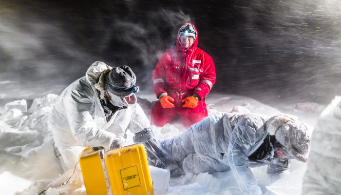
A new global S-wave model has recently been published in Geophysical Journal International. While this sounds exciting enough to tomographers and geodynamicists, this model has been constructed in a rather avant-garde way, too. It is one out of only two global tomographic models ever to be made based on the Earth’s background oscillations, that is long-periodic seismic noise also known as Earth’s ...[Read More]
If you didn't find what you was looking for try searching again.
WaterUnderground
Water Canada article on our research
Scott Jasechko and I wrote an article for Water Canada about our research on modern groundwater published last fall in Nature Geoscience. We tried desperately to use plain language… how did we do? See WaterCanadaWinter2016
GeoSphere
GeoPoll: Who do you think most deserves the title “Father of Geology?”
It’s been a while since the last geopoll/post. Too long. Life has been busy for me though. I am just concluding an extremely short post-doc at Health Canada’s Canadian Radiological Monitoring Network and am starting a new job at the Canadian Nuclear Safety Commission next week. Suffice to say blogging has sadly slipped a bit lower on my list than I’d like. Plus it’s hockey ...[Read More]
GeoLog
GeoTalk: Meet Zakaria Ghazoui, winner of the Communicate your Science Video Competition in 2015!
If you’ve not heard about our Communicate Your Science Video Competition before it gives early career scientists the chance to produce a video up-to-three-minutes long to share their research with the general public. The winning entry receives a free registration to the General Assembly the following year. In this GeoTalk interview, Laura Roberts talks to Zakaria Ghazoiu, a PhD student whose video ...[Read More]
Geology for Global Development
UNISDR Science and Technology Conference on the Implementation of the Sendai Framework for Disaster Risk Reduction 2015-2030
Over the next few days (27-29th January) we’ll be attending the UNISDR Science and Technology Conference on the Implementation of the Sendai Framework for Disaster Risk Reduction (SFDRR) 2015-2030. Agreed in March 2015, this framework aims to substantially ‘reduce disaster risk and losses in lives, livelihoods and health and in the economic, physical, social, cultural and environmental asset ...[Read More]
GeoLog
Imaggeo on Mondays: A hidden waterfall
It’s fascinating how a relatively small outcrop, carved out by rivers and ancient ice, can reveal much about the geological history of an area. Today’s Imaggeo on Mondays post is one such example. Antonio Girona, a researcher at the University of Zaragoza, gives us a whirlwind tour of the geological history of the rocks revealed by the Sorrosal Waterfall, in Spain. The visit to the Sorrosal Waterf ...[Read More]
GeoLog
Geosciences Column: Three hundred years probing the deep seas
The depths of the deep blue have fascinated explorers, scientists and humanity for centuries. And is it any wonder? 71% of the Earth’s surface is covered by oceans teaming with riches, from unique forms of life to precious metals.Even today, there are vast regions of the ocean floors that remain unexplored and of which we know very little about. Some might argue the oceans are the last unexplored ...[Read More]
Cryospheric Sciences
Image of Week: Blue Ice in East Antarctica
The blue ice areas of Antarctica are one of the most fascinating parts of the ice sheet. In these regions, snowfall is so low that the ice is laid bare by the wind and consequently sublimates. This exposes beautiful, blue ice surfaces, like an ocean frozen in time. This picture was taken at a site named “Windy Corner” by the Kottas Mountains, in the northernmost part of the Heimefrontf ...[Read More]
GeoLog
Imaggeo on Mondays: The retreating glaciers of the Svaneti Range, Georgia
Today’s Imaggeo on Mondays picture shows the central section of the Svaneti Range, located in the Svaneti Region – a historic province of northwestern Georgia. The range is the second biggest range formed by the modern glaciation on the southern slopes of the Georgian Caucasus Mountains. In today’s post, Levan Tielidze, a researcher at Ivane Javakhishvili Tbilisi State University, writes about the ...[Read More]
Cryospheric Sciences
Image of the Week — Greenland ice sheet and clouds
A new study combining satellite observations and model simulations shows that clouds increase meltwater runoff in Greenland by one-third compared to a cloud-free scenario. Precipitation effects not considered, clouds above the Greenland ice sheet reduce its Surface Mass Balance (SMB) [red in figure] compared to clear-sky conditions [blue in figure]. Because clouds trap the outgoing radiation from ...[Read More]