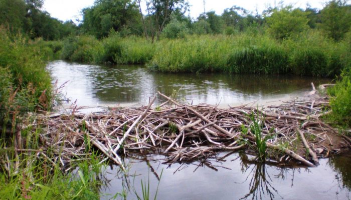
EGU Blogs

351 search results for "black in science"

GeoLog

Imaggeo on Mondays: Velociraptor in the Zagros Mountains

Imaggeo on Mondays: Velociraptor in the Zagros Mountains

How many times have you turned your head up to the sky and spotted familiar shapes in the clouds? Viewing structures from afar can reveal interesting, common and, sometimes, funny patterns. Satellite images are often used to map geological terrains. They offer a bird’s eye view of the planet and the opportunity to see broad scale structures, the scale of which would be impossible to grasp from the ...[Read More]

GeoLog

Imaggeo on Mondays: Sunset over the Labrador Sea

Imaggeo on Mondays: Sunset over the Labrador Sea

Ruby skies and calm waters are the backdrop for this week’s Imaggeo image – one of the ten finalist images in this year’s EGU Photo contest. “I took the picture while on a scientific cruise in West Greenland in 2013,” explains Christof Pearce, a postdoctoral researcher at Stockholm University. “We spent most of the time inside the fjord systems around the Greenland capital, Nuuk, but this specific ...[Read More]

GeoLog

GeoTalk: Meet Andi Rudersdorf, winner of I’m a Geoscientist 2015!

GeoTalk: Meet Andi Rudersdorf, winner of I’m a Geoscientist 2015!

Earlier this year we ran the second I’m a Geoscientist event, an online chat-based game show in which school kids vote for their favourite geoscience communicators. In this week’s GeoTalk, Laura Roberts  talks to Andi Rudersdorf, a neotectonics PhD student and winner of this year’s I’m a Geoscientist… First, for those who didn’t been following I’m a Geoscientist, can you tell us a little about you ...[Read More]

GeoLog

Imaggeo on Mondays: A voyage through scales – The Badlands National Park, South Dakota.

Imaggeo on Mondays: A voyage through scales – The Badlands National Park, South Dakota.

Layer upon layer of sand, clay and silt, cemented together over time to form the sedimentary units of the Badlands National Park in South Dakota, USA. The sediments, delivered by rivers and streams that criss-crossed the landscape, accumulated over a period of millions of years, ranging from the late Cretaceous Period (67 to 75 million years ago) throughout to the Oligocene Epoch (26 to 34 million ...[Read More]

AS
Atmospheric Sciences

An unlikely choice between a gasoline or diesel car…

An unlikely choice between a gasoline or diesel car…

I have recently been confronted with the choice of buying a “new” car and this has proved to be a very tedious task with all the diversity of car that exists on the market today. However, one of my primary concerns was, of course, to find the least polluting car based on my usage (roughly 15000km/year). Cars (or I should say motor vehicles) pollution is one of the major sources of air pollution (p ...[Read More]

GeoLog

Imaggeo on Mondays: Colourful hydrovolcanism

Imaggeo on Mondays:  Colourful hydrovolcanism

Like in a beautiful painting, layers of colour adorn the flanks of this volcano. In this week’s Imaggeo on Monday’s post, Stephanie Flude describes how these colourful layers came to be and gives an insight into why she became a geologist. What inspired you? Share your reasons for becoming a geoscientist with us in the comment section or via twitter using the hashtag #WhyGeo! “Why do you want to s ...[Read More]

GeoLog

Imaggeo on Mondays: Pyroclastic flow, Montserrat

Imaggeo on Mondays:  Pyroclastic flow, Montserrat

Below the warm and tranquil waters of the Caribbean, some 480 km away from Puerto Rico, the North America Plate is being subducted under the Caribbean Plate. This has led to the formation of the Lesser Antilles volcanic arc; the result of the formation of reservoirs of magma as fluids from the down going North America Plate are mixed with the rocks of the overlying Caribbean Plate. The continued m ...[Read More]

GeoLog

Imaggeo on Mondays: High altitude glacier monitoring

Imaggeo on Mondays: High altitude glacier monitoring

What a place to work: Spectacular views from the top of the rugged and icy peaks of Tien Shan mountain range. The desire to better understanding global climate change took Leo Sold to this remote area of Central Asia. The frozen slopes of ice and snow in today’s Imaggeo on Mondays photograph hold some of the keys to understanding how the glaciers in this remote region are being affected by a warmi ...[Read More]

GeoLog

The best of Imaggeo in 2014: in pictures.

The best of Imaggeo in 2014: in pictures.

From the rifting of the African continent, to mighty waterfalls in Slovenia, through to a bird’s eye view of the Glarus Thurst in the Alps, images from Imaggeo, the EGU’s open access geosciences image repository, they have given us some stunning views of the geoscience of Planet Earth and beyond. In this post we have curated some of our favourites, including header images from across our social me ...[Read More]

GeoLog

When Astronomy Gets Closer to Home: Why space weather outreach is important and how to give it impact

When Astronomy Gets Closer to Home: Why space weather outreach is important and how to give it impact

When the public think about natural hazards, space weather is not the first thing to come to mind. Yet, though uncommon, extreme space weather events can have an economic impact similar to that of large floods or earthquakes. Although there have been efforts across various sectors of society to communicate this topic, many people are still quite confused about it, having only a limited understandi ...[Read More]