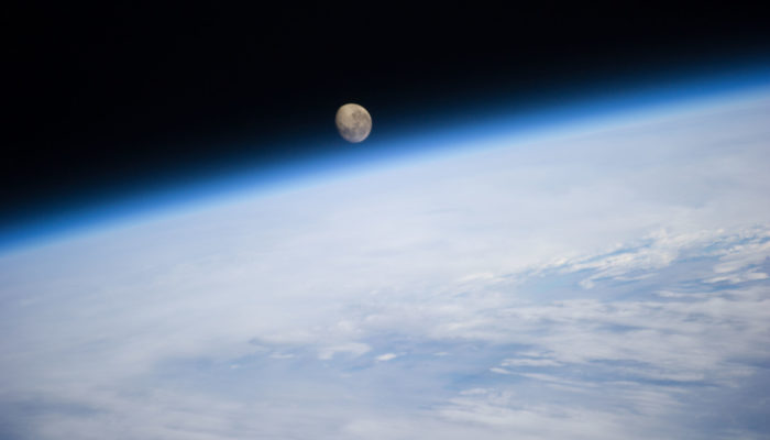
The Greenland ice sheet flows from the interior out to the margins, forming fast flowing, channelized rivers of ice that end in fjords along the coast. Glaciologists call these “outlet glaciers” and a large portion of the mass loss from the Greenland ice sheet is occurring because of changes to these glaciers. The end of the glacier that sits in the fjord is exposed to warm ocean water that can me ...[Read More]
If you didn't find what you was looking for try searching again.
Tectonics and Structural Geology
Folding and Fracturing of Rocks – 50 years of research since the seminal textbook of JG. Ramsay
John G. Ramsay1 wrote his seminal textbook on the folding and fracturing of rocks in 1957, almost 20 years before I was born (and I don’t count myself as young!). So why did I co-convene a session at EGU in 2017 to celebrate the book? Because the book, in many ways, expresses the legacy that John has given to structural geology. He followed it with a series of books of the same ilk – Ramsay ...[Read More]
GeoLog
Imaggeo on Mondays: An epic ‘house’ move across the ice
In 2008 the NEEM Deep Ice Core Project was initiated by 14 partner countries in Northwestern Greenland (camp position 77.45°N 51.06°W) with the aim to drill from the very top of the Greenland ice cap to its base; obtaining ice from as far back as the last interglacial period- the Eemian – some 130,000 years old. At the start of the 2008 field season, the NEEM camp consisted of a single hea ...[Read More]
GeoLog
Extraordinary iridescent clouds inspire Munch’s ‘The Scream’
Edvard Munch’s series of paintings and sketches ‘The Scream’ are some of the most famous works by a Norwegian artist, instantly recognisable and reproduced the world over. But what was the inspiration behind this striking piece of art? The lurid colours and tremulous lines have long been thought to represent Munch’s unstable state of mind; a moment of terror caught in shocking technicolour. At the ...[Read More]
Cryospheric Sciences
Image of the Week — The ice blue eye of the Arctic
“Positive feedback” is a term that regularly pops up when talking about climate change. It does not mean good news, but rather that climate change causes a phenomenon which it turns exacerbates climate change. The image of this week shows a beautiful melt pond in the Arctic sea ice, which is an example of such positive feedback. What is a melt pond? The Arctic sea ice is typically non-smooth, and ...[Read More]
GeoLog
Imaggeo on Mondays: Tones of sand
With rocks dating as far back as the Precambrian, mountain building events, violent volcanic eruptions and being covered, on and off, by shallow seas, Death Valley’s geological history is long and complex. Back in the Cenozoic (65 to 30 million years ago), following a turbulent period which saw the eruption of volcanoes (which in time would form the Sierra Nevada of California) and regional uplift ...[Read More]
Cryospheric Sciences
Ice Cores “For Dummies”
Ice cores are important tools for investigating past climate as they are effectively a continuous record of snowfall, which preserves historical information about climate conditions and atmospheric gas composition. In this new “For Dummies” post, we discuss the history and importance of ice-core science, and look at the way we can use ice core chemistry to reconstruct past climate. Ice sheets, arc ...[Read More]
GeoLog
Imaggeo on Mondays: A look inside a thunderstorm
This week’s contribution to Imaggeo on Mondays is a photograph of a mesocyclone – and its rotating wall cloud – photographed by Mareike Schuster, an atmospheric scientist from Freie Universität Berlin, Germany. The picture was taken in June 2012 near Cheyenne, Wyoming in the United States during a field campaign, ROTATE, led by the Center for Severe Weather Research, based in Boulder, Colora ...[Read More]
GeoLog
Imaggeo on Mondays: Why does a Norwegian glacier look blue?
This picture shows the outlet glacier Engabreen running down from the plateau of Svartisen in Norway. Svartisen ice cap comprises two glacier systems of which the Vestre (western) Svartisen is Norway’s second largest glacier. Located right at the polar circle, Svartisen covers a total of 369 km² of the Nordland region. These coastal mountains accumulate a snowpack of 5-7 m depth through the winter ...[Read More]
GeoLog
Imaggeo on Mondays: The odd ‘living’ rocks
Microbialites – structures which result from the interaction between microbes and sediments – have existed in the rock record since 3700 Ma ago until the present day. The presence of microbes in environments where mineral precipitation is prevalent, usually derives in the development of such chemical sedimentary structures. This can take place in marine, non-marine, and subterranean environm ...[Read More]