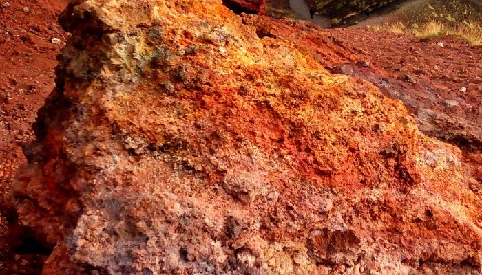
In this week’s Imaggeo on Monday’s image an almost Martian looking landscape, with ombre coloured soils, gives way to gently rolling hills, covered in luscious woods and vegetation. Were it not for the trees in the distance, you would be forgiven for thinking this image had been captured by a Mars rover. In truth, it is an entirely more earthly landscape: welcome to the slopes of Mt. Etna! Keep on reading as Alicia Mourgán, a researcher at the University of València, gives an overview of the origin of the richly fertile soils and climate of Europe’s tallest active volcano.
Mount Etna is associated with the subduction of the African Plate under the Eurasian Plate. A number of theories have been proposed to explain Etna’s location and eruptive history: rifting processes, a hot spot, and the intersection of structural breaks in the crust. Scientists are still debating which best fits their data, and are using a variety of methods to build a better image of the Earth’s crust underneath the volcano.
The soil around the volcano is very rich in minerals, owing to its volcanic origin. It is composed of a number of eruptive materials of different ages, including ash, sand and desintegrated lava (from one or more flows). Volcanic rocks make some of the best soils on Earth: not only are they formed of a wide variety of common elements, these readily separate into their elemental forms.
In the Etna region there are substantial differences in climate, not only compared to the rest of Sicily, but also from one area of the volcano to another. This is due to the fact that the Etna region has semi-circular shape, spread from north to south-west. This characteristic allows for different environments to be formed each with its own microclimate, benefiting from different exposure and changing proximity to the sea. Altitude in the Etna region varies between 450 m and 1100m above sea level. This factor is the main reason for the temperature changes between the day and night and also across seasons.
Compared to the rest of Sicily, Etna is pretty wet too. The highest levels of precipitation are recorded on the east slopes of the volcano. Rain can be practically absent over the summer, but precipitation can also be very high during the autumn/winter period.
By Alicia Morugán, University de València, València, Spain
Imaggeo is the EGU’s online open access geosciences image repository. All geoscientists (and others) can submit their photographs and videos to this repository and, since it is open access, these images can be used for free by scientists for their presentations or publications, by educators and the general public, and some images can even be used freely for commercial purposes. Photographers also retain full rights of use, as Imaggeo images are licensed and distributed by the EGU under a Creative Commons licence. Submit your photos at http://imaggeo.egu.eu/upload/.


