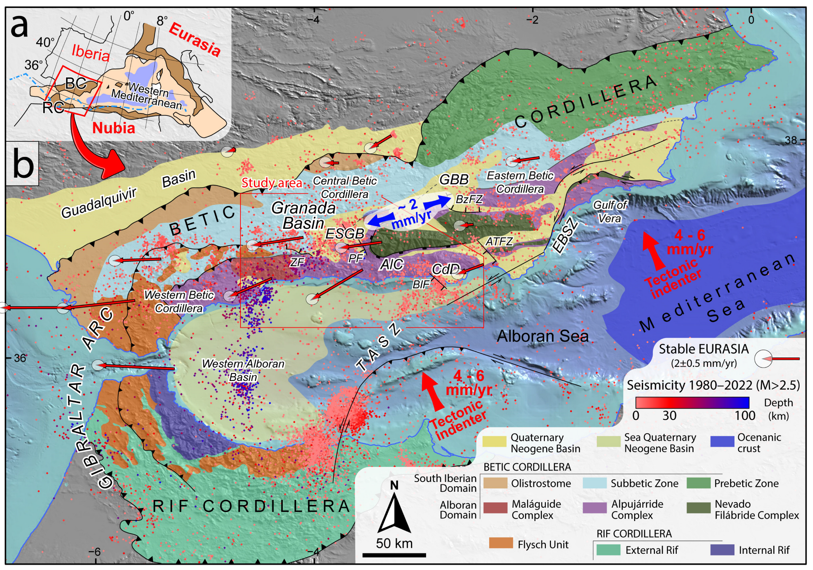
Alright, buckle up folks for this blog post, because we’re about to explore the wild ride of plate tectonics between the Iberian Peninsula (Eurasia plate) and North Africa (Nubia plate). These two plates are moving slowly at a moderate pace of 5-7 mm per year, which might not seem like much, but it’s enough to shake things up—literally!
In a recent paper, published by our journal Solid Earth (SE), the authors explored these movements and noticed that some parts of the plates are squishing together (shortening), some are pulling apart (extension), and others are sliding past each other at weird angles (oblique kinematics). Right in the middle of this tectonic movement lies the central Betic Cordillera. This region is stretching east-northeast to west-southwest, thanks to some active faults oriented north-northwest to south-southeast.
Because of all this geological phenomenon, the central Betic Cordillera is one of the most active seismic zones in the Iberian Peninsula. It has been subject to some serious action over the years, including Spain’s most destructive earthquake—the 1884 Andalusian earthquake (with a magnitude of 6.5). Other notable quakes include the 1531 Baza earthquake (magnitude around 6.0), the 1964 Galera earthquake (magnitude 4.8), and the 2021 Granada seismic sequence.
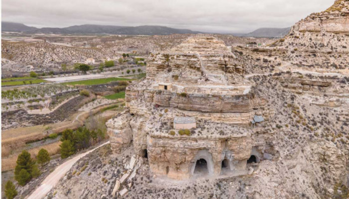
This region isn’t just tectonically active; it’s also historically renowned for its ongoing human activity, from prehistoric times to modern urban centers like Granada, Guadix, and Baza.
Cracking the code of seismic hazards
Given the constant tectonic movements, it’s crucial to assess the seismic hazard in the central Betic Cordillera. The more data the scientists have, the better their predictions can be. But relying only on historical and instrumental records isn’t enough, especially for slow-moving faults with long breaks between big quakes. That’s where palaeoseismology comes in—to help us dig into ancient earthquakes and perhaps find some answers.
Unfortunately, palaeoseismic data in this area is rare. The first data came from a study on the Padul Fault, which found evidence of earthquakes from around 35,000 to 30,000 years ago. Another study on the Ventas de Zafarraya Fault identified two big quakes in the last 10,000 years, with a major one happening before the 1884 quake. The Baza Fault study found eight to nine big earthquakes in the last 45,000 years, with intervals of about 5,000 years between them.
In this project, the authors seem to have provided the first palaeoseismic data from the Galera Fault. They dug up evidence from two trench sites and analysed the dirt to map out the fault’s earthquake history. Using Bayesian analysis (think high-tech detective work), they modelled the surface-rupturing history and calculated the intervals between earthquakes. The aim of their publication is to examine how these earthquakes might have grouped together over time and assessing the fault’s seismic potential, and finding out how these ancient earthquakes might have impacted Bronze Age humans living nearby.
Findings:
Over the past 14,000 years, the Galera Fault (GF) has been a key player in shaping the landscape through a series of significant earthquakes. This fault, stretching 30 km without any clear divisions, has experienced at least seven or eight major surface-rupturing events. By analysing data from two paleoseismological sites: the The Rambla de los Pilares and The Barranco del Rubio (PIL and RUB), researchers pieced together the fault’s complex seismic history.
In their analysis, they focused on events at the RUB that definitively caused surface ruptures, ensuring a more accurate timeline. Interestingly, the data from PIL and RUB didn’t always align perfectly. Depending on whether an event at PIL (called PIL_e4) is considered distinct or the same as one at RUB, the GF’s history could involve either eight or seven major earthquakes over the last 24,000 years.
These seismic events haven’t been evenly distributed over time. The GF seems to show a pattern of clustering, with one particularly active period around 1536–1126 BCE, during which five earthquakes occurred in just 400 years. This burst of activity contrasts sharply with the following 3,200 years, where only two earthquakes were recorded. This clustering might be linked to stress interactions between the GF and nearby faults.
Looking further into the seismic potential of the GF, researchers calculated the maximum expected earthquake magnitude (Mmax) to be around 6.7. They also estimated the average time between such large events to be approximately 1,857 years. These findings suggest that the GF is capable of generating powerful earthquakes that could have a significant impact on the region.
The end of the Argaric culture in southeastern Spain took place in ca. 1300 BCE because of a crisis probably related to its forms of social exploitation […] the two Bronze Age archaeological sites near the GF […] were abandoned in approximately 1500 BCE,[…] We hypothesize that the GF seismic crisis could have played a key role by adding extra stress to the societal crisis, thereby leading to an early abandonment of the settlements.
One of the most intriguing aspects of this study is the possible connection between these ancient earthquakes and the abrupt abandonment of two Bronze Age settlements—Castellón Alto and Cerro de la Virgen—located near the GF. These sites were deserted around 1500 BCE, roughly coinciding with the period of intense seismic activity. This raises the possibility that the stress from these earthquakes contributed to the early collapse of these communities and offers an insight into how natural forces may have shaped human history.
Understanding human-nature relationships through Paleoseismology:
The natural world has influenced human development throughout thousands of years of documented history. Seismology, the study of earthquakes and the forces behind them, gives us a unique lens to explore these interactions and hepls us comprehend how ancient societies might have responded to the powerful forces of our planet and its climate.
Historically, human settlements have often been situated in areas where natural resources are abundant, however, these regions are also sometimes prone to natural disasters such as earthquakes. Although the central Betic Cordillera’s fertile lands and strategic location attracted settlers, it has always been at the mercy of the tectonic forces between the Eurasian and Nubian plates. The earthquakes that have shaped the landscape for millennia serve as reminders of nature’s capacity to both nurture and challenge human life.
Paleoseismology is thus a tool to get a glimpse of how our ancestors might have experienced and responded to such dramatic environmental changes. For instance, this study of the Galera Fault reveals periods of intense seismic activity that coincided with significant cultural shifts, such as the abrupt abandonment of two Bronze Age settlements. This suggests that ancient communities were not only aware of these natural hazards but were also forced to adapt to them. This knowledge can inform our current relationship with the natural world and reminds us of the ongoing need to study our planet’s unpredictability and driving forces, for the sake of our species’ survival. As modern societies continue to develop in seismically active regions, the lessons of the past remain invaluable. They remind us not only of our vulnerability to Earth’s forces, but of our need to be resilient and simultaneously connected to this planet that sustains our lives.


