Effective responses to natural disasters require the rapid acquisition of information about where has been affected, how many people are in the affected areas and what the magnitude of the damage is. This information is critical in both disaster and emergency rescue management. Indeed, the first three days after the onset of a disaster has been dubbed the “72-hour golden rescue period”, after which the survival rate of victims sharply declines. With this in mind, the need for rapid data collection could not be more evident.
Aerial photography is a useful tool in determining which areas have been affected by an earthquake, but resolution may not always be adequate to determine the damage to buildings and infrastructure within them. For this, satellite technology provides a helping hand. For example, the spectral characteristics of a building can be used to determine whether or not it has been structurally damaged. There is, however, a time delay associated with gathering and analysing satellite data and it is ineffective for more minor quakes. More importantly though, these tools provide no indication of the number of people affected within these areas beyond the assumed population density (affected rural land is likely to have fewer people immediately at risk than in an affected urban area).

Building collapse as a result of the 1995 Hanshin-Awaji earthquake [Source: Wikimedia Commons].
This is where Dr Jing Hai Xu and his team come in, as they have developed a method of using text messages to report and disseminate disaster information and Geographic Information Systems (GIS) to analyse and extract details relevant to search and rescue teams.
The network is separated into country level, provincial level, and city level, with the smallest components being streets within a town or city. One reporter is enough to include the impact on a particular location in the disaster information network. One downside of the model, though, is that the reporters need to be formal local government employees. Whilst this measure is proposed to increase the reliability of reports, it vastly reduces the number of people that can feed into the network. Perhaps an alternative way of addressing the problem of reliability would be to only include information in the network after multiple reports of a similar incident are received from the same area. Here we are faced with new problems: what constitutes one area? Will reports of the same event from different observers be sufficiently similar to be picked up in the network? This also requires the contact details of the disaster network to be disseminated to a greater proportion of the population… perhaps Xu et al.’s approach is an effective one after all!
Now that that’s decided – how does it work? Principally, there are two kinds of nodes that help the network function: 1) edge nodes, these are the people responsible for reporting disaster information, and 2) central nodes, which correspond to the central earthquake office within each city and are responsible for collecting and disseminating information. After an earthquake, the city earthquake office (central node) contacts the reporters (edge nodes), asking for information about the impact of the disaster where they are. This information is fed back to the office and these central nodes pass the information on to the provincial offices and then on to the country’s government office so that appropriate action can be taken.
Having a simple code for different impacts helps collate useful information. In this model, the first number indicates the type of damage (e.g. 4 for damage to buildings) and the second indicates the severity (with 1 being low severity and 5 being high). So the code for a few damaged buildings would be 42, or 44 for a large quantity of damaged buildings, with some partially collapsed, etc. Here are the other codes:

Earthquake disaster information codes (click to enlarge), [modified from Xu et al., 2013].

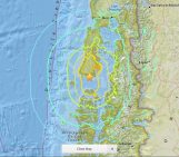
Disaster information distribution (level of shaking) from the 2012 Yangzhou earthquake, [modified from Xu et al., 2013].
So there you have it – the key to disaster management success: send an SMS.
By Sara Mynott
Reference:
Xu, J. H., Nie, G. Z., and Xu, X.: A digital social network for rapid collection of earthquake disaster information, Nat. Hazards Earth Syst. Sci., 13, 385-394, doi:10.5194/nhess-13-385-2013, 2013


Ekbal Hussain
This is a really great idea and one which has a lot of potential. It won’t be that big of a jump to include other forms of social media (twitter, facebook etc) into this framework as well.
I particularly like the simple logical code for different impacts.
However, the critical flaw in this approach is that it requires a network connection which very often might not be the case after a particularly strong disaster. Therefore, in my opinion this should always be a one of multiple tools used to assess the local severity of a disaster.
Sara Mynott
Thanks Ekbal – I am indeed hoping to follow this up with a post on the use of online media (twitter, facebook etc.) as a means of collating disaster information!
I agree that the underlying flaw here is the reliance on network availability, and it is also a problem when using information from online networks. While we cannot rely on one tool to gather and disseminate all the information needed to respond to a disaster – or even guarantee it’s efficacy – networks such as this have a lot of potential for use in moderate disasters.