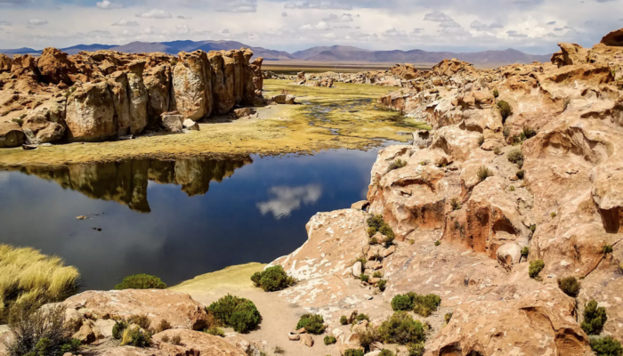
This week’s featured photo showcases one of the most geologically diverse landscapes of South America: the Altiplano, the high plateau of the Andes. This plateau covers roughly 200,000 square kilometres in central South America, stretching from southern Peru to northern Argentina. The high-elevation plain sits between the eastern and western chains of the Central Andes and is home to a myriad of natural features, from vast bright-white salt flats and volcanic rocks to strikingly colorful lakes inhabited by flocks of flamingos. The place is also a hub for geoscientific research – such as studying the region’s unusually thick crust and extracting palaeoclimatic data from its alpine glaciers. It comes as no surprise then that many geoscientists even make the journey to this geologically interesting place during their down time.
Katleen Wils, a researcher at Ghent University in Belgium, traveled on holiday to the Bolivian section of the Altiplano, spending three days in the Salar de Uyuni, the largest salt flat in the world. “We were amazed multiple times by the beautiful scenery!” said Wils. “We were definitely not alone on the saltpan itself, but once going into the mountains, it was mostly just our group. This allowed us to even more enjoy the quietness, the beautiful views and just sit and enjoy the moment.”
On her trip, Wils had the chance to visit the Laguna Negra, which is highlighted in the photo above. Most of the lakes in the region are easily accessible from a car, but to get a glimpse of the scenic yet remote Laguna Negra, Wils explained that she and her group had to take a longer trek through the upland environment.
“We had to walk over quite a distance along a riverbed, crossing all kinds of bird species, surrounded by the volcanic rocks in the area. As there was still some water present in the bed, it involved quite a lot of jumping over smaller flows, making sure our feet didn’t sink into the mud, and finding the best way to cross without getting our feet wet.”
Their efforts were rewarded with a beautiful viewpoint of the lake, enclosed by jutting red rocks. “The fact that we had to walk to get there, made it even more idyllic, as it was a really remote location where it was just us. We sat there for at least an hour, I think, taking up the landscape,” said Wils. “For me, this is the best thing to unwind, I can just forget all of my thoughts and feel completely relaxed in the beauty of nature. That’s my idea of an ideal vacation!”
By Olivia Trani, EGU Communications Officer
Imaggeo is the EGU’s online open access geosciences image repository. All geoscientists (and others) can submit their photographs and videos to this repository and, since it is open access, these images can be used for free by scientists for their presentations or publications, by educators and the general public, and some images can even be used freely for commercial purposes. Photographers also retain full rights of use, as Imaggeo images are licensed and distributed by the EGU under a Creative Commons licence. Submit your photos at http://imaggeo.egu.eu/upload/.