Unravelling the secrets of past civilisations is tricky at the best of times. More so if many of the records which hold clues about how communities lived, built their homes and temples, as well as how they fed themselves, were destroyed by subsequent invaders. In these instances, as Felix Rodriguez Cardozo explains in today’s post, geophysical techniques (such as Lidar, which very recently hit the headlines for contributing to discover new Cambodian temples close to Angkor Wat) can be a great asset to traditional archaeological methods.
The Yucatan Peninsula, in the southeast of Mexico, is a gorgeous place not only because of the natural landscape but also due to the marvellous structures built by indigenous cultures prior to the European colonization process during the 17th Century. While it is widely known that there are several and complex indigenous structures built by different cultures along Mexico, the Yucatan’s structures blend in perfectly with the jungle, complementing rather than contrasting with the natural landscape.
Although Mexico is a country surrounded by a vast amount of natural hazards (eg. earthquakes, volcanism, hurricanes, etc.) many of the ancient structures have shown an extraordinary skill for resisting all of them. Unfortunately, during the colonization period much of the information related to the ancient cultures of México (and America in general) disappeared, including the information on the building techniques used employed to erect these incredible structures.
All was not lost! Thanks to the archaeology and more recently, other disciplines like geophysics, we can now figure out with certain confidence the technology and building methods used by our american ancestors.
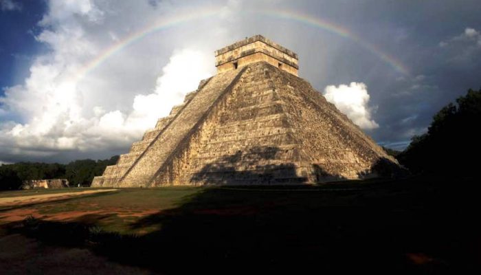
I took this photo while conducting a geoelectric and geomagnetic survey to try and discover the foundations of the Kukulklán pyramid and learn more about its internal structure. While the photo does not show any device used during the survey, it does portray perfectly the harmony between the indigenous building and the surrounding nature, something uncommon in modern society. ,
By Félix Rodríguez Cardozo
Imaggeo is the EGU’s online open access geosciences image repository. All geoscientists (and others) can submit their photographs and videos to this repository and, since it is open access, these images can be used for free by scientists for their presentations or publications, by educators and the general public, and some images can even be used freely for commercial purposes. Photographers also retain full rights of use, as Imaggeo images are licensed and distributed by the EGU under a Creative Commons licence. Submit your photos at http://imaggeo.egu.eu/upload/.