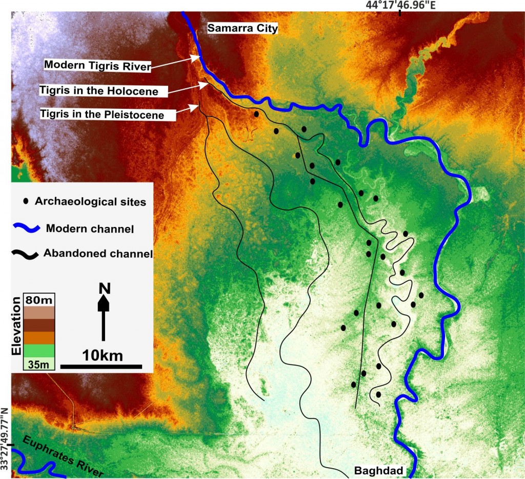
SRTM map shows ancient course of Tigris River in Iraq (update from the version available on imaggeo.egu.eu).
Mesopotamia, an area rich in history and considered as the cradle of civilisation, with the first populations establishing themselves in the region some 6000 years ago,lies between two great rivers: the Euphrates and the Tigris. The ancient territory spans areas of modern-day Iraq, Kuwait, the northeastern section of Syria and small sections of southeastern Turkey and southwestern Iran.
The history of Mesopotamia is intrinsically linked to the great rivers which define it. From changes of the river themselves (autogenic), through to non-living environmental factors (known as allogenic) and human activities, the rivers respond to a wide range of processes by changing their courses and forming new waterways.
However, keeping track of the river’s changing paths during their long histories can be tricky. Based on a common assumption made by archaeological studies of the Mesopotamian floodplain, where periods of activity of a river channel are considered to be closely linked to the ages of archaeological settlements, Jaafar H. Jotheri, (a PhD researcher at the University of Durham, UK), was able to study the history of the two rivers.
Most of the identified ancient settlements in the region are thought to have been established near active channels. “Therefore, the existence of settlements in certain areas is a good indication of the probability of the existence of a river close to the site and vice versa,” explains Jaafar. “Not only that, the ages of a settlement can give a suggested age during which a particular river channel was active,” he adds.
Cuneiform script, a style of writing which involved pressing a stylus into soft clay tablets and making indentations representing word-signs, was widely used in ancient Mesopotamia. A number of middle to late Holocene cuneiform tablets make direct reference to rivers. They often record instances in which settlers interacted with the rivers: the digging of new irrigation channels, the annual cleaning of a river or using the river to transport goods from one city to another.
“These texts are useful to determine the locations and period of existence of rivers, particularly when some texts refer to identified sites,” explains Jaafar.
Using this information, Jaafar has been able to identify and map three main courses of the Tigris, during three different time periods. These are, from oldest to the youngest: the Pleistocene course, the Holocene course and the modern course, as are seen in this week’s Imaggeo on Monday’s image.
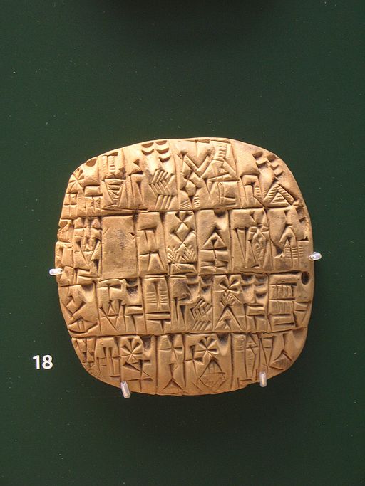
Sumerian Cuneiform on a clay tablet. From Shuruppak or Abu Salabikh, Iraq, circa 2,500 BCE. British Museum, London. Credit: Gavin.collins, distributed via Wikimedia Commons.
No archaeological sites were found associated with the Pleistocene course, compared to the Holocene course, with which many archaeological sites are associated (dated from ~ 4000BC to 1200 AD).
“We have historical texts that suggest that the Holocene Tigris channel was abandoned and relocated to form the new modern course after 1258 AD, in a process known as avulsion” says Jaffar, “there is also an indication that human activity might have been a trigger for the avulsion,” he adds.
The historical text indicate that farmers broke the banks of the Holocene aged channel of the river Tigris, digging irrigation canals to water low elevation farms. The newly excavated channel (or canal) became the main waterway.
Imaggeo is the EGU’s online open access geosciences image repository. All geoscientists (and others) can submit their photographs and videos to this repository and, since it is open access, these images can be used for free by scientists for their presentations or publications, by educators and the general public, and some images can even be used freely for commercial purposes. Photographers also retain full rights of use, as Imaggeo images are licensed and distributed by the EGU under a Creative Commons licence. Submit your photos at http://imaggeo.egu.eu/upload/.