In this week’s Imaggeo on Mondays, Ian Watkinson transports us to the Sulaiman Mountain Range and shows why it’s always worth bringing a camera in your hand luggage…

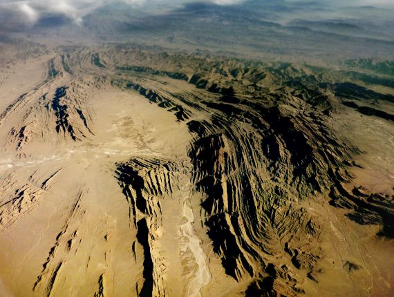
“Plunge” by Ian Watkinson, distributed by the EGU under a Creative Commons licence.
This image is the view from the window of a plane crossing the Pakistan-Afghanistan border close to Zhob. I took it just before the weather closed in on a clear crossing of the Indus valley foreland and the entire Sulaiman Mountain Range. The Sulaiman ranges are a spectacularly lobate fold and thrust belt that is slowly being transported south-eastward over the Indian Plate as it collides with Eurasia.
The Katawaz Basin is sandwiched between an active foreland fold and thrust belt, which accommodates oblique shortening, and the sinistral Chaman Fault, which accommodates lateral motion. The basin is filled with marine sedimentary rocks that formed during the Eocene-Miocene, known as the Khojak flysch. The flysch are a thick package of marine sandstones and shales that overlay ophiolites – areas of oceanic plate that have been thrust onto the edge of a continental one, and mark the suture between India and Eurasia. Gently plunging fault-related folds deform the flysch – and you can see a number of these folds in my photo.
The Katawatz Basin ophiolites and the Sulaiman fold and thrust belt are important because they record the final closure of Neo-Tethyan ocean basins around the western margin of India, and its subsequent and ongoing collision with Eurasia. Fold and thrust belts, such as the Himalayas and the Indo-Myanmar ranges, fringe much of the northern Indian Plate, but the Sulaiman ranges are perhaps the most clearly exposed from the air.

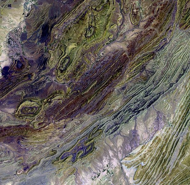
Part of the Sulaiman Mountain Range as seen from space. (Credit: NASA/USGS EROS Data Center)
Finally, here’s how I took the photo: I had to increase the contrast of this image to remove thick haze in the lower atmosphere. At the time I had also been experimenting with applying narrow depth of field effects to digital elevation models to enhance the impression of distance, so I applied the technique to this image as it looks a little like a digital elevation model.
By Ian Watkinson, Royal Holloway University of London
References:
Jadoon, I. A. K., Lawrence, R. D. and Lillie, R. J.: Seismic Data, Geometry, Evolution, and Shortening in the Active Sulaiman Fold-and-Thrust Belt of Pakistan, Southwest of the Himalayas. AAPG Bulletin, 78, 758-774, 1994
Gnos, E., Immenhauser, A. and Peters, T.: Late Cretaceous/early Tertiary convergence between the Indian and Arabian plates recorded in ophiolites and related sediments. Tectonophysics, 271, 1–19, 1997
The EGU’s open access geoscience image repository has a new and improved home at http://imaggeo.egu.eu! We’ve redesigned the website to give the database a more modern, image-based layout and have implemented a fully responsive page design. This means the new website adapts to the visitor’s screen size and looks good whether you’re using a smartphone, tablet or laptop.
Photos uploaded to Imaggeo are licensed under Creative Commons, meaning they can be used by scientists, the public, and even the press, provided the original author is credited. Further, you can now choose how you would like to licence your work. Users can also connect to Imaggeo through their social media accounts too! Find out more about the relaunch on the EGU website.


