This edition of ‘Features from the field’ is brought to you by Faris Beg, a masters student on the EU Erasmus Mundus Joint Master’s program in planetary geosciences—GeoPlaNet. This blog is a result of a geological field excursion carried out collectively in groups by students, organized by the GeoPlaNet consortium in Alcañiz, Spain. He will be talking about his observations and learnings on the exhumed river channels, during this field excursion.
Did you know one of the most striking pieces of evidence for the existence of water on ancient Mars comes from certain geological features cropped out from underneath the Earth surface as a result of erosion? We call them exhumed or inverted river bodies.
In planetary analogous studies, we make comparisons between high-resolution image data (CTX, HiRISE—Mars Reconnaissance Orbiter) from the Martian surface and Earth’s geomorphology. In certain valley regions near dried up alluvial fans on Mars, we come across ridge-like relief features (Jet Propulsion Laboratory, 2000). These are analogous to geomorphological evidence of exhumed channels in several terrestrial basins on Earth. In order to understand what might have happened on Mars, we try to draw inferences from terrestrial analogues.
On Earth, several ridge features recorded as formations of differential erosion of fine grained mudstone and coarse grained sandstone rocks have been referred to as exhumed or inverted river channels. We will try to understand exhumed channels in the light of observations made in one such analogous site in the South-East Ebro basin in Spain. The central idea is to identify features that make for reliable evidence of water flow in the past as this would eventually help us derive similar proofs of fluvial activity on analogous Martian topography.
Previous studies conducted in the Ebro basin have established the age of depositional period as Oligocene to Miocene, during which the litho-facies were formed either by channelized or un-channelized flow deposition, resulting in ribbon-like, multistorey, sandstone ridge structures as exhumed river channels (Cuevas et al., 2010).
But how does this general structure of exhumed channels come about?
When the river flows carrying sediment load, the energy of flow is higher within channels compared to outside of channels. This makes the coarser sandstone sediments deposit within the channel, and therefore, channelized deposits form slightly sinuous ribbon-like sandstone bodies (Figure 1).
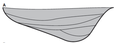
Figure 1: Cross-sectional morphology of the channel fill. Vertically stacked sandstone beds with both banks (fine grained) erosional. Credit: (Cuevas et al., 2010)
On the other hand, the load carried by water outside the channel is finer mudstone. It forms fine grained mudstone tabular bodies, essentially, as overbank/floodplain deposits on side flanks of the main channel sandstone body. Now, when the basin dries up, aeolian forces (wind) start scraping away loosely consolidated mudstone and clay rocks more easily compared to more tightly packed sandstone rocks. Over geological time, exhumation occurs, which is exposure of buried rocks as they approach the surface (Figure 2). This is the reason why originally deposited sandstone bodies crop out as geomorphological ridges resembling ribbon structures with eroded mudstone deposits on both ends of a central sandstone body.
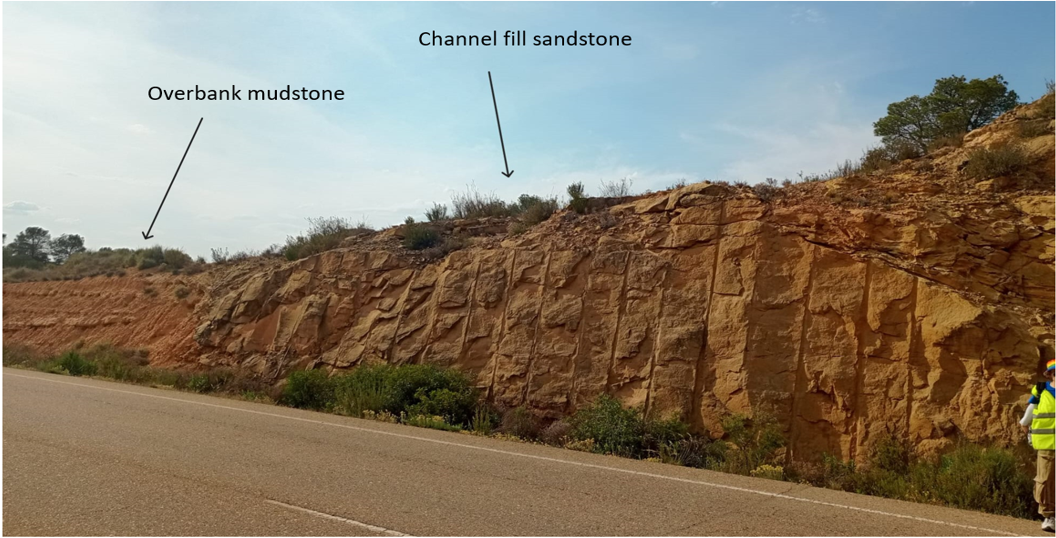
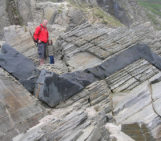
Figure 2: A ribbon like sandstone ridge with less consolidated finer grained mudstone on ends in Alcaniz, Spain
Evidence of fluvial environment: A case study
Now, let’s have a look at one such ribbon-like multistory sandstone body exposed in a road-cut outcrop near the town of Alcaniz (Spain). We will try to understand the lithology, interpret the environments in which these strata were formed, and analyse the paleo-climatic features in detail.
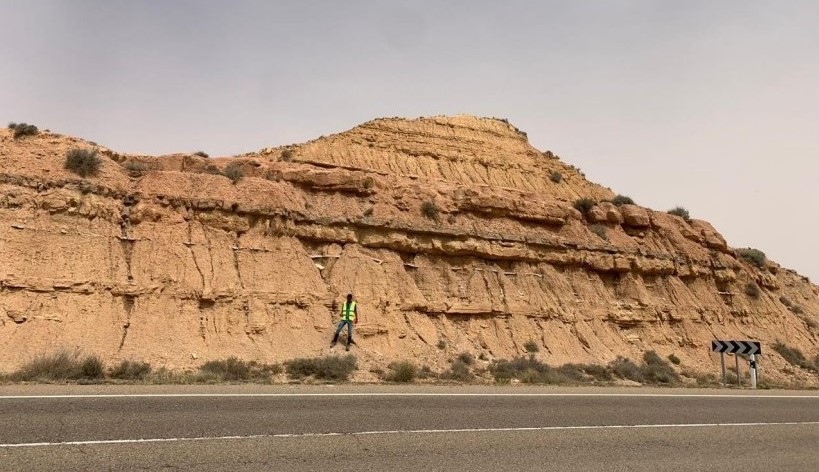
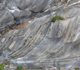
Figure 3: NW face of the road-cut outcrop
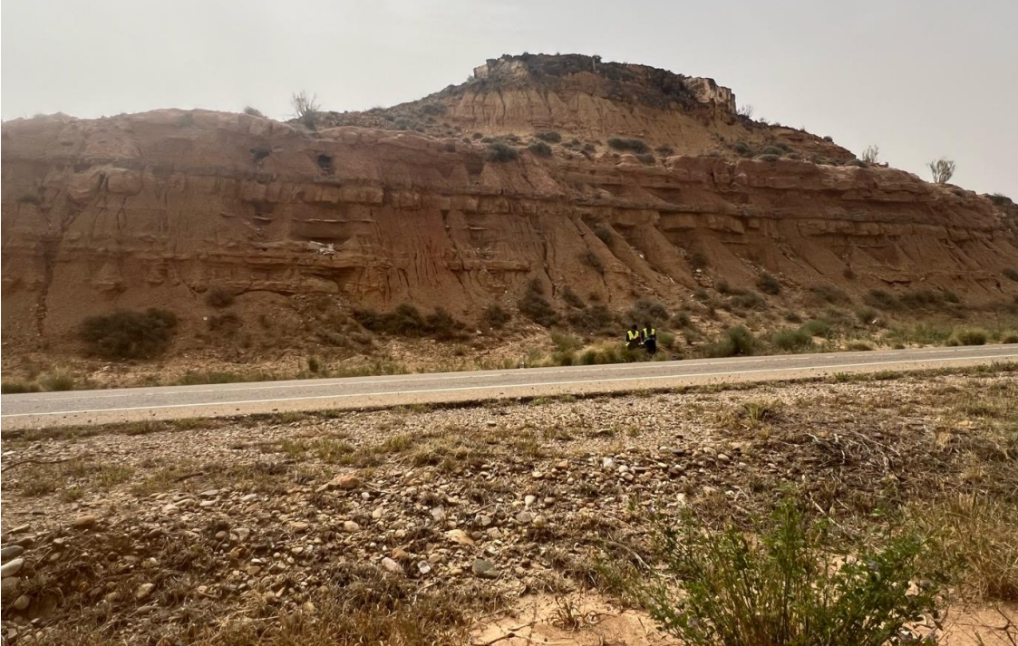
Figure 4: SE face of the road-cut outcrop
The outcrop showcases a typical ribbon sandstone characteristic of the Ebro basin (Figure 3 and 4), indicating two main categories of fluvial deposition: channelized deposition and unchannelised deposition, or floodplain deposits (see Figure 6).
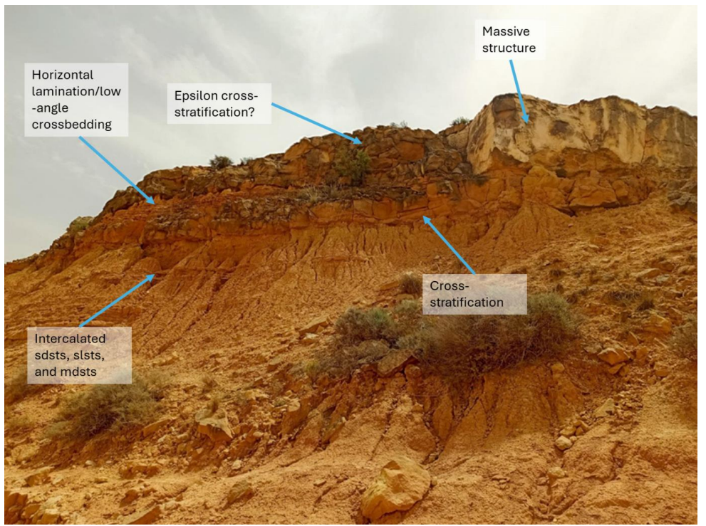
Figure 5: Close-up of SE face of the outcrop. (Note: sdsts = sandstones, slsts = siltstones, mdsts = mudstones)
Lithology analysis of the SE face suggested that below the main channel sandstone body (massive structure), the sandstones here are also intercalated with thin beds of siltstones and mudstones (Figure 5). Whilst the high energy deposition of coarser grained sandstone (Figure 6) was inside a channel, the finer sandstone intercalated with siltstones and mudstones belong to the floodplain deposits possibly of surrounding channels in the local region.
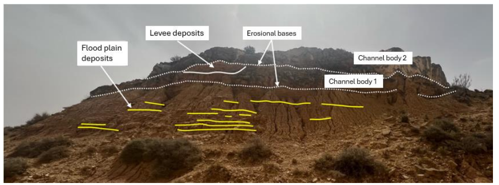
Figure 6: Lithology of upper part of SE face of the outcrop
The channel bodies are relatively large with distinct erosional bases (Figure 6). They can be interpreted to have been aggraded and slightly accreted due to the possible presence of epsilon cross-stratification as depicted in figure 5 (side bar deposits). This is a characteristic feature of meandering rivers when they shift laterally accreting depositional mass. In such a scenario, a lateral accretion SSW against the paleo-current of NE-SW can be established, although the lateral accretion is not major, as the sinuosity of this channel is low.
Gypsum Layer
Somewhere below the intercalations, we found a remarkable feature in the form of a greyish thin layer of gypsum with vertical cleavages, in a reddish unconsolidated layer of sand. A viable explanation for this could be deposition in a lacustrine environment or a lake, characterised by sluggish, poorly drained flow, close to the distal end of the river, possibly a deltaic plain, where the river meets a standing body of water. During periods of low energy, precipitation of dissolved evaporites like gypsum takes place. In simple words, during arid, hot environmental conditions when the water was almost standing still, the dissolved evaporites settled down as thin layers of Gypsum. Upon this, in later periods, the channel body with high energy flows over, forming such lithology. Although we did not find organic material in this particular region, the exhumed channels in other parts of the basin are rich in micro-fossils and thus make for a potential landing site on similar Martian geomorphology.
Conclusion
All things considered, the outcrop offers a thorough record of historical climate and riverine processes in the Ebro Basin, demonstrating the dynamic character of this depositional system. When this is compared with analogous cropping out rifts around major valleys on Mars, an inevitable link to the ancient fluvial system on the Martian planet could be established and that makes evidence for well-established fluvial environments on Mars more concrete.
References
Cuevas, Jose & Cabrera, Lluís & Marcuello, Alex & Arbués, P. & Marzo, Mariano & BELLMUNT, FABIA. (2010). Exhumed channel sandstone networks within fluvial fan deposits from the Oligo‐Miocene Caspe Formation, South‐east Ebro Basin (North‐east Spain). Sedimentology. 57. 162 – 189. 10.1111/j.1365-3091.2009.01096.x.
Jet Propulsion Laboratory. (2000, September 16). Exhumed crater in Kasei Valles. NASA. Retrieved July 25, 2024, from https://www.jpl.nasa.gov/images/pia01475-exhumed-crater-in-kasei-valles